
Rare snowstorm hits Chicago, breaking 109-year-old snow record

Image credit: i_fish
An unusually strong late-season snowstorm hit parts of United States on April 27 and 28, 2019, dropping heavy snow and causing hundreds of flights to be canceled.
Chicago O'Hare International airport received 6.3 cm (2.5 inches) of snow on April 27, breaking the record for the date set in 1950 at 0.5 cm (0.2 inches). The snow forced cancelations of more than 700 flights at the airport.
The last time this much snow fell this late was back in 1910, AccuWeather Senior Meteorologist Alan Reppert said.
The latest date on record for any measurable snow is May 11, 1996, Reppert said. Some snowflakes, however, have been seen as late as May 22 in 1917.
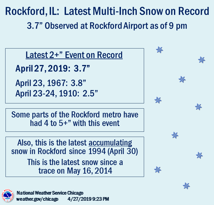
As of 21:00 local time, April 27, Rockford, IL received 9.3 cm (3.7 inches) snow. This is its first snow since 2014, first accumulating snow since 1994 and the first time the city received 5+ cm (2+ inches) od snow since records began in 1906.
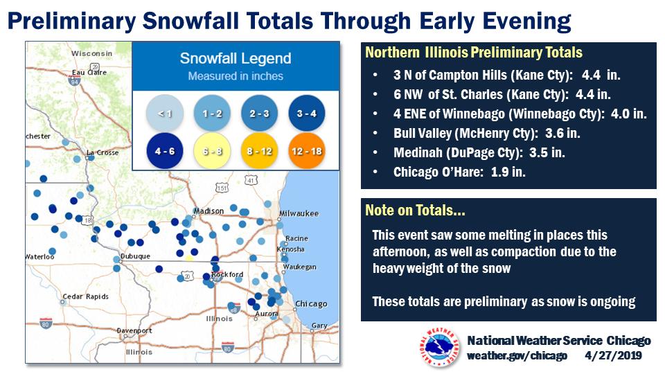
Between 7.6 – 15 cm (3 – 6 inches) of snow fell across a narrow swath of northeast Iowa, northern Illinois and southern Wisconsin.
The #snow is coming down pretty heavy. Thank goodness it’s not sticking #Chicago pic.twitter.com/VHEL3bdcqq
— Neal Shact (@nealshact) April 27, 2019
Downtown Chicago right now. Moderate and heavy snowfall. @weatherchannel @WeatherNation @breakingweather @NWSChicago #ILwx #Chicagoweather pic.twitter.com/HDZF2hEBpI
— Delé Balogun (@delesbalogun) April 27, 2019
Enjoying the spring weather #chicago #Snow pic.twitter.com/eVQtn0El4i
— AILEEN (@aileenocana) April 28, 2019
This is NOT photoshopped picture. This is –#Chicago on 4/27/2019 (YES APRIL).
Just sayin….. pic.twitter.com/2A4ovAFoAs— chadi nabhan MD, MBA (@chadinabhan) April 28, 2019
Showers are expected across parts of the Mid-Atlantic region and southern New England early on Sunday in association with a progressive surface low, with some snow showers possible across the higher elevations of upstate New York, NWS forecaster Hamrick noted.
Improving conditions should return by Sunday night as a high-quality airmass settles in from the Ohio Valley to New England to begin the work week.
However, warm air advection ahead of the next storm system will lead to increasing clouds and more showers by Monday night, April 29 and into Tuesday, April 30.
The next low pressure system developing in response to a closed upper level low over Montana is resulting in snow showers across the northern Rockies to North Dakota.
Additional showers and storms are forecast to develop across the central plains as the frontal boundary intersects an increasingly more humid airmass from the Gulf of Mexico.
The heaviest rain is likely from Kansas to Indiana, with some locations getting 25 to 75 mm (1 to 3 inches) of rain by Tuesday morning.
By Monday, the threat of severe weather increases across the southern plains with the best moisture and upper level forcing residing over this region.
Temperatures will continue to remain below average across the northern tier of the nation through the beginning of the week, with the greatest departures from normal across the northern plains.
Warmer than normal readings are expected across the Desert Southwest and southern plains, south of the frontal boundaries.
I'm a dedicated researcher, journalist, and editor at The Watchers. With over 20 years of experience in the media industry, I specialize in hard science news, focusing on extreme weather, seismic and volcanic activity, space weather, and astronomy, including near-Earth objects and planetary defense strategies. You can reach me at teo /at/ watchers.news.
Commenting rules and guidelines
We value the thoughts and opinions of our readers and welcome healthy discussions on our website. In order to maintain a respectful and positive community, we ask that all commenters follow these rules.