
Very dangerous Tropical Cyclone “Veronica” forms near Western Australia, prepare now
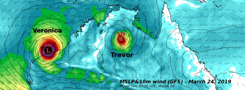
Image credit: GFS/TropicalTidbits
Tropical Cyclone "Veronica" formed north of Kimberly, Western Australia on March 19, 2019. The low rapidly intensified yesterday and BOM expects it to continue intensifying to a severe category with a severe tropical cyclone and coastal crossing possible for the Pilbara coast over the weekend.
This will be a slow-moving and intense tropical cyclone with significant and prolonged wind, storm surge and flooding impacts.
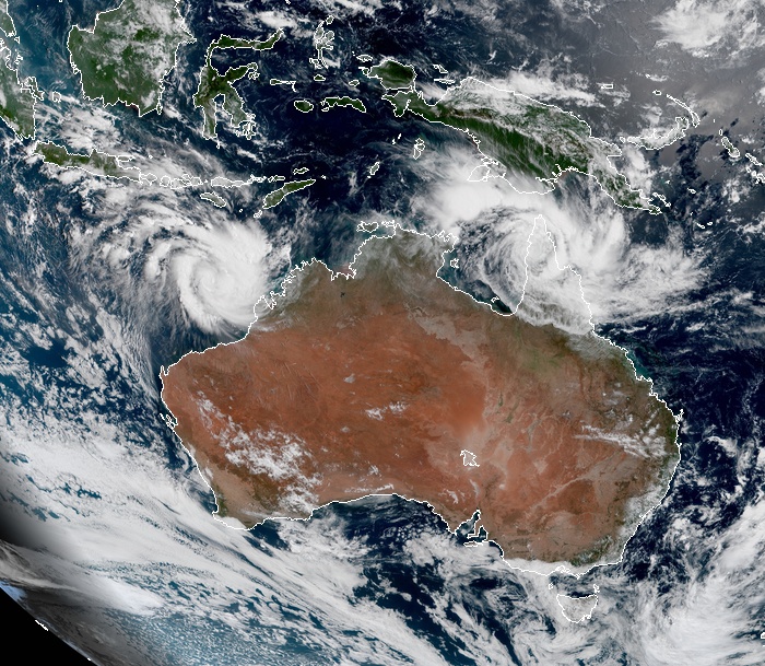
Tropical cyclones Veronica and Trevor at 00:40 UTC on March 20, 2019. Credit: JMA/Himawari-8, RAMMB/CIRA
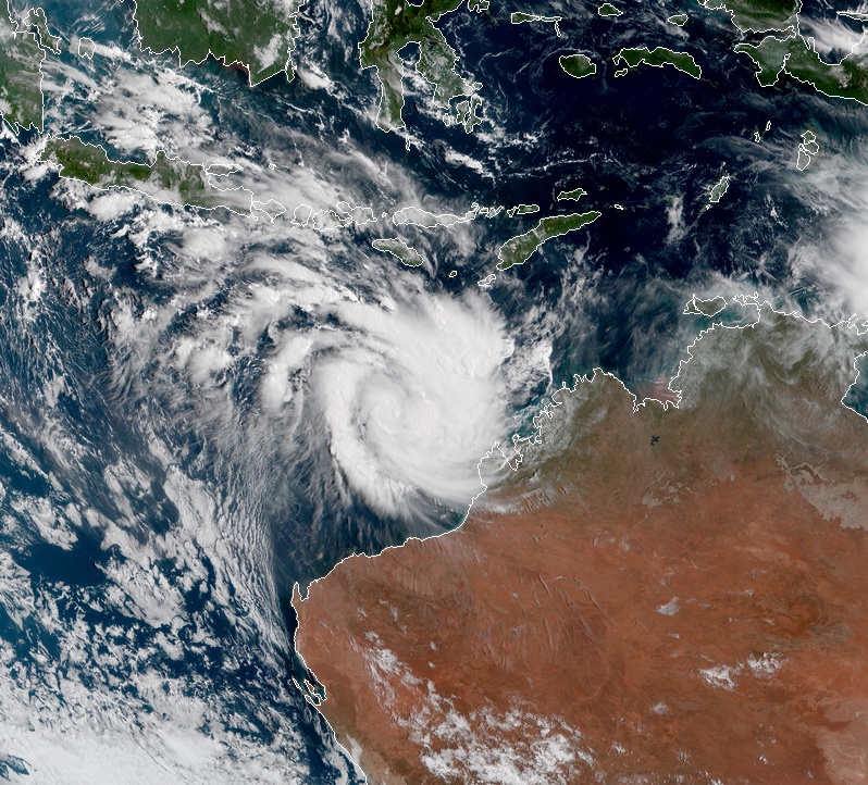
Tropical Cyclone "Veronica" at 00:40 UTC on March 20, 2019. Credit: JMA/Himawari-8, RAMMB/CIRA
There is a level of uncertainty in the exact track but communities along the Pilbara coast should begin preparing now for what could be a dangerous period over the weekend, BOM's Senior Meteorologist Andrea Peace said.
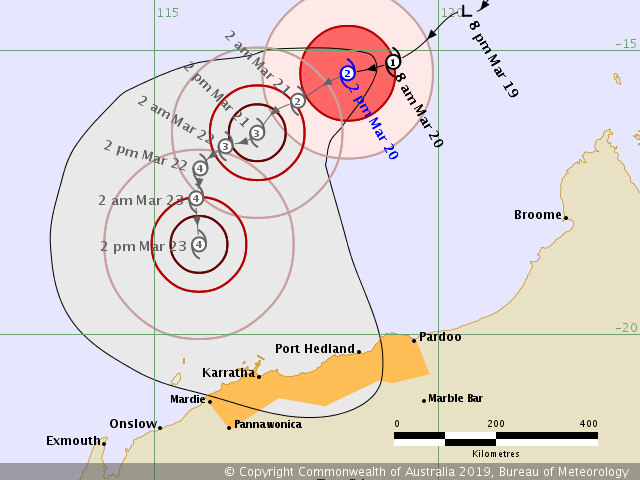
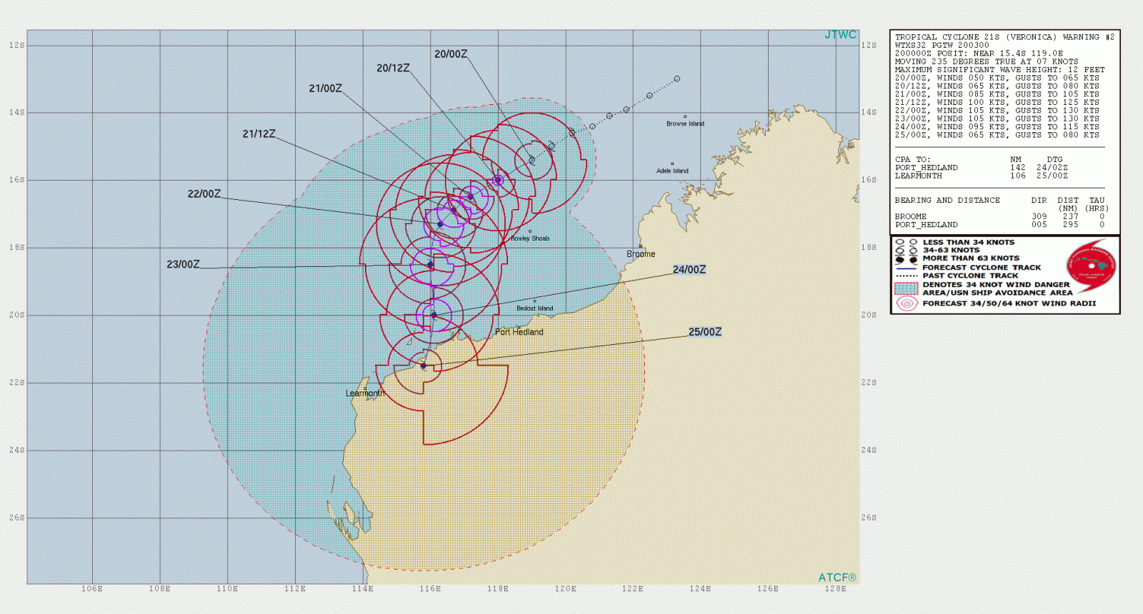
The current forecast track takes Veronica towards the WSW over the next 24 to 48 hours before taking a more southwards turn on Friday, March 22.
With very warm sea surface temperatures off the northwest coast and atmospheric conditions that are conducive to cyclone development, there's ample energy to feed this system—meaning that we can be sure that this system will intensify and gales may be experienced along the coast from Friday, although more likely overnight into Saturday, Peace said.
Communities in the Pilbara, particularly those between Port Hedland and Exmouth need to stay up to date with the latest advice from the Bureau and the Department of Fire and Emergency Services, she said.
I'm a dedicated researcher, journalist, and editor at The Watchers. With over 20 years of experience in the media industry, I specialize in hard science news, focusing on extreme weather, seismic and volcanic activity, space weather, and astronomy, including near-Earth objects and planetary defense strategies. You can reach me at teo /at/ watchers.news.
Quotes: “A very dangerous tropical cyclone” Veronica “is not far from Western Australia, get ready now.”
Theo Blashkovich March 20, 2019.
There are many conditions for the occurrence of hurricanes, but I will outline two main ones: Hurricanes occur where the water temperature is high (at least 26 degrees). This first necessary condition provides strong evaporation from the ocean surface, saturation of the vortex with water vapor. And second: a sharp temperature contrast of heated land and the cold surface of the ocean.
But the most important condition for the growth of the number of hurricanes is a global rise in the temperature of the planet. Quote: “Last year, the number of hurricanes in the world increased, and this could happen due to the fact that the temperature of the Atlantic Ocean has increased.” This conclusion was made by an international group of scientists in their study, reports Chronicle.info with reference to the news of Y.
Australia protection.
Local option. It is necessary to produce as large volumes of chilled fresh water as possible. Chilled water starts up in river sources, cools rivers, reservoirs, productive land and pastures, “old” and new forests, and coastal waters. That is, Australia performs a complete cooling of the entire region of Australia and Oceania, and brings it to the level of the 80s of the last century.
Global option: At the initiative of Australia, which is beneficial in the first place, the hottest areas on the coast of south-eastern Africa are cooled.
There is only one option for restoring the ecology and economy of Australia – there are no other options.
Sincerely, environmental programs developer, Victor Rodin. Ukraine. Khmelnitsky NPP. Tel. Kiev Star: 961336344. Mail: [email protected], [email protected]
— — —
Цитаты: «Очень опасный тропический циклон “Вероника” находится недалеко от Западной Австралии, готовьтесь сейчас».
Тео Блашкович 20 марта 2019 года.
Условий для возникновения ураганов много, но я обозначу два основных: Ураганы возникает там, где высока температура воды (не менее 26 градусов). Это первое необходимое условие обеспечивает сильное испарение с поверхности океана, насыщение вихря водяным паром. И второй: резкий температурный контраст нагретой суши и холодной поверхности океана.
Но самое главное условие роста числа ураганов – это глобальное повышение температуры планеты. Цитата: «В минувшем году в мире увеличилось количество ураганов, и произойти это могло в связи с тем, что повысилась температура Атлантического океана». К такому выводу пришла Международная группа ученых в своем исследовании, сообщает Хроника.инфо со ссылкой на Новости Ю.
Защита Австралии.
Локальный вариант. Нужно производить, как можно большие объёмы охлаждённой пресной воды. Охлаждённая вода заводится в истоки рек, охлаждает реки, водоёмы, продуктивные земли и пастбища, «старые» и новые леса, и прибрежные воды. То есть, Австралия выполняет полное охлаждение всего региона Австралия и Океания, и приводит его до уровня 80-х годов прошлого столетия.
Глобальный вариант: По инициативе Австралии, которой это выгодно в первую очередь, охлаждаются наиболее горячие участки на побережье юго-восточной Африки.
Вариант для восстановления экологии и экономики Австралии единственный – других вариантов нет.
EZEKIEL 29:11-13
Three months is 91days. 91×4 = 364 days in a jubilee year
91×40 weeks of years = 3640. Forty weeks
Daniel 9:24
52 × 7 = 364 days in a jubilee year
52 × 70 = 3640 seventy weeks.
This will end MAY 19TH AND THE NEW YEAR TRUELY STARTS MAY 1ST THUS THIS WORLD OF DARKNESS MUST NOW END AND the one of Light will begin Watchers.