Powerful winter storm to impact U.S. with heavy snow, severe thunderstorms, heavy to excessive rain and widespread strong winds
A powerful late-season winter storm will lift up into the Four Corners region on Tuesday, March 12 and then rapidly intensify across the central Plains on Wednesday, March 13, 2019. A number of hazards are expected from this powerful system: heavy snow with likely blizzard conditions, severe thunderstorms, heavy to excessive rain with an increasing flood threat across the Midwest and Mississippi Valley and widespread strong winds.
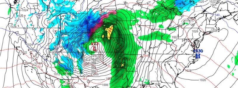
The strong mid to upper level closed low moving from northwest Mexico/Southwest U.S. Tuesday into the Southern to Central Plains Wednesday and Thursday will be the driver for a very active weather pattern over large portions of the nation over the next few days, NWS forecaster Oravec noted 07:25 UTC (03:25 EST), March 12.
Much above average levels of moisture will continue to feed northeastward ahead of this strong closed low, supporting increasingly widespread heavy precipitation affecting the Southwest, into the Southern and Central Plains, Lower to Mid Mississippi Valley and into the Great Lakes.
The heaviest precipitation totals Tuesday into Wednesday expected in the higher elevation of Arizona, southwest Colorado and stretching from northwest Texas, across Oklahoma, southeast Kansas into western Missouri.
A line of thunderstorms associated with the above-mentioned precipitation is expected to push from southeast New Mexico/Southwest Texas Tuesday evening, March 12, through much of west and central Texas Tuesday night/early Wednesday morning and then across eastern sections of the Southern Plains into the Lower to Middle Mississippi Valley Wednesday into Wednesday night/early Thursday morning.
These storms will likely produce locally heavy rains, isolated flooding and the risk of severe weather across these regions.
As the storm undergoes deepening in the lee of the Central Rockies early Wednesday, heavy snows will develop on the western edge of the storm.
Initially, this will be confined to the Central to Southern Rockies, but will spread east northeastward later Wednesday into portions of the Central to Northern Plains from northeast Colorado, eastern Wyoming, across northwest Nebraska, western to central South Dakota into southeast North Dakota and northwest Minnesota.
In addition to the heavy snows across these areas, the deepening low will result in increasing winds with blizzard conditions also possible across these areas.
Large hail, strong wind gusts, flash flooding, frequent lightning strikes and isolated tornadoes can accompany the strongest storms, AccuWeather senior meteorologist Alex Sosnowski said.
During Tuesday afternoon, severe storms may visit Lubbock, Amarillo and San Angelo, Texas, as well as Gage and Clinton, Oklahoma, he said. Major cities at risk for severe thunderstorms after dark during Tuesday night to perhaps the first thing Wednesday morning include Wichita Falls and San Antonio, Texas, as well as Oklahoma City. Storms may rumble through the Dallas metro area during Wednesday morning.
Ahead of the deepening low over the midsection nation, much above average temperatures are forecast Wednesday from eastern portions of the Plains into the Mississippi, Ohio, Tennessee Valleys and Great Lakes states.
These much above average temperatures will then spread eastward into the eastern U.S. on Thursday and remain in place for a second day from the Great Lakes into the Mississippi, Ohio and Tennessee Valleys.
To the west of this deepening low, much below average temperatures likely through the Southwest, Great Basin and Rockies on Tuesday-Wednesday and spreading into much of the Plains by Thursday.
Featured image credit: GFS, TropicalTidbits
Commenting rules and guidelines
We value the thoughts and opinions of our readers and welcome healthy discussions on our website. In order to maintain a respectful and positive community, we ask that all commenters follow these rules.