
Strong storm affecting California, flash flooding, debris flows and widespread heavy snowfall expected
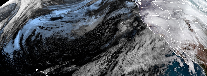
Image credit: NOAA/GOES-West. Acquired 15:30 UTC, February 13, 2019
The weather system on the West coast will interact with a deep plume of tropical moisture from near Hawaii bringing heavy rain along the central and southern Californian coast, which may produce flash flooding, and possibly debris flows near recent wildfire burn scars, NWS warns. Mountains across the West, including the Great Basin and Rocky Mountains, will receive substantial accumulations of snow.
Coastal and lower elevation rain, along with heavy mountain snow, is forecast to continue across much of the western states as multiple fronts move onshore through the end of the week, NWS forecasters Hamrick and Campbell noted at 07:58 UTC, February 13, 2019.
Conditions will be favorable for very heavy rain along the central and southern California coast and nearby mountains, which will maintain an elevated risk for flash flooding, and possible debris flows near recent wildfire burn scar areas.
A moderate to high risk area of excessive rainfall exists across much of southern California on Thursday, February 14 with a highly anomalous surge of Pacific moisture directed towards this area as part of an atmospheric river event.
Widespread heavy snowfall is expected from the Oregon Cascades to the Sierra Nevada, where 30 to 90 cm (1 to 3 feet) of snow is likely through the end of the week, and additional heavy snow is anticipated for the northern Rockies as the moisture plume moves inland, according to NWS.
"One of the more potent storms of the winter will hit California with heavy rain, excessive high country snow and gusty winds through Thursday night," AccuWeather senior meteorologist, Alex Sosnowski said.
The worst of the storm is forecast to focus on Central and Northern California with a heightened threat of flooding, mudslides, erosion, power outages and avalanches and road-closing snowfall in the mountains, Sosnowski added. Rapidly melting snow, combined with the rain can cause flooding in the short-run streams and rivers that flow out of the mountains. Motorists should anticipate small stream and urban flooding with significant delays for their commute.
As this moisture is rammed into the mountains at much lower temperatures, a tremendous amount of snow will be unleashed. Some of the ridges and peaks of the central and northern Sierra Nevada may be buried under a fresh 245 cm (8 feet) of snow from this storm alone.
"The combination of snow and wind from this new storm and the amount of snow on the steep slopes in the region will result in a high risk of avalanches," according to AccuWeather Senior Meteorologist Adam Douty.
"Interstate 80 at Donner Summit, California, is likely to be closed for a time, even though rain may mix in at the height of the storm," Douty said, adding that some of the resorts may have to close for a time.
The winter storm that has crossed the northeastern U.S. on Tuesday, February 12 is beginning to exit the East Coast, with lingering snow across much of New England on Wednesday, February 13 and lake effect snow downwind of the Great Lakes.
A band of rain with some embedded thunderstorms is expected across the coastal portion of the Southeast U.S. and Florida early on Wednesday before a cold front advects cooler and drier conditions to the region.
Another winter storm system is forecast to develop over the Upper Midwest, Great Lakes, and Northeast regions by the end of the work week as a developing surface low tracks across the region.
The corridor of snow and freezing rain with this event will be farther to the northwest compared to the most recent winter storm over the eastern U.S.
I'm a dedicated researcher, journalist, and editor at The Watchers. With over 20 years of experience in the media industry, I specialize in hard science news, focusing on extreme weather, seismic and volcanic activity, space weather, and astronomy, including near-Earth objects and planetary defense strategies. You can reach me at teo /at/ watchers.news.
Commenting rules and guidelines
We value the thoughts and opinions of our readers and welcome healthy discussions on our website. In order to maintain a respectful and positive community, we ask that all commenters follow these rules.