
California braces for another storm after historic atmospheric river claims 9 lives
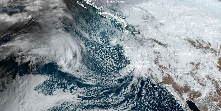
Image credit: NOAA/GOES-West, RAMMB/CIRA, The Watchers. Acquired at 17:40 UTC on February 7, 2024
California, still reeling from a historic atmospheric river that left nine people dead and hundreds of mudslides, faces a new threat from a fast-moving storm.
- NWS office in Los Angeles is urging all residents not to let the break Wednesday morning misguide them as more rain and mountain snow is coming Wednesday afternoon and night.
Following the atmospheric river’s path of destruction, which included torrential rains, flooding, and hundreds of mudslides, California is on alert as another weather system approaches. The incoming storm, expected to move into Northern California on Wednesday, February 7, promises less intensity but brings renewed concerns of additional rain and mountain snow amidst ongoing cleanup operations.
According to the FOX Forecast Center, the storm’s northern trajectory means it will not carry the same tropical moisture as its predecessor, limiting overall rain totals. However, the already saturated ground from the atmospheric river’s record-breaking downpours makes even this less intense storm a significant concern for further flooding and disruptions.
Northern California will see rain intensify during the day, with the system quickly advancing to Southern California by Wednesday evening, affecting areas like Los Angeles post-sunset. While the storm’s rapid movement and reduced moisture content may curtail total rainfall, the potential for added flooding in recently affected regions remains high.
Here are the latest details for the rest of the storm. An end is in sight, but not until Thu or Fri. Do not let the break Wednesday morning misguide you – more rain and mountain snow coming Wednesday afternoon and night. #cawx #larain pic.twitter.com/GaK8SUp63H
— NWS Los Angeles (@NWSLosAngeles) February 7, 2024
The atmospheric river, which struck California on Sunday, February 4, was noted for its exceptional severity, dropping record-breaking rain amounts and causing significant damage, including power outages and at least 475 mudslides in the Los Angeles area.
Many areas across Greater Los Angeles and beyond recorded more than 150 mm (6 inches) of rainfall — up to eight times the average for this time of year. This made it enter history books as one of the wettest storms in the history of Southern California.
“Shower and thunderstorm chances remain in the forecast for the West Coast and the Desert Southwest as a deep, energetic upper-level trough remains overhead, onshore flow continues, and another Pacific storm system drops down along the coast,” NWS forecaster Putnam said.
Active weather pattern over the EPac as captured from space. Two atmospheric rivers produced powerful winds and devastating rains to portions of the West Coast. (h/t) to our colleagues @CIRA_CSU for this amazing loop. Give them a follow for🛰 wx . #cawx #bombcyclone pic.twitter.com/K10gwtaoWm
— NWS Bay Area 🌉 (@NWSBayArea) February 7, 2024
Here are the latest quality checked rainfall totals for this storm as of 430pm.https://t.co/rmhvqyWLYD pic.twitter.com/Rh38ZNGCI4
— NWS Los Angeles (@NWSLosAngeles) February 6, 2024
“While the influx of anomalously high moisture associated with this past weekend’s Atmospheric River has ended, moderate to locally heavy rainfall on top of the very wet antecedent conditions may still bring a risk for some isolated instances of flooding, particularly along coastal central and Southern California Wednesday and along the Mogollon Rim of Arizona through Thursday,” Putnam said.
Higher elevations of the Sierra Nevada and Transverse/Peninsular Ranges will see some additional heavy snowfall totals of around 150 – 300 mm (6 – 12 inches), while the Cascades and northern Coastal Ranges of California will see some light to moderate snow.
References:
1 Fast-moving storm threatens California one day after deadly atmospheric river exits – FOX Weather – February 7, 2024
2 Here’s how much it has rained in California – Los Angeles Times – February 6, 2024
3 Los Angeles records 475 mudslides during historic storm that has drenched Southern California – AP – February 7, 2024
4 Short Range Forecast Discussion – NWS Weather Prediction Center College Park MD – 259 AM EST Wed Feb 07 2024
The Watchers team and our contributors bring the latest on extreme weather, earthquakes, volcanic eruptions, space weather, and all things science. We're all about making sense of the natural world and keeping you informed on what’s happening. Got a tip or a question? Hit us up using the form at newstips!
Commenting rules and guidelines
We value the thoughts and opinions of our readers and welcome healthy discussions on our website. In order to maintain a respectful and positive community, we ask that all commenters follow these rules.