
Major winter storm to impact the Central and Eastern U.S. through this weekend
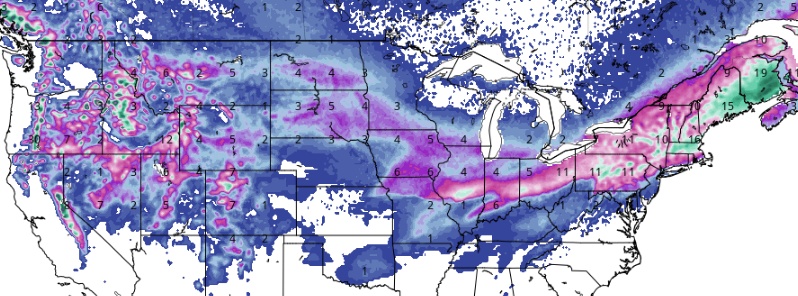
Featured image: GFS Total Snowfall for January 20, 2019. Model run 06:00 UTC, January 18. Credit: GFS, TropicalTidbits.com
An impactful Pacific storm will move east and redevelop into a significant winter storm, NWS warns. Heavy snow to the north of this storm and heavy rain to the south with freezing rain at the junction will form over the Central U.S. Friday, January 18, 2019. This system shifts into the Eastern States on Saturday, January 19 with heavy snow from the Midwest to the Northeast, and heavy rain from the Mid-South to the Mid-Atlantic.
A major winter storm is expected to move rapidly across the Midwest into New England during this weekend, NWS forecaster Kong noted in Short Range Forecast Discussion issued 08:15 UTC (03:15 EST), January 18, 2019.
A low pressure system that has been tracking across the Pacific and then the western U.S. for the past few days is about to exit the Rockies into the central Plains.
The low pressure system will be re-energized over the Plains as it merges with a strong surge of arctic air from Canada.
Snow combined with very strong winds will spread across the Midwest and parts of the central Plains on Saturday, January 19.
As the storm intensifies further on Saturday night, heavy snow is forecast to develop and rapidly overspread the Ohio Valley, reaching much of New England early on Sunday.
The storm is expected to become quite intense on Sunday, January 20 as its center passes near or just south of New York City. Conditions over interior New England could approach blizzard criteria as the storm brings very strong northerly winds together with heavy snow.
Near and to the south of the storm track, much milder air from the south will keep the precipitation as rain. Over the Deep South, strong to possibly severe thunderstorms are forecast for Saturday from the lower Mississippi Valley eastward as a strong cold front approaches.
In the wake of the storm, an arctic surface high will plunge southward from Canada and result in frigid temperatures across the Plains and the Upper Midwest, with temperature departures on the order of 8 – 14 °C (15 to 25 °F) below normal.
Meanwhile, mountain snows across the central and southern Rockies associated with the exiting low pressure system are expected to gradually taper off today.
However, more energetic low pressure systems and associated fronts are forecast to reach the Pacific Northwest, bringing heavy precipitation and gusty winds across the region on Saturday.
The precipitation is expected to shift further to the south across Oregon and northern California Saturday night into early on Sunday.
"Difficult to dangerous travel conditions will unfold from parts of the Plains to portions of the Great Lakes and Ohio Valley as the major storm moves from west to east across the region from Friday to Saturday night," AccuWeather senior meteorologist Alex Sosnowski noted.
"Motorists will be at risk for getting stuck on the highways, and airline passengers may spend hours at airports due to mounting airline delays and flight cancellations. Unnecessary travel should be avoided during the storm, due to the risk of being stranded in your vehicle in plummeting temperatures."
The Weather Channel named this storm Harper. You can read their report at the following link: Winter Storm Harper at TWC.
I'm a dedicated researcher, journalist, and editor at The Watchers. With over 20 years of experience in the media industry, I specialize in hard science news, focusing on extreme weather, seismic and volcanic activity, space weather, and astronomy, including near-Earth objects and planetary defense strategies. You can reach me at teo /at/ watchers.news.
Commenting rules and guidelines
We value the thoughts and opinions of our readers and welcome healthy discussions on our website. In order to maintain a respectful and positive community, we ask that all commenters follow these rules.