
Strong and shallow M6.1 earthquake hits Iran, second M6+ of the day
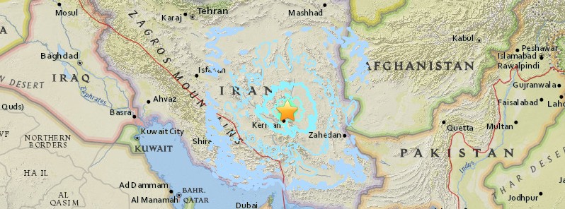
Image credit: USGS
A strong and shallow earthquake registered by the IRSC as M6.1 hit southeastern Iran at 21:41 UTC on December 12, 2017 (01:11 local time, December 13). The agency is reporting a depth of 10 km (6.2 miles). The USGS is reporting M6.0 at a depth of 10 km. EMSC initially reported M6.2 (automatic via GFZ) and downgraded to M6.1 at a depth of 14 km (8.7 miles).
This is the second M6+ earthquake to hit this region of Iran today. It comes 12 hours after M6.2 at 08:43 UTC. Numerous aftershocks are shaking the region.
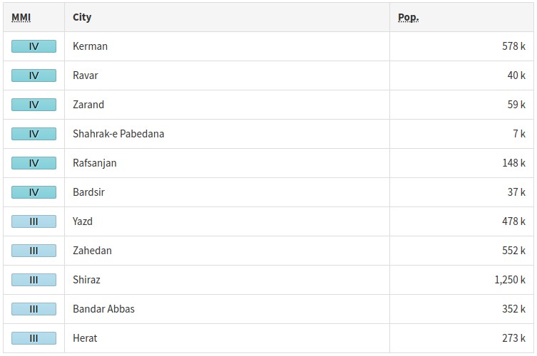
According to the USGS, the epicenter was located 64.2 km (39.9 miles) NNE of Kermān (population 577 514), 65.2 km (40.5 miles) SE of Rāvar (population 40 167), 67.9 km (42.2 miles) E of Zarand (population 58 983), and 121.6 km (75.6 miles) NNE of Bardsīr (population 37 192), Iran.
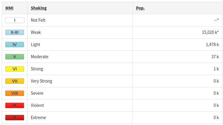
There are 890 000 people living within 100 km (62 miles).
1 000 people are estimated to have felt strong shaking, 37 000 moderate and 1 478 000 light, according to the USGS.
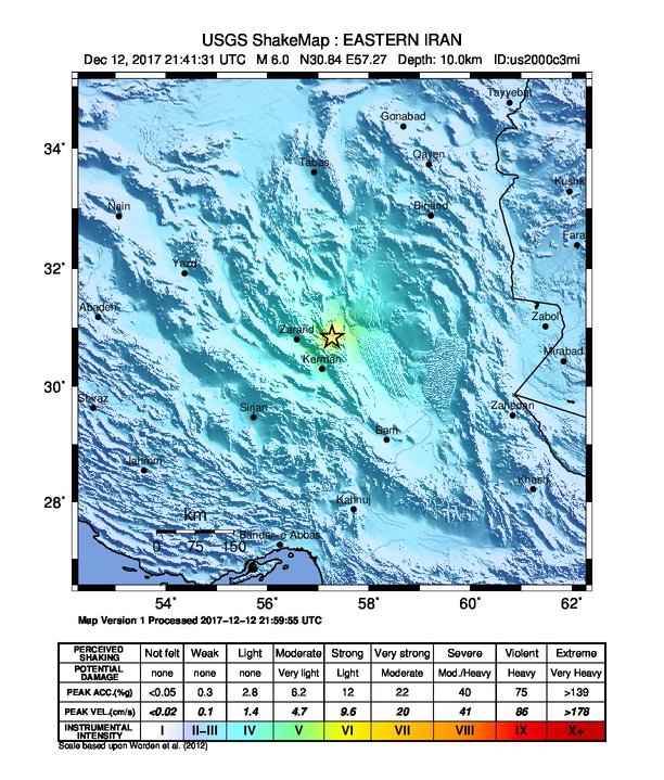
A green alert was issued for shaking-related fatalities and economic losses. There is a low likelihood of casualties and damage.
Overall, the population in this region resides in structures that are extremely vulnerable to earthquake shaking, though some resistant structures exist. The predominant vulnerable building types are informal (metal, timber, GI etc.) and adobe block construction.
Recent earthquakes in this area have caused secondary hazards such as landslides that might have contributed to losses.
Update
December 13
At least 58 people were injured as they ran out of their homes, ISNA reports. At least 20 buildings were damaged.
Estimated population exposure to earthquake shaking

Selected cities exposed
Regional seismicity
.jpg)
Seismotectonics of the Middle East and vicinity
No fewer than four major tectonic plates (Arabia, Eurasia, India, and Africa) and one smaller tectonic block (Anatolia) are responsible for seismicity and tectonics in the Middle East and surrounding region. Geologic development of the region is a consequence of a number of first-order plate tectonic processes that include subduction, large-scale transform faulting, compressional mountain building and crustal extension.
Mountain building in northern Pakistan and Afghanistan is the result of compressional tectonics associated with collision of the India plate moving northwards at a rate of 40 mm/yr with respect to the Eurasia plate. Continental thickening of the northern and western edge of the India subcontinent has produced the highest mountains in the world, including the Himalayan, Karakoram, Pamir and Hindu Kush ranges. Earthquake activity and faulting found in this region, as well as adjacent parts of Afghanistan and India, are due to collisional plate tectonics.
Beneath the Pamir-Hindu Kush Mountains of northern Afghanistan, earthquakes occur to depths as great as 200 km as a result of remnant lithospheric subduction. Shallower crustal earthquakes in the Pamir-Hindu Mountains occur primarily along the Main Pamir Thrust and other active Quaternary faults, which accommodate much of the region's crustal shortening. The western and eastern margins of the Main Pamir Thrust display a combination of thrust and strike-slip mechanisms.
Along the western margin of the Tibetan Plateau, in the vicinity of southeastern Afghanistan and western Pakistan, the India plate translates obliquely relative to the Eurasia plate, resulting in a complex fold-and-thrust belt known as the Sulaiman Range. Faulting in this region includes strike-slip, reverse-slip and oblique-slip motion and often results in shallow, destructive earthquakes. The relatively fast moving left-lateral, strike-slip Chaman Fault system in southeastern Afghanistan accommodates translational motion between the India and Eurasia plates. In 1505, a segment of the Chaman Fault system near Kabul, Afghanistan ruptured causing widespread destruction of Kabul and surrounding villages. In the same region, the more recent 30 May 1935, M7.6 Quetta, Pakistan earthquake, occurred within the Sulaiman Range, killing between 30,000 and 60,000 people.
Off the south coast of Pakistan and southeast coast of Iran, the Makran trench is the present-day surface expression of active subduction of the Arabia plate beneath the continental Eurasia plate, which converge at a rate of approximately 20 mm/yr. Although the Makran subduction zone has a relatively slow convergence rate, it has produced large devastating earthquakes and tsunamis. For example, the November 27, 1945 M8.0 mega-thrust earthquake produced a tsunami within the Gulf of Oman and Arabia Sea, killing over 4,000 people. Northwest of this active subduction zone, collision of the Arabia and Eurasia plates forms the approximately 1,500-km-long fold and thrust belt of the Zagros Mountains, which crosses the whole of western Iran and extends into northeastern Iraq. Collision of the Arabia and Eurasia plates also causes crustal shortening in the Alborz Mountains and Kopet Dag in northern Iran. Eastern Iran experiences destructive earthquakes that originate on both strike-slip and reverse faults. For example, the 16 September 1978 M7.8 earthquake, along the southwest edge of the Dasht-e-Lut Basin killed at least 15,000 people.
Along the eastern margin of the Mediterranean region there is complex interaction between the Africa, Arabia and Eurasia plates. The Red Sea Rift is a spreading center between the Africa and Arabia plates, with a spreading rate of approximately 10mm/yr near its northern end, and 16mm/yr near its southern end (Chu, D. and Gordon, R. G., 1998). Seismicity rate and size of earthquakes has been relatively small along the spreading center, but the rifting process has produced a series of volcanic systems across western Saudi Arabia.
Further north, the Red Sea Rift terminates at the southern boundary of the Dead Sea Transform Fault. The Dead Sea Transform is a strike-slip fault that accommodates differential motion between the Africa and Arabia plates. Though both the Africa plate, to the west, and the Arabia plate, to the east, are moving in a NNE direction, the Arabia plate is moving slightly faster, resulting in the left-lateral, strike-slip motion along this segment of the plate boundary. Historically, earthquake activity along the Dead Sea Transform has been a significant hazard in the densely populated Levant region (eastern Mediterranean). For example, the November 1759 Near East earthquake is thought to have killed somewhere between 2,000-20,000 people. The northern termination of the Dead Sea Transform occurs within a complex tectonic region of southeast Turkey, where interaction of the Africa and Arabia plates and the Anatolia block occurs. This involves translational motion of the Anatolia Block westwards, with a speed of approximately 25mm/yr with respect to Eurasia, in order to accommodate closure of the Mediterranean basin.
The right-lateral, strike-slip North Anatolia Fault, in northern Turkey, accommodates much of the westwards motion between the Anatolia Block and Eurasia Plate. Between 1939 and 1999, a series of devastating M7.0+ strike-slip earthquakes propagated westwards along the North Anatolia Fault system. The westernmost of these earthquakes was the 17th August 1999, M7.6 Izmit earthquake, near the Sea of Marmara, killed approximately 17,000 people.
At the southern edge of the Anatolia Block lies the east-west trending Cyprian Arc with associated levels of moderate seismicity. The Cyprian Arc represents the convergent boundary between the Anatolia Block to the north and the Africa Plate to the south. The boundary is thought to join the East Anatolia Fault zone in eastern Turkey; however no certain geometry or sense of relative motion along the entire boundary is widely accepted. (USGS)
I'm a dedicated researcher, journalist, and editor at The Watchers. With over 20 years of experience in the media industry, I specialize in hard science news, focusing on extreme weather, seismic and volcanic activity, space weather, and astronomy, including near-Earth objects and planetary defense strategies. You can reach me at teo /at/ watchers.news.
Commenting rules and guidelines
We value the thoughts and opinions of our readers and welcome healthy discussions on our website. In order to maintain a respectful and positive community, we ask that all commenters follow these rules.