
Tropical Storm “Cindy” forms, heavy rain spreading across central Gulf Coast
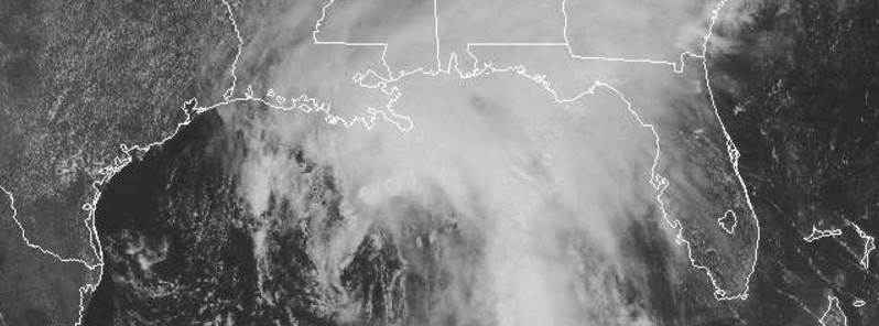
Featured image: Tropical Storm "Cindy" at 17:15 UTC on June 20, 2017. Credit: NOAA/GOES
Potential Tropical Cyclone Three has acquired a well-defined center today and at 18:00 UTC it officially became Cindy, the third named tropical cyclone of the 2017 Atlantic hurricane season. Heavy rain produced by this system is spreading across much of the central Gulf Coast. Cindy is expected to approach the coast of southwest Louisiana late Wednesday or Wednesday night (local time), June 21, and move inland over western Louisiana and eastern Texas on Thursday, June 22, 2017.
At 18:00 UTC (13:00 CDT) on June 20, the center of Tropical Storm "Cindy" was located about 430 km (265 miles) south of Morgan City, Louisiana and 565 km (355 miles) southeast of Galveston, Texas. Its maximum sustained winds were reaching 75 km/h (45 mph). Cindy is currently a stationary system with minimum estimated central pressure of 999 hPa, according to NHC.
The system is expected to resume motion toward the northwest at around 17 km/h (10 mph) later today, and this motion is expected to continue through Wednesday night. A turn toward the north-northwest is expected early Thursday, June 22.
On the current forecast track, Cindy is expected to approach the coast of southwest Louisiana late Wednesday or Wednesday night (local time), June 21, and move inland over western Louisiana and eastern Texas on Thursday.
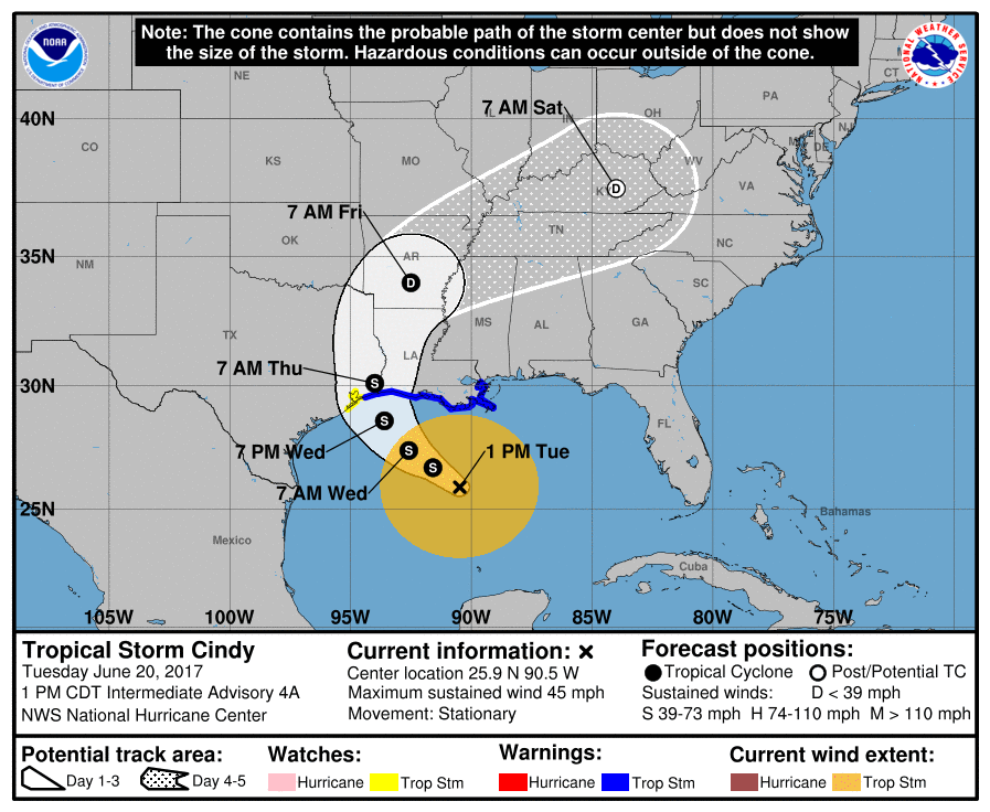
A Tropical Storm Warning is in effect for High Island to the mouth of Pearl River.
A Tropical Storm Watch is in effect for West of High Island to San Luis Pass.
Tropical storm conditions are expected to first reach the coast within the warning area later today and spread westward within the warning area through Wednesday. Tropical storm conditions are possible in the watch area on Wednesday.
Tropical Storm #Cindy has formed in the Gulf of Mexico. Rainfall is the primary hazard with maximum totals to 12" https://t.co/Iqeygf0LEO pic.twitter.com/Vm3ADLk4xj
— NHC Atlantic Ops (@NHC_Atlantic) June 20, 2017
Cindy is expected to produce total rain accumulations of 152.4 to 228.6 mm (6 to 9 inches) with isolated maximum amounts of 304.8 mm (12 inches) over southeastern Louisiana, southern Mississippi, southern Alabama, and the Florida Panhandle through Thursday. Rainfall amounts of 76.2 to 127 mm (3 to 5 inches) with isolated maximum amounts of 152.4 mm (6 inches) can be expected farther west across southwest Louisiana into southeast Texas through Thursday.
Inundation of 30 to 90 cm (1 to 3 feet) above ground level is possible along the coast in portions of the Tropical Storm Warning area.
A tornado or two is possible this afternoon and tonight from south-central Louisiana to the western Florida Panhandle.
I'm a dedicated researcher, journalist, and editor at The Watchers. With over 20 years of experience in the media industry, I specialize in hard science news, focusing on extreme weather, seismic and volcanic activity, space weather, and astronomy, including near-Earth objects and planetary defense strategies. You can reach me at teo /at/ watchers.news.
Commenting rules and guidelines
We value the thoughts and opinions of our readers and welcome healthy discussions on our website. In order to maintain a respectful and positive community, we ask that all commenters follow these rules.