
Category 4 Hurricane “Ida” hits Louisiana on Katrina’s 16th anniversary, leaves more than 1 million homes without power
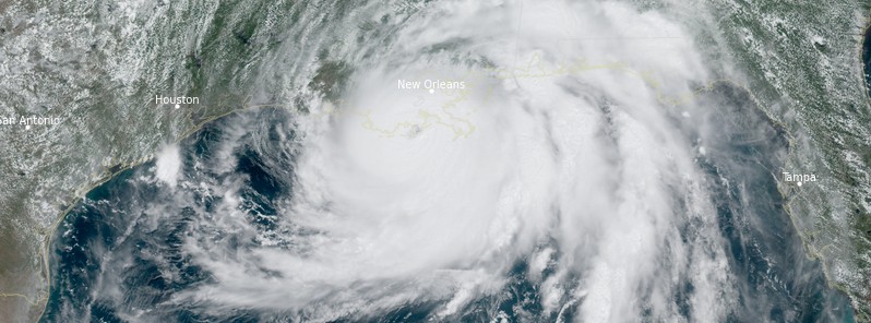
Featured image: Hurricane "Ida" at 17:00 UTC on August 29, 2021. Credit: NOAA/GOES-East, RAMMB/CIRA, TW
Extremely dangerous Category 4 Hurricane "Ida" made landfall in Louisiana, U.S. on August 29, 2021, bringing catastrophic storm surge, maximum sustained winds of 240 km/h (150 mph), and heavy rains.
- More than 1 million customers in Louisiana were left without power, including the entire city of New Orleans.
- At least 1 person was killed after a tree fell on his home in Ascension Parish.
- The storm hit on the 16th anniversary of the devastating Hurricane "Katrina."
- Ida is the second most intense hurricane on record to hit Louisiana, only behind Katrina. It tied for the strongest landfall in the state by maximum winds with Hurricane "Laura" in 2020 and the 1856 Last Island hurricane.
- A relatively rare Brown Ocean Effect kept Ida's eyewall intact hours after landfall.
Ida rapidly intensified into a Category 4 hurricane at 07:00 UTC on August 29, with maximum sustained winds of 215 km/h (130 mph) and a minimum central pressure of 949 hPa.
By 11:00 UTC, Ida had maximum sustained winds of 240 km/h (150 mph) and a minimum central pressure of 935 hPa. At the time, it was 120 km (75 miles) SE of Grand Isle, Louisiana, and 95 km (60 miles) SSW of the mouth of the Mississippi River.
Life-threatening storm surge and hurricane-force winds started reaching the coast of southeastern Louisiana by 12:00 UTC. While maximum sustained winds remained at 240 km/h, Ida's central pressure dropped to 933 hPa and to 930 hPa by 13:00 UTC (08:00 CDT).
Catastrophic storm surge and hurricane-force winds were moving onshore by 15:00 UTC and by 16:00 UTC Ida's northern eyewall started moving onshore along the coast of southeastern Louisiana. Maximum sustained winds remained at 240 km/h and minimum central pressure at 933 hPa.
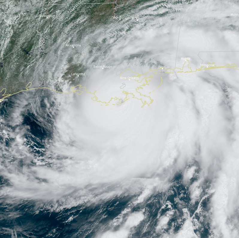
NOAA Doppler radar imagery indicated that the eye of Ida made landfall along the coast of Louisiana near Port Fourchon around 16:55 UTC (11:55 CDT) with maximum sustained winds of 240 km/h and (150 mph) and minimum central pressure at 930 hPa, making it a Category 4 hurricane on the Saffir-Simpson Hurricane Wind Scale.
Just before landfall, a NOAA National Ocean Service tide gauge in Shell Beach, Louisiana, reported a water level of 1.9 m (6.4 feet) above mean higher high water, which is an approximation of inundation in that area. A tide gauge at Bay Waveland Yacht Club, Mississippi, reported a water level of 1.6 m (5.5 feet) above mean higher high water, which is an approximation of inundation in that area.1
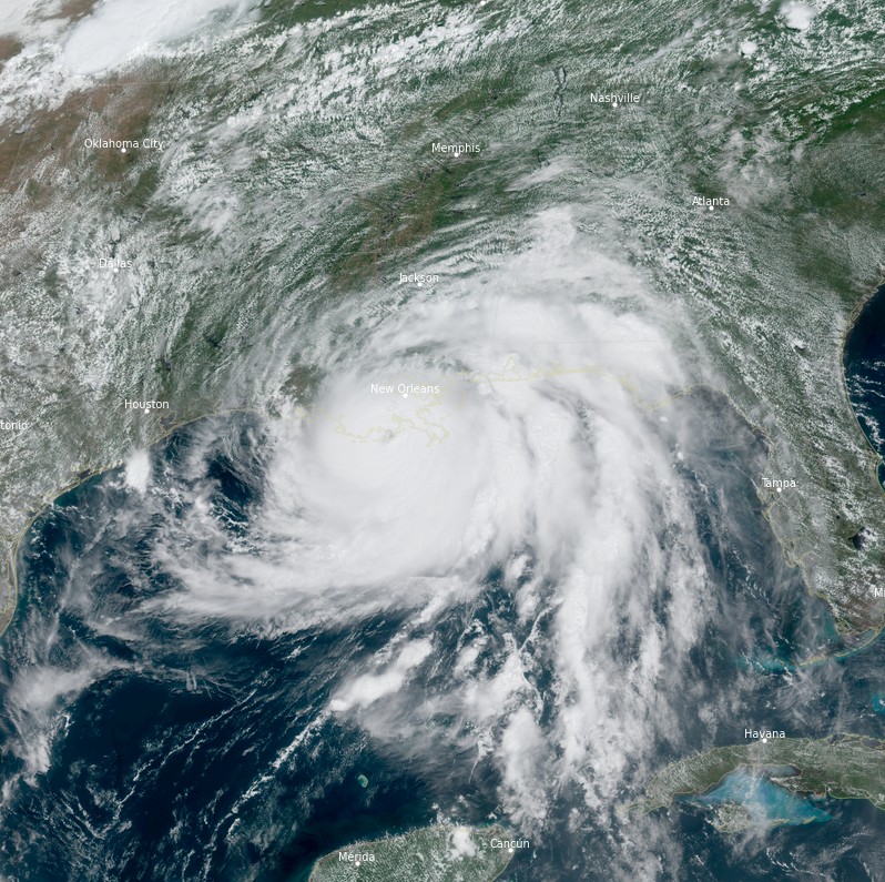
Hurricane "Ida" at 17:00 UTC on August 29, 2021. Credit: NOAA/GOES-East, RAMMB/CIRA, TW
Ida made second landfall southwest of Galliano, Louisiana at 19:00 UTC with maximum sustained winds of 235 km/h (145 mph) and a minimum central pressure of 934 hPa.
By 20:00 UTC (15:00 CDT), Ida's center was about 30 km (20 miles) SE of Houma, Louisiana. The storm was only slightly weaker, with maximum sustained winds of 225 km/h (140 mph) and a minimum central pressure of 937 hPa.
Catastrophic storm surge, extreme winds, and flash flooding continued in parts of southeastern Louisiana as Ida moved NW at 17 km/h (10 mph) at 21:00 UTC. At 23:00 UTC, maximum sustained winds dropped to 200 km/h (125 mph) and minimum central pressure rose to 941 hPa — Category 3 hurricane.
At 01:00 UTC on August 30 (20:00 CDT, August 29), Ida's eye was passing just west of New Orleans with maximum sustained winds of 185 km/h (115 mph) and a minimum central pressure of 947 hPa.
Maximum sustained winds dropped to 155 km/h (95 mph) and minimum central pressure rose to 960 hPa by 04:00 UTC — Category 2 hurricane. At the time, the center was located about 10 km (6 miles) W of Killian, 50 km (31 miles) ESE of Baton Rouge, and 70 km (45 miles) NW of New Orleans, Louisiana.
Ida weakened into a tropical storm by 09:00 UTC, 155 km (95 miles) SSW of Jackson, Mississippi, and 75 km (50 miles) NNE of Baton Rouge, Louisiana.
The hurricane left more than 1 million customers without power in Louisiana (45% of the state), including the entire city of New Orleans (population 390 845).
"Hurricane Ida’s intensity has caused catastrophic damage in its path, including a load imbalance to the company’s transmission and generation," Entergy New Orleans said.
A rare flash flood emergency was issued Sunday night for the south shore area of metro New Orleans. City authorities said water had begun spilling out of Lake Ponchartrain so fast that there was no time to organize a mandatory evacuation of the city.
Another rare flash flood emergency was issued for Jean Lafitte and Lafitte where major damage was reported, including a collapsed bridge and overtopped levees. Emergency services said they were unable to conduct rescues, saying rescue boats will be deployed as soon as the weather permits. A small rescue team was deployed for those in immediate and/or imminent danger.2
According to the Louisiana Department of Health, a 60-year-old man was killed in Ascension Parish on Sunday after a tree struck his home.
Storm surge and strong winds stopped the flow of the Mississippi River on Sunday near New Orleans and actually caused the flow to reverse – something the United States Geological Survey said is 'extremely uncommon.'3
"I remember, offhand, that there was some flow reversal of the Mississippi River during Hurricane Katrina, but it is extremely uncommon," Scott Perrien, a supervising hydrologist with the USGS Lower Mississippi Gulf Water Science Center in Baton Rouge, Louisiana, told CNN.
Perrien noted that the river level rose about 2.1 m (7 feet) due to the storm surge pushing up the river at the USGS gauge, located in Belle Chasse, about 32 km (20 miles) south of New Orleans in southeastern Louisiana.
"During that time, the flow of the river slowed from about 0.6 m (2 feet) per second down to about 0.15 m (0.5 feet) per second in the other direction," Perrien said.
A relatively rare Brown Ocean Effect kept Ida's eyewall intact hours after landfall.
According to NASA-funded research, three conditions must be met in order for the brown ocean effect to take place. First, the lower level of the atmosphere mimics a tropical atmosphere with minimal variation in temperature. Second, soils in the vicinity of the storms need to contain ample moisture. Finally, evaporation of the soil moisture releases latent heat, which the team found must measure at least 70 watts averaged per square meter.4
Tennessee Emergency Management Agency is warning Ida could trigger immense flooding in the state, including the same areas that are still recovering from last week’s tragic flooding.5
At 12:00 UTC on August 29, the center of Tropical Storm "Ida" was located about 105 km (65 miles) SSW of Jackson, Mississippi. The storm had maximum sustained winds of 75 km/h (45 mph) and a minimum central pressure of 993 hPa. It was moving N over southwestern Mississippi at 13 km/h (8 mph).
Dangerous storm surge and flash flooding continue over portions of southeastern Louisiana, southern Mississippi and southern Alabama.
As of 12:20 UTC, 1 023 060 customers in Louisiana are without power and 110 968 in Mississippi.
References:
1 Hurricane Ida Advisory Archive – NHC
2 LIVE: New Orleans without power following 'catastrophic transmission damage' – AccuWeather
3 Hurricane Ida makes landfall in Louisiana 08 29 21 – CNN
4 'Brown Ocean' Can Fuel Inland Tropical Cyclones – NASA
5 Catastrophic flooding hits Tennessee after record rainfall, leaving at least 22 people dead and dozens missing – The Watchers
I'm a dedicated researcher, journalist, and editor at The Watchers. With over 20 years of experience in the media industry, I specialize in hard science news, focusing on extreme weather, seismic and volcanic activity, space weather, and astronomy, including near-Earth objects and planetary defense strategies. You can reach me at teo /at/ watchers.news.
Commenting rules and guidelines
We value the thoughts and opinions of our readers and welcome healthy discussions on our website. In order to maintain a respectful and positive community, we ask that all commenters follow these rules.