Rare, winter-like June storm hits Northern California
A rare, winter-like June storm hit Northern California early Sunday afternoon, June 11, 2017, bringing sharp temperatures drop, heavy rain, hail, frequent lightning, and even snow in some higher elevations. The weather is expected to clear up by Monday morning, but overnight low temperatures in Sierra could stay below freezing for as many as 2 to 3 more nights, NWS said.
NWS meteorologist Will Pi said the system powered up early Sunday afternoon as a line of thunderstorms developed over central Napa County. "The storms materialized along a line that stretched from roughly Santa Rosa to Calistoga and began moving south toward Solano County from there," he said.
According to Pi, this chaotic weather system is the result of low pressure and cold temperatures in the upper atmosphere that mingled with the relatively warm surface temperatures to create a very unstable air mass.
"It’s rare for this time of year," Pi said. "Sometimes you see it in April and May."

As expected, snow began falling in parts of the Sierra Nevada and NWS said they expect up to 12.7 cm (5 inches) in higher elevations of the Northern Sierra, with possibly 20 – 30 cm (8 to 12 inches) of snow falling over Lassen Volcanic National Park.
Meteorologist Eric Kurth said it’s not uncommon to get snow in the mountain peaks this time of year, but it’s unusual for the weather service to issue an advisory in June warning drivers to be ready for winter driving conditions.
In the Bay Area, thunder, lightning, hail and rain were seen in areas of the North Bay and expected to taper off by Monday morning.
The NWS Sacramento said they received several reports of funnel clouds but none of them ever touched down.
Storms continue to develop across the area. Small hail will be possible with them. #CAwx pic.twitter.com/sXUveGhB3w
— NWS Sacramento (@NWSSacramento) June 11, 2017
Another shot of funnel cloud in Plumas Lake. Dissipated but tons of thunder, lightning, hail, and rain #sacwx #cawx @kcraFinan pic.twitter.com/AeLCl292YW
— Gary Bradford (@YubaSupBradford) June 11, 2017
@kcraFinan funnel cloud near Lincoln, CA 2 mins ago. Reminded me of my OKlahoma days. pic.twitter.com/1QPNJVZ3Cf
— Eric Clark (@ercla) June 11, 2017
Not a view you expect to see in June ❄️ Webcams show #snow falling on I-80! Expect accumulating snow overnight. #cawx pic.twitter.com/7PsCwdJQQq
— NWS Sacramento (@NWSSacramento) June 12, 2017
A lot of hail accumulating near Garden Valley, CA! #CAwx Photo Credit: Ed Riolino @NWSSacramento @kcraFinan pic.twitter.com/idQcLr6OxQ
— Andy Moffitt (@weatherprophet) June 12, 2017
#TrafficAlert Snowing on Donner Pass and cold temps means icy conditions. Prepare for winter driving conditions and take it slow. pic.twitter.com/FuIo45WqE3
— Caltrans District 3 (@CaltransDist3) June 12, 2017
Winter is coming. The view of Sierra weather at 3:22 pm Sunday June 11th, 2017. views from @squawalpine #CAwx #Juneuary pic.twitter.com/3vTH7ldsfK
— Rob Mayeda (@RobMayeda) June 11, 2017
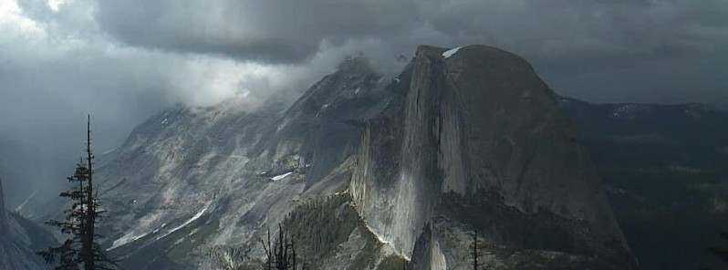
Storm shadows over Yosemite via @YoseConservancy #CAwx #CAStorm pic.twitter.com/2z3S7NSAaJ
— Rob Mayeda (@RobMayeda) June 12, 2017
"A strong storm will keep winter-like conditions across the Sierra and western Nevada through Monday with high temperatures as much as 25 °F (13.8 °C) below normal," NWS Reno, Nevada said Sunday. "With rain and snow showers and breezy winds, the temperatures will feel downright frigid for June, especially in areas of overcast skies."
Overnight low temperatures in the Sierra could stay below freezing for as many as 2 to 3 more nights, it added. While most of the lower valleys of western Nevada are not expected to experience freezing early morning temperatures through Monday, lows in the coldest valleys will fall into the mid-30s (~1.7 °C) Monday morning. Therefore, anyone with sensitive vegetation in the colder valleys should take the necessary precautions.
Accumulating snow will be possible in the Sierra above 1 800 m (6 000 feet) late through early Monday morning, with 5 – 13 cm (2 – 5 inches) of snow possible in the higher elevations above 2 130 m (7 000 feet). In northeast California and northwestern Nevada, 10 – 20 cm (4 – 8 inches) is possible above 1 980 m (6 500 feet), with a couple inches down to 1 670 – 1 830 m (5 500 to 6 000 feet). Mountains in western Nevada could also see several inches of snow accumulation, with up to an inch for locations such as the Virginia City Highlands.
With the June Sun angle, snow will melt off rapidly with impacts to mountain passes limited to the overnight hours. However, even a short burst of accumulating snow can cause a significant travel hazard, so slow down if you end up in any snow showers.
Featured image: Storm shadows over Yosemite, June 11, 2017. Credit: Yosemite Conservancy (via Rob Mayeda)
Commenting rules and guidelines
We value the thoughts and opinions of our readers and welcome healthy discussions on our website. In order to maintain a respectful and positive community, we ask that all commenters follow these rules.