
Extreme rainfall over South Florida leaves widespread flooding
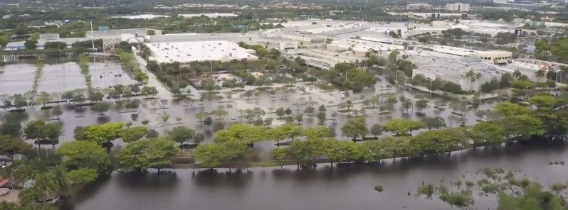
Featured image: Sawgrass Mill flooding, South Florida - June 2017. Credit: KWCPhotography
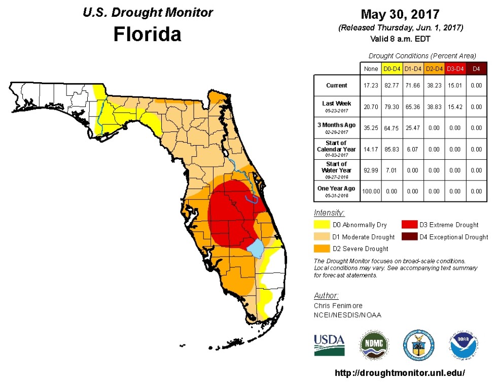
Most of South Florida is in a severe drought condition, but just several days of heavy rain turned out to be sufficient for widespread flooding. The rain is coming in waves and it seems the region will not be out of it at least until Saturday, June 10, 2017.
What was left of deadly Tropical Storm "Beatriz" after it dumped heavy rain over Mexico late last week interacted with a storm dropping out of the Southern Plains, causing a drastic increase of the moisture in the atmosphere over South Florida.
"With the moisture in place and the weather pattern setup the way it is, rainfall is developing over the same region and moving over the same areas day after day. Initially, this area where the rain was focused was along Alligator Alley putting tremendous amounts of rain down from Naples east to Fort Lauderdale. After three days of rain, amounts close to a 1 foot (305 mm) have been reported mainly across the Gulf Coast," Dave Warren of CBS Miami said.
According to data provided by NASA/JAXA Global Precipitation Mission (GPM), southeastern Florida received over 482 mm (19 inches) between June 1 and 7. Record rainfall has been reported in Fort Lauderdale and West Palm, leading to flooding and flight cancellations. As of 12:00 local time Wednesday, Fort Lauderdale-Hollywood International Airport had 237 delays and 23 cancellations, while Miami International Airport had 47 delays and 26 cancellations.
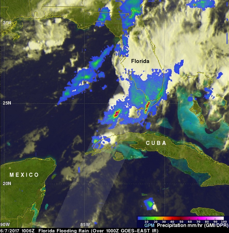
Image credit: NASA/JAXA GPM
The GPM core observatory satellite flew above southern Florida on June 7, 2017 at 10:06 UTC (06:06 EDT), revealing the intensity of rainfall within powerful storms that were drenching southern Florida. GPM's DPR instrument measured rain falling at a rate of over 190.5 mm (7.5 inches) in one powerful storm in the Gulf Of Mexico west of the Florida Keys.
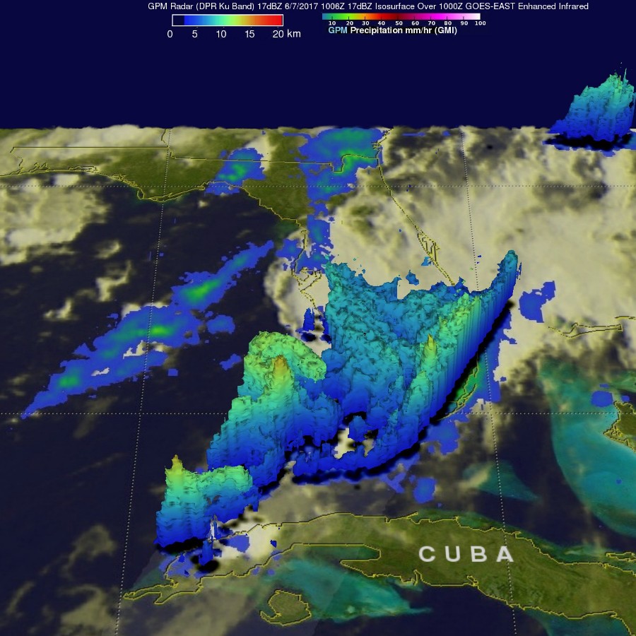
Image credit: NASA/JAXA GPM
A 3-D view of the vertical structure in these extraordinary storms was developed from GPM Radar (DPR Ku Band) data. Those data showed that several thunderstorm tops were reaching altitudes of 15 km (9.3 miles). The most powerful storms were found to have tops that were reaching above 15.37 km (9.5 miles). A few extremely heavy downpours were measured returning radar reflectivity values of almost 61 dBZ to the GPM satellite.
Heavy flooding was reported throughout Broward, including the parking lot of the Sawgrass Mills mall, which had to close Wednesday due to the flooding. Zoo Miami was also closed Wednesday afternoon, though guests who were already in the park were allowed to stay until closing time. In Davie, heavy flooding was reported on some streets, including in the area of Southwest 130th Avenue and 7th Court, NBC Miami reported.
The rain will continue coming in waves through the rest of the week.
Despite the flooding, all that rain is really beneficial for the region as most of it is in the state of severe to extreme drought condition.
I'm a dedicated researcher, journalist, and editor at The Watchers. With over 20 years of experience in the media industry, I specialize in hard science news, focusing on extreme weather, seismic and volcanic activity, space weather, and astronomy, including near-Earth objects and planetary defense strategies. You can reach me at teo /at/ watchers.news.
Commenting rules and guidelines
We value the thoughts and opinions of our readers and welcome healthy discussions on our website. In order to maintain a respectful and positive community, we ask that all commenters follow these rules.