
Heavy rain, large hail and tornadoes target central US
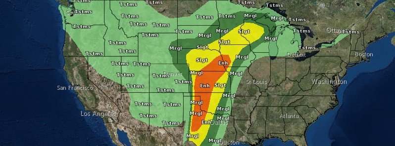
Image credit: NWS
NWS SPC warns that severe thunderstorms are expected Tuesday, May 16, into Tuesday night from portions of the southern Great Plains to the upper Mississippi Valley, with the greatest severe weather risk from southwest Kansas into western Oklahoma and the eastern Texas Panhandle.
Very large and damaging hail and a few tornadoes are expected from late afternoon through evening. Strong tornadoes are possible too.
Damaging winds will be of particular concern from northern Kansas across eastern Nebraska and into western Iowa. Hail and wind are also expected overnight, across much of western and central Texas into Oklahoma. Storms may contain heavy rain and local flooding. Heavy rain is also possible in the northern Plains and Upper Great Lakes.
"The environment will be favorable for supercells (discrete thunderstorms), and thus tornadoes," AccuWeather meteorologists said, adding that a few tornadoes may be capable of long tracks and extreme intensity.
The most widespread impacts from the thunderstorms will be damaging wind gusts, large hail and flash flooding. Disruptions to logistical operations are expected, with downed trees and power lines, road closures and structural damage to businesses and homes all possible.
Damaging severe storms will impact much of the central U.S. into Wednesday: https://t.co/u2FjTy2POG pic.twitter.com/OvL9atr39R
— AccuWeather (@breakingweather) May 16, 2017
The severe weather through midweek will be the start of another active weather pattern across the Central states as more flooding and severe thunderstorms target the region spanning Thursday to Sunday, May 21.
I'm a dedicated researcher, journalist, and editor at The Watchers. With over 20 years of experience in the media industry, I specialize in hard science news, focusing on extreme weather, seismic and volcanic activity, space weather, and astronomy, including near-Earth objects and planetary defense strategies. You can reach me at teo /at/ watchers.news.
Commenting rules and guidelines
We value the thoughts and opinions of our readers and welcome healthy discussions on our website. In order to maintain a respectful and positive community, we ask that all commenters follow these rules.