
New eruption at Bogoslof, Aviation Color Code remains Red
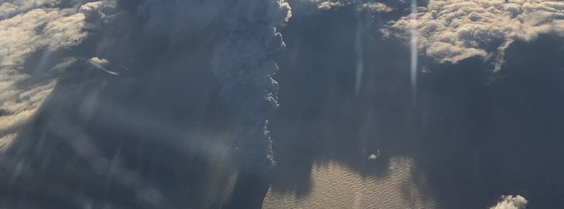
Image credit: Bogoslof erupting on Tuesday, December 20, 2016. Image courtesy of Paul Tuvman.
The Alaska Volcano Observatory (AVO) reports another explosion took place at Bogoslov volcano today. The volcanic ash cloud may have reached as high as 10 km (33 000 feet) above sea level.
The eruption took place at 06:18 UTC on January 4, 2017, but there are no indication of ongoing eruptive activity at this time.
Today's event was short-lived, lasting about 5 minutes, but was detected in seismic, infrasound and lightning data, and formed a volcanic cloud that was visible in satellite images. Winds from the south are carrying the cloud northward over the Bering Sea.
A series of lightning strikes were identified by the World Wide Lightning Location Network
Additional explosive events at Bogoslof may occur without warning. Due to the unpredictability of the situation, the Aviation Color Code remains Red and the Volcano Alert Level Warning.
Meanwhile, other Alaska volcanoes show no signs of significant unrest.
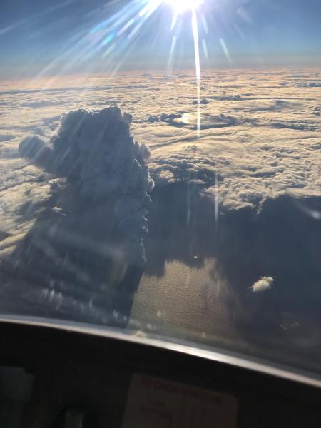
This spectacular photo of Bogoslof's eruption plume was captured on Tuesday, December 20, 2016. Image courtesy of Paul Tuvman.
AVO reminds it has no ground-based volcano monitoring equipment on Bogoslof volcano. It continues to monitor satellite images, data from distant seismic and infrasound instruments, and information from the Worldwide Lightning Location Network for indications of significant activity.
Geological summary
Bogoslof is the emergent summit of a submarine volcano that lies 40 km north of the main Aleutian arc. It rises 1500 m above the Bering Sea floor. Repeated construction and destruction of lava domes at different locations during historical time has greatly modified the appearance of this "Jack-in-the-Box" volcano and has introduced a confusing nomenclature applied during frequent visits of exploring expeditions.
The present triangular-shaped, 0.75 x 2 km island consists of remnants of lava domes emplaced from 1796 to 1992. Castle Rock (Old Bogoslof) is a steep-sided pinnacle that is a remnant of a spine from the 1796 eruption. Fire Island (New Bogoslof), a small island located about 600 m NW of Bogoslof Island, is a remnant of a lava dome that was formed in 1883. (GVP)
The Watchers team and our contributors bring the latest on extreme weather, earthquakes, volcanic eruptions, space weather, and all things science. We're all about making sense of the natural world and keeping you informed on what’s happening. Got a tip or a question? Hit us up using the form at newstips!
Commenting rules and guidelines
We value the thoughts and opinions of our readers and welcome healthy discussions on our website. In order to maintain a respectful and positive community, we ask that all commenters follow these rules.