
Climate models indicate neutral conditions and La Niña equally likely in 2016
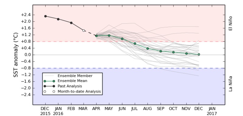
Image credit: TW
The decline of the 2015-16 El Niño continues in the tropical Pacific, the Australian Bureau of Meteorology (BOM) reported today. For southern hemisphere winter and spring, climate models suggest neutral and La Niña conditions are equally likely.
Temperatures below the ocean surface have cooled steadily, with only the top 50 metres more than +1 °C warmer than normal. It is likely this is the coolest this top layer of ocean has been since January 2015. Atmospheric indicators reflect such changes in the ocean. For instance, the Southern Oscillation Index (SOI) has returned to weak El Niño levels. However, some indicators, such as cloudiness near the Date Line, have been slower to respond and still show a clear El Niño signal.
International climate models suggest El Niño will continue to weaken during the southern autumn, returning to neutral levels by mid-2016. For winter and spring, climate models suggest neutral and La Niña are equally likely. However, the accuracy of forecasts made at this time of year is lower than those at other times, and therefore some caution should be exercised.

Although the 2015–16 El Niño is weakening, it will continue to influence climate during the southern hemisphere autumn. In Australia, the breakdown of strong El Niño events has historically brought average to above average rainfall to many locations. However, northern Australia typically sees less rainfall than usual.
Australia's climate is also being influenced by record warm temperatures in the Indian Ocean. The warmth in the Indian Ocean may provide extra moisture for rain systems as they cross Australia during the southern autumn.
Source: BOM
Featured image copyright: BOM

The Watchers team and our contributors bring the latest on extreme weather, earthquakes, volcanic eruptions, space weather, and all things science. We're all about making sense of the natural world and keeping you informed on what’s happening. Got a tip or a question? Hit us up using the form at newstips!
Earlier reporting
Nothing on Watchers was published in the last 24 hours. These are older articles.
- On October 22, 2017, a single flash of lightning stretched 515 miles from eastern Texas to near Kansas City, a distance that takes eight hours to drive, and nobody realized how far it had gone until scientists went back through the satellite data years later Epicenter
- CPC posts a slight risk of heavy rain from the Gulf Coast to the Northeast urban corridor November 25-29, and a moderate risk of West Coast wind and Sierra snow on November 25
- Florida's east coast faces a moderate flash flood risk Wednesday through Friday, with 4 to 8 inches of rain forecast and the St. Johns River near Cocoa already in major flood at 17.13 feet
- Cyclone Akvan to make landfall between Nellore and Visakhapatnam around noon on November 20, IMD forecasts 120-130 km/h winds gusting to 145
