
Very strong and shallow M7.4 earthquake hits Papua New Guinea
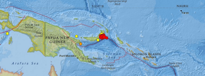
Image credit: USGS
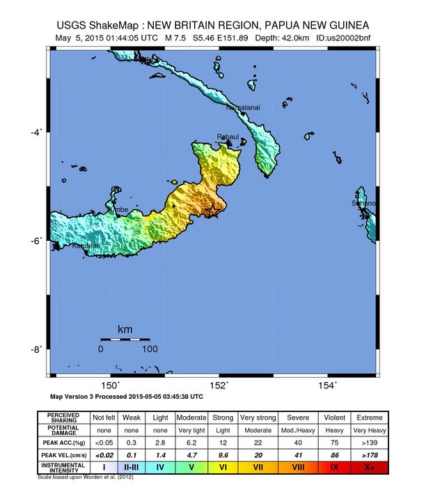
A very strong earthquake measured by Geoscience Australia as M7.4 at a depth of 35 km (21.7 miles) hit New Britain, Papua New Guinea at 01:44 UTC on May 5, 2015. USGS is reporting this quake as M7.5 at a depth of 42 km (26.1 miles).
According to Geoscience Australia, this is third M7.1+ earthquake to hit this region since April 30, 2015 (M7.1 on April 30; M7.1 on May 1). USGS recorded those two quakes as M6.7 and M6.8.
By 05:10 UTC, USGS recorded 5 strong aftershocks.
Epicenter was located about 130 km (81 miles) SSW of Kokopo, 193 km (120 miles) E of Kimbe, 341 km (212 miles) SSE of Kavieng, 412 km (256 miles) WNW of Arawa, and 680 km (423 miles) NE of Port Moresby, Papua New Guinea.
There are about 39 736 people living within 100 km radius.
Based on the preliminary earthquake parameters, hazardous tsunami waves are possible for the coasts located within 300 km of the earthquake epicenter, PTWC said in their 01:50 UTC Tsunami Threat Message. Tsunami waves reaching 0.3 to 1 meters above the tide level are possible for some coasts of Papua New Guinea.
In their final Tsunami Threat Message issued 03:26 UTC, PTWC said the Port Moresby observatory has reported some tsunami oscillations in Rabaul harbor. Based on all data available to this center, the tsunami threat from this earthquake has now mostly passed. Any remaining threat should be evaluated by local authorities in impacted areas.
There were no immediate reports of waves being seen and no reports of damage, said Chris McKee, assistant director Geophysical Observatory in the capital, Port Moresby. “The earthquake is offshore and the nearby land areas are fairly sparsely populated,” McKee said.
The National Disaster Center also had not received any reports of damage, said acting director Martin Mose.
USGS issued yellow alert for shaking-related fatalities and economic losses. Some casualties and damage are possible and the impact should be relatively localized. Past yellow alerts have required a local or regional level response. Estimated economic losses are less than 1% of GDP of Papua New Guinea.
Overall, the population in this region resides in structures that are vulnerable to earthquake shaking, though some resistant structures exist. The predominant vulnerable building types are unreinforced brick masonry and informal (metal, timber, GI etc.) construction.
Recent earthquakes in this area have caused secondary hazards such as tsunamis and landslides that might have contributed to losses.
The office of Geoscience Observatory in Port Moresby said earthquakes felt today and yesterday are part of a series of aftershocks of last week’s magnitude 6.8 quakes in the Pomio region.
It said all of these earthquakes were tectonic, caused by interaction of the Solomon and South Bismarck tectonic plates and have been confined to the Pomio region.
“The aftershock sequence was normal for tectonic earthquakes and may continue for several days, but the strength of the earthquakes should decrease with time. Standard precautionary measures appropriate for earthquake apply and that the earthquake activity was separate from the volcanoes at Rabaul."
Today's earthquake occurred as the result of thrust faulting on or near the plate boundary interface between the subducting Australia and overriding Pacific plates, USGS said.
"At the location of the earthquake, the Australia plate moves towards the east-northeast at a velocity of 105 mm/yr with respect to the Pacific plate, and begins its subduction into the mantle beneath New Britain at the New Britain Trench, south-southeast of the earthquake. The moment tensor and depth of the event are consistent with thrust-type motion on the interface between these two plates. Note that at the location of the earthquake, some researchers divide the edges of the Australia and Pacific plates into several microplates that take up the overall convergence between Australia and the Pacific, including the Solomon Sea and South Bismark microplates local to this event. The Solomon Sea plate moves slightly faster and more northeasterly with respect to the Pacific plate than does Australia due to sea-floor spreading in the Woodlark Basin several hundred kilometers to the southeast of the May 5 earthquake, facilitating the classic subduction evident beneath New Britain.
While commonly plotted as points on maps, earthquakes of this size are more appropriately described as slip over a larger fault area. Events of the magnitude of the May 5, 2015 earthquake are typically about 70×40 km in size (length x width).
The plate boundary between the Australia and Pacific plates in the Papua New Guinea region is very active seismically; 36 M 7+ events have occurred within 250 km of the May 5, 2015 earthquake over the past century. Few are known to have caused shaking-related fatalities because of the remoteness of the region, though a M 8.0 earthquake in November 2000 – one of three similarly sized events over a 2-day period – did cause several deaths. The largest nearby earthquake was an M 8.1 event, 150 km to the east-northeast of the May 5, 2015 earthquake, one of two M8+ earthquakes 140 km apart in July 1971. The May, 2015 earthquake is just 10 km to the east-northeast of the November 17, 2000 M 7.8 earthquake, also thrust-faulting event on the plate boundary interface.
The May 5 earthquake has also been preceded by a series of moderate-to-large earthquakes on this portion of the plate boundary over the past several weeks, beginning with a M 7.5 event on March 29, 2015, 110 km to the northeast of the May 5, 2015 earthquake. Between these two large events, 25 other earthquakes of M 5+ have occurred in the same area; including M 6.7 and M 6.8 events just to the northwest of the May 5 earthquake, on April 30 and May 1, respectively."
USGS recorded 19 earthquakes in this region since April 30, 2015:
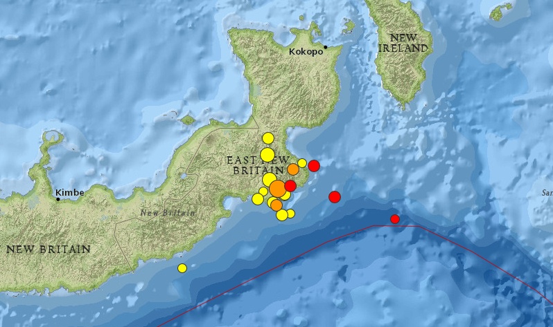
Image credit: USGS
- 5.22015-05-05 03:55:51 UTC51.8 km
- 5.22015-05-05 02:40:23 UTC33.9 km
- 4.42015-05-05 02:33:39 UTC35.0 km
- 5.62015-05-05 01:58:20 UTC57.5 km
- 5.92015-05-05 01:54:05 UTC64.5 km
- 7.52015-05-05 01:44:05 UTC42.0 km
- 5.12015-05-04 08:09:14 UTC60.8 km
- 4.62015-05-04 01:04:48 UTC63.3 km
- 5.22015-05-03 23:40:56 UTC35.1 km
- 5.12015-05-03 22:50:47 UTC46.1 km
- 5.52015-05-03 22:35:11 UTC67.9 km
- 5.62015-05-03 22:32:42 UTC35.0 km
- 5.22015-05-03 20:21:56 UTC76.0 km
- 4.82015-05-03 19:28:54 UTC61.0 km
- 4.32015-05-03 07:24:28 UTC56.6 km
- 5.02015-05-02 10:53:06 UTC103.4 km
- 4.92015-05-01 19:55:56 UTC44.5 km
- 6.82015-05-01 08:06:04 UTC57.0 km
- 6.72015-04-30 10:45:05 UTC48.9 km
Seismotectonics of the New Guinea Region and Vicinity
The Australia-Pacific plate boundary is over 4000 km long on the northern margin, from the Sunda (Java) trench in the west to the Solomon Islands in the east. The eastern section is over 2300 km long, extending west from northeast of the Australian continent and the Coral Sea until it intersects the east coast of Papua New Guinea. The boundary is dominated by the general northward subduction of the Australia plate.
Along the South Solomon trench, the Australia plate converges with the Pacific plate at a rate of approximately 95 mm/yr towards the east-northeast. Seismicity along the trench is dominantly related to subduction tectonics and large earthquakes are common: there have been 13 M7.5+ earthquakes recorded since 1900. On April 1, 2007, a M8.1 interplate megathrust earthquake occurred at the western end of the trench, generating a tsunami and killing at least 40 people. This was the third M8.1 megathrust event associated with this subduction zone in the past century; the other two occurred in 1939 and 1977.
Further east at the New Britain trench, the relative motions of several microplates surrounding the Australia-Pacific boundary, including north-south oriented seafloor spreading in the Woodlark Basin south of the Solomon Islands, maintain the general northward subduction of Australia-affiliated lithosphere beneath Pacific-affiliated lithosphere. Most of the large and great earthquakes east of New Guinea are related to this subduction; such earthquakes are particularly concentrated at the cusp of the trench south of New Ireland. 33 M7.5+ earthquakes have been recorded since 1900, including three shallow thrust fault M8.1 events in 1906, 1919, and 2007.
The western end of the Australia-Pacific plate boundary is perhaps the most complex portion of this boundary, extending 2000 km from Indonesia and the Banda Sea to eastern New Guinea. The boundary is dominantly convergent along an arc-continent collision segment spanning the width of New Guinea, but the regions near the edges of the impinging Australia continental margin also include relatively short segments of extensional, strike-slip and convergent deformation. The dominant convergence is accommodated by shortening and uplift across a 250-350 km-wide band of northern New Guinea, as well as by slow southward-verging subduction of the Pacific plate north of New Guinea at the New Guinea trench. Here, the Australia-Pacific plate relative velocity is approximately 110 mm/yr towards the northeast, leading to the 2-8 mm/yr uplift of the New Guinea Highlands.
Whereas the northern band of deformation is relatively diffuse east of the Indonesia-Papua New Guinea border, in western New Guinea there are at least two small (<100,000 km²) blocks of relatively undeformed lithosphere. The westernmost of these is the Birds Head Peninsula microplate in Indonesia's West Papua province, bounded on the south by the Seram trench. The Seram trench was originally interpreted as an extreme bend in the Sunda subduction zone, but is now thought to represent a southward-verging subduction zone between Birds Head and the Banda Sea.
There have been 22 M7.5+ earthquakes recorded in the New Guinea region since 1900. The dominant earthquake mechanisms are thrust and strike slip, associated with the arc-continent collision and the relative motions between numerous local microplates. The largest earthquake in the region was a M8.2 shallow thrust fault event in the northern Papua province of Indonesia that killed 166 people in 1996.
The western portion of the northern Australia plate boundary extends approximately 4800 km from New Guinea to Sumatra and primarily separates Australia from the Eurasia plate, including the Sunda block. This portion is dominantly convergent and includes subduction at the Sunda (Java) trench, and a young arc-continent collision.
In the east, this boundary extends from the Kai Islands to Sumba along the Timor trough, offset from the Sunda trench by 250 km south of Sumba. Contrary to earlier tectonic models in which this trough was interpreted as a subduction feature continuous with the Sunda subduction zone, it is now thought to represent a subsiding deformational feature related to the collision of the Australia plate continental margin and the volcanic arc of the Eurasia plate, initiating in the last 5-8 Myr. Before collision began, the Sunda subduction zone extended eastward to at least the Kai Islands, evidenced by the presence of a northward-dipping zone of seismicity beneath Timor Leste. A more detailed examination of the seismic zone along it's eastern segment reveals a gap in intermediate depth seismicity under Timor and seismic mechanisms that indicate an eastward propagating tear in the descending slab as the negatively buoyant oceanic lithosphere detaches from positively buoyant continental lithosphere. On the surface, GPS measurements indicate that the region around Timor is currently no longer connected to the Eurasia plate, but instead is moving at nearly the same velocity as the Australia plate, another consequence of collision.
Large earthquakes in eastern Indonesia occur frequently but interplate megathrust events related to subduction are rare; this is likely due to the disconnection of the descending oceanic slab from the continental margin. There have been 9 M7.5+ earthquakes recorded from the Kai Islands to Sumba since 1900. The largest was the great Banda Sea earthquake of 1938 (M8.5) an intermediate depth thrust faulting event that did not cause significant loss of life. (USGS) More information on regional seismicity and tectonics
I'm a dedicated researcher, journalist, and editor at The Watchers. With over 20 years of experience in the media industry, I specialize in hard science news, focusing on extreme weather, seismic and volcanic activity, space weather, and astronomy, including near-Earth objects and planetary defense strategies. You can reach me at teo /at/ watchers.news.
Commenting rules and guidelines
We value the thoughts and opinions of our readers and welcome healthy discussions on our website. In order to maintain a respectful and positive community, we ask that all commenters follow these rules.