
Rapidly intensifying winter storm turns deadly, Japan
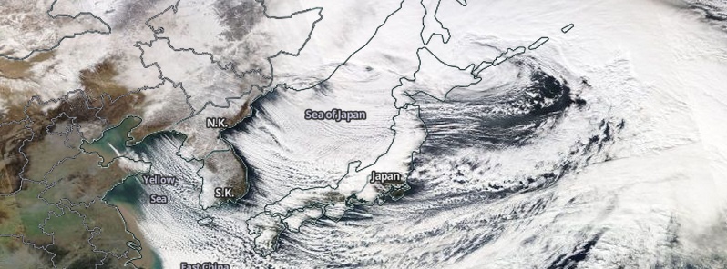
Featured image: Severe winter storm over Japan on December 17, 2014. Credit: NASA Aqua/MODIS
A rapidly intensifying low-pressure mass, which started in eastern China earlier this week, is causing heavy snow, strong winds and high waves across the northern Japan today. By Wednesday morning, extreme weather events already claimed lives of at least 3 people.
Japan Meteorological Agency (JMA) said storms will continue today and through Thursday, especially in Hokkaido and other parts of northern Japan. They warned of blizzards, tidal waves and avalanches and called for people to refrain from going outside.
Typhoon strength winds of around 144 km/h (89 mph) were recorded in Hokkaido on Wednesday. Winds of up to 180 km/h (111 mph) are still possible throughout the region, especially along the western sea boards.
While some areas already experienced over 200 cm (6.5 feet) of snow, snow totals topping 10 – 20 cm (3.9 – 7.8 inches) per hour continue to occur.
Travel was severely disrupted in both Hokkaido and Tohoku. Hokkaido Railway Co. said 349 trains, including commuter services and limited express trains, ground to a halt in areas such as Sapporo, Hakodate, Kushiro and Wakkanai. All Nippon Airways Co. and Japan Airlines Co. canceled more than 280 domestic flights and some of their international services, affecting about 17 000 passengers, The Japan Times reported.
According to a statement released by American Airlines, a U.S. passenger jet was forced to make an emergency landing near Tokyo after encountering severe turbulence while trying to fly through the storm. Five people on the flight were hospitalized with non-life-threatening injuries, and as many as nine other were treated at the scene.
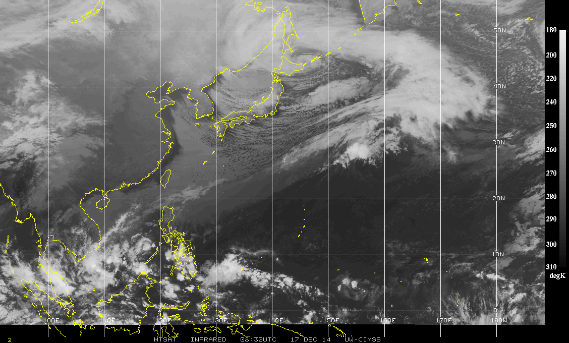
MTSAT Infrared image on December 17, 2014. Image credit: UW-CIMSS
As the storm moved east over Japan the mountains of the country split it in to two giving us the defined double barrow or split low we are seeing on satellite imagery Wednesday morning. This, combined with a strong cold upper level low and the warm waters of the Kuroshio current, is allowing the storm to undergo some rapid cyclogenesis. Also known by media recently as “bombogenesis”…
The storm already brought heavy rain and damaging winds to coastal Shikoku through Kanto Tuesday night but now the big impact from it will be the blizzard taking place in Hokkaido and much of the Sea of Japan coastline due to sea effect snow combined with a tight pressure gradient around the 950 hpa low. (WestPacWx)
I'm a dedicated researcher, journalist, and editor at The Watchers. With over 20 years of experience in the media industry, I specialize in hard science news, focusing on extreme weather, seismic and volcanic activity, space weather, and astronomy, including near-Earth objects and planetary defense strategies. You can reach me at teo /at/ watchers.news.
Commenting rules and guidelines
We value the thoughts and opinions of our readers and welcome healthy discussions on our website. In order to maintain a respectful and positive community, we ask that all commenters follow these rules.