
Surprising, strong eruption of San Miguel volcano, El Salvador
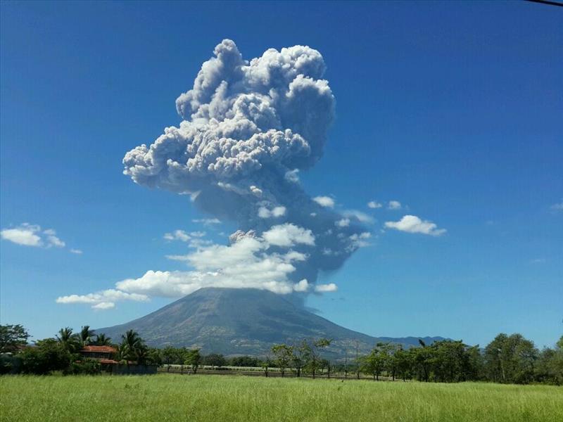
Featured image: San Miguel eruption - December 29, 2013. Credit: Francisco Romero
After 11 sleepy years, San Miguel volcano (Chaparrastique) in El Salvador experienced a strong eruption on December 29, 2013 at 16:50 UTC (10:50 am local time). Eruption column was estimated rising up to 9 km (29 500 feet) and civil alert status for the area around the volcano was raised to yellow.
According to local press, ashfall was expected in the town of Chinameca and Civil Protection has begun evacuations of families residing in a radius of 3 km around the volcano.
The latest entry to GVP's weekly volcanic report was in the week of March 23 – 29, 2011:
"Servicio Nacional de Estudios Territoriales (SNET) reported that during a survey of the San Miguel crater on 9 and 16 March observers noted pulses of gas rising 200 m from the crater. On 12 March the number and amplitude of earthquakes increased. RSAM values rose the next day to 121 units per day on average, up from normal values around 50 units per day. RSAM values continued to fluctuate during the next few days and reached as high as 319 units on 19 March, 414 units on 20 March, and 234 on 21 March. On 18 and 20 March, local residents felt vibrations and heard minor rumbling. Observations on 25 March indicated that gas plumes rose 100 m from the crater. On 28 March SNET noted that seismicity had gradually decreased during the previous few days, and was as low as 80 RSAM units on 27 March. Access to areas within a 2-km-radius remained restricted."
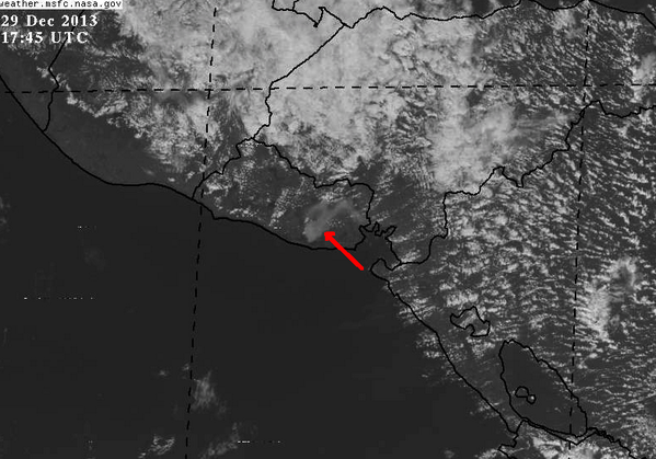
Image credit: NASA / MSFC
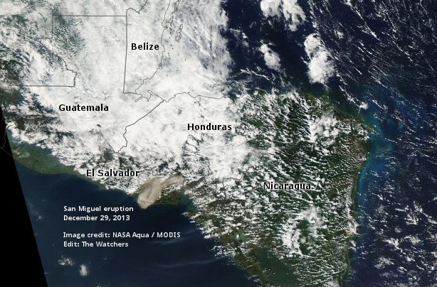
San Miguel eruption, El Salvador on December 29, 2013. Image credit: NASA Aqua / MODIS. Edit: The Watchers
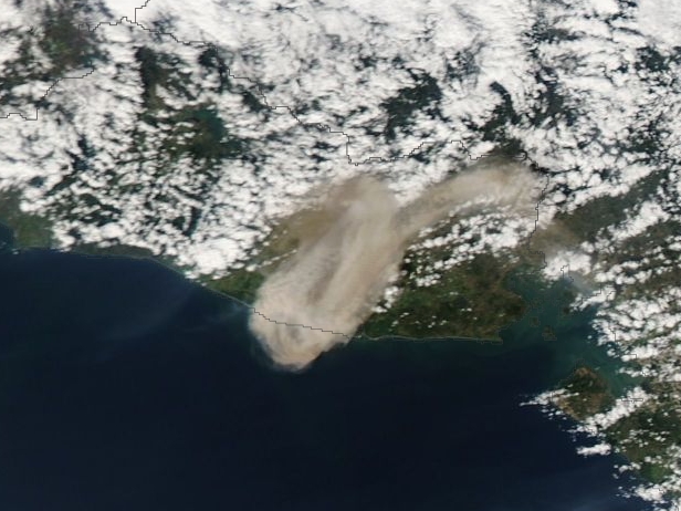
San Miguel eruption, El Salvador on December 29, 2013. Image credit: NASA Aqua / MODIS
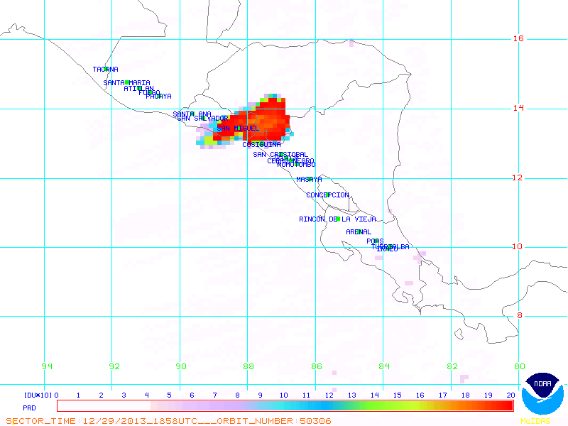
San Miguel eruption OMI / SO2, El Salvador on December 29, 2013. Image credit: NOAA / NESDIS
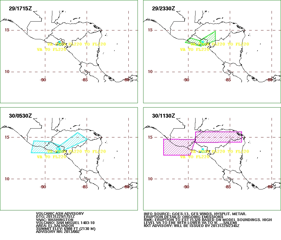
San Miguel, El Salvador – Volcanic ash advisory. Image credit: SSD/NOAA – Washington VAAC
The symmetrical cone of San Miguel volcano, one of the most active in El Salvador, rises from near sea level to form one of the country's most prominent landmarks. The unvegetated summit of the 2130-m-high volcano rises above slopes draped with coffee plantations. A broad, deep crater complex that has been frequently modified by historical eruptions (recorded since the early 16th century) caps the truncated summit of the towering volcano, which is also known locally as Chaparrastique.
Radial fissures on the flanks of the basaltic-andesitic volcano have fed a series of historical lava flows, including several erupted during the 17th-19th centuries that reached beyond the base of the volcano on the north, NE, and SE sides. The SE-flank lava flows are the largest and form broad, sparsely vegetated lava fields crossed by highways and a railroad skirting the base of the volcano. The location of flank vents has migrated higher on the edifice during historical time, and the most recent activity has consisted of minor ash eruptions from the summit crater (GVP).
- Find more images of today's eruption here.
I'm a dedicated researcher, journalist, and editor at The Watchers. With over 20 years of experience in the media industry, I specialize in hard science news, focusing on extreme weather, seismic and volcanic activity, space weather, and astronomy, including near-Earth objects and planetary defense strategies. You can reach me at teo /at/ watchers.news.
it's not that surprising when you consider…..
http://www.youtube.com/watch?v=DWrbQvg-ssE&feature=youtu.be
The earth has already become surrounded by a blanket of ionized plasma over 80,000 miles thick, and expanding at the rate of 15,000 miles per year — around 40 miles per day. This all began in 2008, when NASA’s THEMIS mission discovered earth-sized breaches in the magnetosphere, allowing solar and cosmic ray plasma to pour through and build up in near-earth space — called the plasmasphere. ESA’s 2012 CLUSTER mission verified that the breaches were still open. In 2014, NASA is launching another mission to study this phenomenon further.
A favorite theme of science fiction is "the portal"–an extraordinary opening in space or time that connects travelers to distant realms. A good portal is a shortcut, a guide, a door into the unknown. If only they actually existed…. It turns out that they do, sort of, and a NASA-funded researcher at the University of Iowa has figured out how to find them.
"We call them X-points or electron diffusion regions," explains plasma physicist Jack Scudder of the University of Iowa. "They're places where the magnetic field of Earth connects to the magnetic field of the Sun, creating an uninterrupted path leading from our own planet to the sun's atmosphere 93 million miles away."
Observations by NASA's THEMIS spacecraft and Europe's Cluster probes suggest that these magnetic portals open and close dozens of times each day. They're typically located a few tens of thousands of kilometers from Earth where the geomagnetic field meets the onrushing solar wind. Most portals are small and short-lived; others are yawning, vast, and sustained. Tons of energetic particles can flow through the openings, heating Earth's upper atmosphere, sparking geomagnetic storms, and igniting bright polar auroras.
http://www.theregister.co.uk/2013/04/08/chinese_entanglement_transfer_experiment/
Milankovitch theory describes the collective effects of changes in the Earth's movements upon its climate, named after Serbian geophysicist and astronomer Milutin Milanković, who worked on it during First World War internment. Milanković mathematically theorized that variations in eccentricity, axial tilt, and precession of the Earth's orbit determined climatic patterns on Earth through orbital forcing.
http://developyourenergy.net/2010/09/20/understanding-chi-cycles/
http://www.invisibletemple.com/manuscript7.1.html
http://www.youtube.com/watch?v=wQmut0XtD3s
http://www.euclideanrelativity.com/pdf/fractaluniverse-rfjvl.pdf
Always interesting to read your comments Stephen! 🙂