
Very dangerous Tropical Cyclone “Eloise” to make landfall near Beira, Mozambique
Featured image: Tropical Storm "Eloise" at 13:10 UTC on January 22, 2021. Credit: EUMETSAT/Meteosat-8, RAMMB/CIRA, TW
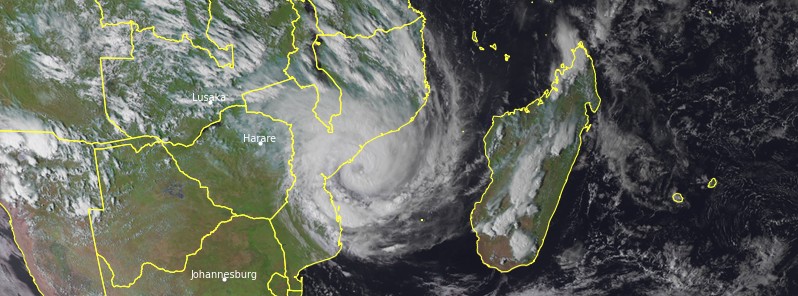
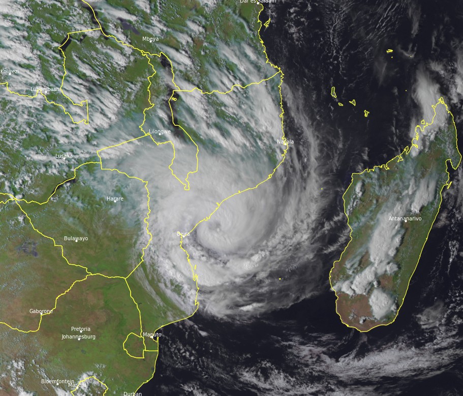
Tropical Cyclone "Eloise" is moving WSW over the Mozambique Channel, towards the central coast of Mozambique. Environmental conditions are conducive for significant or even rapid strengthening before landfall on the evening of January 22 (LT) or the morning of January 23 over the city of Beira, ravaged by Tropical Cyclone "Idai" in 2019.
- Eloise represents a significant threat to the area near Beira, between Quelimane in the north and the Save River in the south.
- In the next 24 hours, 150 to 250 mm (5.9 – 10 inches) of rainfall is expected between Quelimane and Inhambane, and more than 300 mm (11.8 inches) in the region of Beira.
- Wind gusts will exceed 100 km/h (62 mph) over the entire coastline and between 150 and 200 km/h (95 – 125 mph) close to the impact point.
- A storm surge of about 1 to 1.5 m (3.3 to 5 feet) on average is expected north of Beira and between 1.5 and 2 m (5 – 6.5 feet) south of Beira.
- This storm surge could exceed 3 m (10 feet) according to the most unfavorable scenario (landfall on or north of Beira), near the Pungwe River.
- Inhabitants of Mozambique are invited to follow the instructions of the local authorities.
At 12:00 UTC on January 22, the center of Tropical Cyclone "Eloise" was located about 240 km (150 miles) NNE of Beira, Mozambique. It had maximum 10-minute sustained winds of 120 km/h (75 mph), 1-minute sustained winds of 140 km/h (85 mph), and gusts up to 150 km/h (90 mph). The minimum central barometric pressure was 978 hPa.
The storm was moving WSW at 20 km/h (13 mph).
Eloise is expected to continue on a WSW track across the Mozambique Channel, moving along the northwestern edge of the subtropical ridge located southeast of Madagascar.
Landfall is expected in Mozambique tonight or tomorrow morning (LT), January 23, RSMC La Reunion said in their bulletin released 12:00 UTC today. The timing and location of the landfall could change significantly given the configuration of the coastline, the center added.
From Monday, January 25, the remnants of Eloise are expected to drift westward, driven by a new ridge arriving from the west.
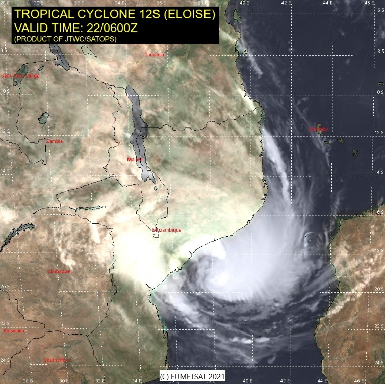
Image credit: EUMETSAT, JTWC/SATOPS
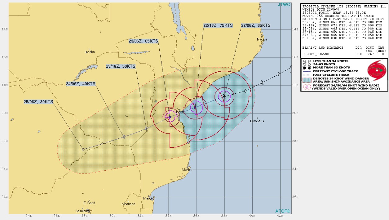
Image credit: JTWC
In terms of intensity, environmental conditions are conducive for a significant or even rapid intensification (warm waters, humid environment, no shear and excellent upper divergence).
Nevertheless, the proximity to the land may limit the potential for intensification.
The stage of an intense tropical cyclone is not excluded but becomes unlikely, the center said.
In terms of impacts, Eloise represents a significant threat to the area near Beira, between Quelimane in the north and the Save River in the south.
In the next 24 hours, 150 to 250 mm (5.9 – 10 inches) of rainfall is expected between Quelimane and Inhambane, and more than 300 mm (11.8 inches) in the region of Beira.
Tonight and tomorrow, this risk should also concern the inland areas.
Wind gusts will exceed 100 km/h (62 mph) over the entire coastline and between 150 and 200 km/h (95 – 125 mph) close to the impact point.
A storm surge of about 1 to 1.5 m (3.3 to 5 feet) on average is expected north of Beira and between 1.5 and 2 m (5 – 6.5 feet) south of Beira.
This storm surge could exceed 3 m (10 feet) according to the most unfavorable scenario (landfall on or north of Beira), near the Pungwe River.
Although of low coefficient, the high tide at 00:00 UTC, January 23 could be an aggravating factor.
Inhabitants of Mozambique are invited to follow the instructions of the local authorities.
Tropical Storm "Eloise" at 13:10 UTC on January 22, 2021. Credit: EUMETSAT/Meteosat-8, RAMMB/CIRA, TW
In northern Madagascar, the passage of Eloise brought heavy rainfall and floods, leaving at least 1 person dead and about 190 damaged or destroyed homes.
In Mozambique, pre-emptive evacuations were undertaken in Sofala Province, as reported by UN OCHA.
In Zimbabwe, some of the major rivers are expected to peak throughout the next week as a result of the fresh rainfall brought by Eloise.
Floods are also expected across the border between Mozambique and Zimbabwe.
Locally heavy rainfall is forecast over north-western Madagascar.
I'm a dedicated researcher, journalist, and editor at The Watchers. With over 20 years of experience in the media industry, I specialize in hard science news, focusing on extreme weather, seismic and volcanic activity, space weather, and astronomy, including near-Earth objects and planetary defense strategies. You can reach me at teo /at/ watchers.news.
Commenting rules and guidelines
We value the thoughts and opinions of our readers and welcome healthy discussions on our website. In order to maintain a respectful and positive community, we ask that all commenters follow these rules.