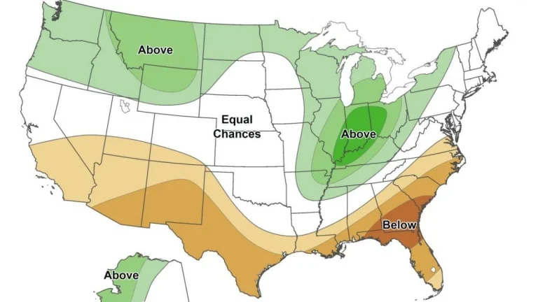
• Major atmospheric river moves into Washington State, triggering widespread and potentially historic riverine flooding

    A major atmospheric river is producing very heavy precipitation across western Washington today into early December 11, 2025, triggering widespread and potentially historic riverine flooding, according to the Center for Western Weather and Water Extremes (CW3E). Forecasts indicate 130–200 mm (5–8 inches) of rain over the central and northern Washington Cascades and 75–130 mm (3–5 inches) over the Olympic Peninsula through 04:00 PST (12:00 UTC) on December 12. CW3E modeling shows 15 river gauges expected to exceed major flood stage and four to surpass record levels within 48 hours.

  • Multi-model forecasts indicate increased atmospheric river activity and transition from West Coast Ridge to Pacific Ridge in late December

    Subseasonal forecasts by CW3E show strong multi-model agreement on above-normal atmospheric river activity across the U.S. West Coast during mid- to late December, with the strongest signals over Northern California. Forecast regime tools indicate a transition from a West Coast Ridge to a Pacific Ridge during this period, altering temperature and precipitation patterns across the region.

  • Blizzard warnings in effect for parts of West Virginia and western Maryland

    Blizzard warning have been issued with snowfall totals of up to 30 cm (12 inches) being forecast across the high western slopes along with gusts of 80 km/h (50 mph) across multiple mountain counties. The warnings are in effect for parts of West Virginia, western Maryland, and western Virginia from 10:00 EST Wednesday, December 10, 2025 to 10:00 EST Thursday, December 11.

  • Major atmospheric river brings heavy rain and flooding to Pacific Northwest

    Two successive atmospheric river pulses are affecting the Pacific Northwest this week, delivering multi-day heavy rainfall and flooding risk across western Washington and northwestern Oregon. The first made landfall early December 9, and a stronger second pulse is forecast to arrive late December 9–early December 10, maintaining high integrated vapor transport and major flood potential through December 11.