Tokyo experiences hottest March day on record
Record-breaking temperatures were measured in Japan on Wednesday, March 26, 2025, with 143 stations either tying or breaking the record for the hottest March day on record.


Record-breaking temperatures were measured in Japan on Wednesday, March 26, 2025, with 143 stations either tying or breaking the record for the hottest March day on record.

Sukayu Onsen, located in the mountains of Japan’s Aomori Prefecture, recorded its heaviest snowfall in 12 years on Thursday, February 12, 2025, with snow depths exceeding 5 m (16.4 feet).

Japan is experiencing its strongest cold wave of the season, with multiple prefectures recording over 1 m (3.3 feet) of snowfall in just 72 hours, setting multiple records across the country.

Heavy sea-effect snow has been affecting parts of Japan since Thursday, January 9, 2025, with more than 1 m (3 feet) of snow already registered in some regions and snowfall expected to persist through Saturday. Certain areas have already received twice the usual snowfall.

Former Super Typhoon “Kong-rey” brought record-breaking rainfall to coastal China after causing significant destruction in Taiwan, where it left 3 people dead and over 500 injured. What’s left of this storm is now moving toward Japan, with western regions already experiencing its effects, expected to last into November 2. Eastern Japan and the Tohoku region are likely to be impacted from November 2 to 3, with risks of landslides, flooding in low-lying areas, and rising river levels.

Eleven people have been confirmed dead following unprecedented rainfall that hit Japan’s Ishikawa Prefecture on Friday and Saturday, September 21 and 22, 2024, resulting in severe flooding and widespread damage across the region.

Heavy torrential rains struck the Ishikawa Prefecture in Japan on Friday and Saturday, September 20 and 21, 2024, leading to severe flooding in the region, and prompting the highest level of flood alert. Wajima City recorded 318.5 mm (12.5 inches) of rainfall between Friday and Saturday, while Suzu recorded 226 mm (8.9 inches) of rain within the same period. One person was killed and more than 10 remain missing, as of 12:00 UTC today.

Tropical Storm “Bebinca” — the 13th named storm of the 2024 Pacific typhoon season, formed on September 13, 2024, as it passed near Guam. The system is forecast to continue moving toward Japan, cross the Ryukyu Islands today, and make landfall in the coastal area around Shanghai, China on Monday morning (LT), September 16.
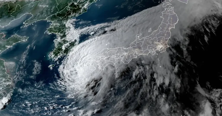
Typhoon “Shanshan” made landfall near Satsumasendai City in Kyushu, Japan on Thursday, August 29, 2024. The powerful storm, with wind gusts reaching 198 km/h (123 mph), triggered severe flooding and landslides, prompting evacuation orders affecting millions in southwestern Japan.
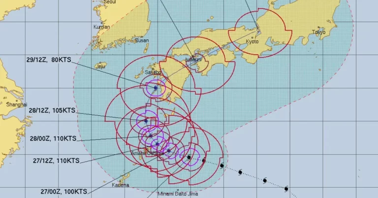
Typhoon “Shanshan” has slowed down as it neared Japan on August 26, 2024. The system is projected to approach western Japan and the Amami region from Tuesday through Wednesday, August 27 and 28, bringing strong winds and heavy rain, particularly along the Pacific coast. JTWC forecast places the landfall point south of Sasebo at approximately 15:00 UTC on August 29 with maximum sustained winds of around 150 km/h (92 mph).