
How the 2004 Indian Ocean tsunami reshaped global disaster preparedness
When a M9.1–M9.3 megathrust earthquake struck northern Sumatra at 00:58 UTC (07:58 local time) on December 26, 2004, it unleashed a basin-wide tsunami that killed more than 227 000 people and transformed global approaches to tsunami warning and coastal preparedness.
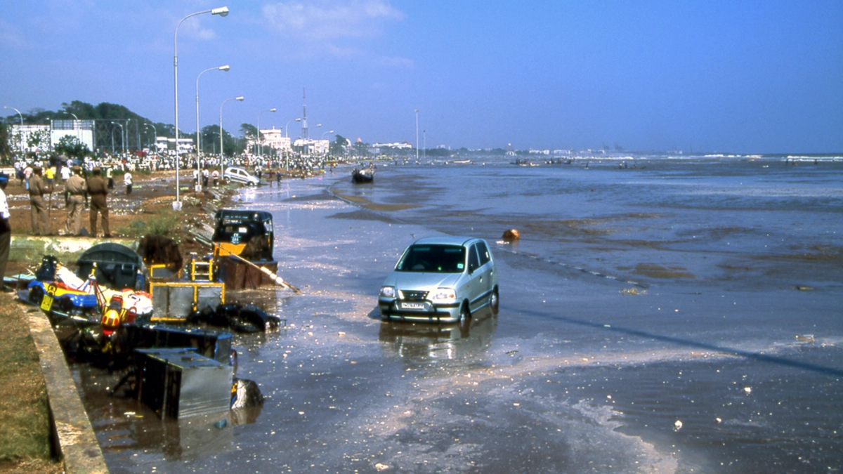
Marina Beach in Chennai after the first tsunami wave on December 26, 2004. Credit: Henryk Kotowski
At 07:58 LT on December 26, a megathrust earthquake with a magnitude of M9.1–M9.3 ruptured the seafloor off the west coast of northern Sumatra, Indonesia. The earthquake occurred along the Sunda subduction zone, where the Indo-Australian Plate is forced beneath the Burma and Sunda plates.
What made this earthquake exceptional was not only its magnitude, but the sheer length of the rupture. Seismological analyses show that the fault broke over approximately 1 300 km (810 miles), making it one of the longest earthquake ruptures ever recorded instrumentally.
Slip along the fault exceeded 20 m (66 feet) in several segments, vertically displacing enormous volumes of seawater. This sudden uplift and subsidence of the seabed is what transformed a powerful earthquake into a basin-scale tsunami generator.
The rupture unfolded over 8–10 minutes, far longer than most large earthquakes. This prolonged release of energy allowed the tsunami to be continuously reinforced as it propagated northward along the plate boundary.
The event forced scientists to reconsider long-standing assumptions that megathrust segments rupture independently. The 2004 earthquake demonstrated that multiple segments can fail in a cascading sequence, a finding that reshaped seismic hazard models worldwide.
A tsunami that crossed an entire ocean basin
The vertical displacement of the seafloor generated tsunami waves that radiated across the Indian Ocean in all directions. In deep water, these waves traveled at speeds approaching 700–800 km/h (435–500 mph), fast enough to cross the ocean basin in a matter of hours.
In the open ocean, the tsunami remained barely noticeable, with wave heights of only tens of centimeters. The danger emerged as the waves entered shallower coastal waters, where they slowed, compressed, and grew dramatically in height.
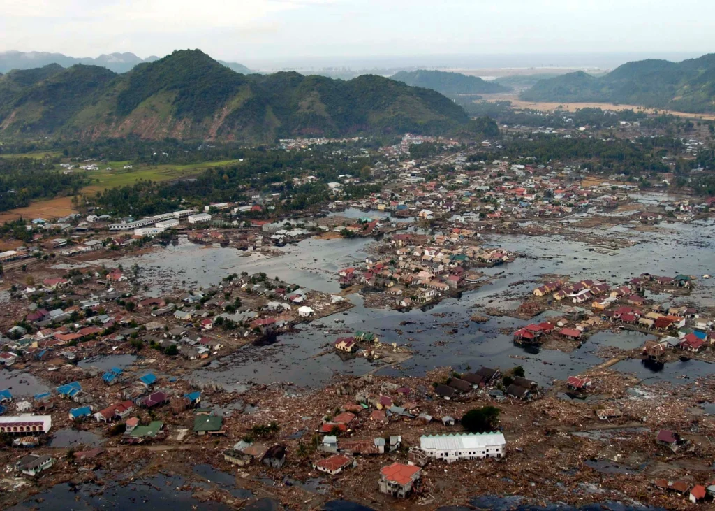
Local bathymetry and coastal geometry played a decisive role in shaping the disaster. Narrow bays, continental shelves, and underwater ridges focused tsunami energy onto specific coastlines, producing devastating run-up heights.
In parts of Aceh Province, tsunami run-up exceeded 30 m (98 feet), overwhelming entire coastal communities. In contrast, some nearby locations experienced significantly lower wave heights, illustrating the extreme spatial variability of tsunami impacts.
Satellite altimetry missions and coastal tide gauges captured the tsunami as it traversed the ocean, providing scientists with the first truly global observational dataset of a major tsunami and revolutionizing tsunami modeling and forecasting.
When minutes and hours decided survival
The tsunami’s arrival times varied dramatically across the Indian Ocean, exposing the fundamental difference between near-field and distant tsunami risk. In northern Sumatra and the Andaman and Nicobar Islands, the first waves arrived within 15–30 minutes, leaving no opportunity for official warnings.
In Thailand, including Phuket, tsunami waves arrived roughly 1.5–2 hours after the earthquake. Coastal areas of Sri Lanka were struck after about 2 hours, while parts of India experienced waves between 2–3 hours later.
The Maldives recorded significant flooding approximately 3–4 hours after the rupture, despite its low elevation and distance from the epicenter. Entire islands were temporarily submerged, demonstrating the vulnerability of low-lying atolls.
The tsunami continued westward, reaching East Africa between 7–11 hours after the earthquake. Somalia, Kenya, and Tanzania experienced destructive waves long after the earthquake had faded from global headlines.
This basin-wide timing sequence later became central to redesigning tsunami warning systems, showing clearly that distant coastlines often have hours to act, while communities near the source do not.
Why distance did not mean safety
One of the most important lessons from the 2004 Sumatra – Andaman Islands Earthquake was the distinction between near-field and distant tsunamis. Near-field tsunamis strike coastlines close to the earthquake source, often before any official alert can be issued.
In these settings, survival depends almost entirely on immediate self-evacuation triggered by natural warning signs such as intense ground shaking or sudden sea withdrawal. Technology cannot outrun physics when wave arrival follows within minutes.
Distant tsunamis behave differently. When waves must cross thousands of kilometers, seismic detection, ocean sensors, and coordinated alerts can provide crucial lead time for evacuation.
The tragedy of 2004 revealed that many Indian Ocean communities lacked both technological warnings and cultural memory of tsunamis. Even after violent shaking, many people did not associate the earthquake with an impending ocean threat.
This gap in risk literacy proved as deadly as the absence of warning infrastructure, a realization that reshaped disaster education strategies worldwide.
Africa and the far-field disaster rarely remembered
The impact of the tsunami on East Africa underscored its truly global reach. Coastal communities in Somalia, located thousands of kilometers from the epicenter, were struck without any perception of danger.
Fishing villages were destroyed, ports damaged, and hundreds of people killed. Many victims never felt the earthquake and had no reason to suspect the sea would suddenly turn hostile.
Tide-gauge records from Africa confirmed that tsunami energy remained coherent across the entire Indian Ocean basin. Seafloor topography and continental shelf structure helped guide and concentrate wave energy toward the African coast.
Scientifically, these observations validated tsunami propagation models and demonstrated that even distant coastlines must be considered at risk following major megathrust earthquakes.
The African experience remains one of the clearest reminders that tsunami hazards are not confined to regions near plate boundaries.
The warning system that did not exist
Before December 2004, the Indian Ocean had no coordinated tsunami warning system. While the Pacific Ocean had developed such systems after deadly mid-20th-century tsunamis, the Indian Ocean was widely considered a lower-risk region.
Seismic networks existed, but there was no framework to rapidly assess tsunami potential or communicate warnings to vulnerable coastal populations. National agencies lacked clear mandates and protocols.
As a result, even regions with hours of potential warning time received no alerts. The tsunami was detected by instruments, but the information never reached those in harm’s way.
This absence was not due to scientific ignorance alone, but to institutional and political gaps that underestimated low-probability, high-impact risks.
The scale of the catastrophe made these shortcomings impossible to ignore.
Building a new tsunami warning architecture
In the aftermath of the disaster, the international community moved rapidly to establish a comprehensive warning framework under the coordination of the UNESCO Intergovernmental Oceanographic Commission. This effort became the Indian Ocean Tsunami Warning and Mitigation System.
The system integrates dense seismic networks capable of detecting large earthquakes within minutes. These data are combined with deep-ocean pressure sensors that can confirm whether a tsunami has been generated.
Coastal tide gauges provide real-time monitoring of wave arrival and amplitude, allowing warnings to be refined as the event unfolds. Multiple regional centers analyze data and issue alerts to national authorities.
By the early 2010s, most Indian Ocean nations were connected to this shared infrastructure, supported by international data exchange agreements.
The system represents one of the most significant expansions of global hazard monitoring ever undertaken.
Progress achieved and limits that remain
The new warning architecture has significantly reduced the risk posed by distant tsunamis in the Indian Ocean. Alerts can now be issued within minutes, providing valuable evacuation time for far-field coastlines.
However, fundamental limitations persist. Near-field communities remain vulnerable because wave arrival often precedes official warnings, regardless of technological advances.
Communication reliability, public trust, and evacuation logistics continue to influence outcomes. Warnings only save lives when they are understood and acted upon immediately.
Scientific consensus now emphasizes that warning systems must be paired with education, drills, and clear evacuation routes to be effective.
Technology can reduce risk, but it cannot eliminate it.
Risk literacy as the lasting transformation
The most enduring legacy of the 2004 tsunami may be the global shift toward risk literacy. Coastal populations are now taught that strong ground shaking is itself a warning that demands immediate action.
Evacuation signage, community drills, and school education programs have become central elements of tsunami preparedness strategies worldwide.
This approach acknowledges that survival during extreme natural hazards often depends on decisions made in the first minutes, not on distant alerts.
Two decades later, the Indian Ocean tsunami remains a defining event in Earth science and disaster policy. It reshaped understanding of megathrust earthquakes, transformed tsunami warning systems, and redefined the role of human behavior in saving lives.
References:
1 “The 2004 Indian Ocean tsunami was a wake-up call for humanity” – UNDRR – December 26, 2024

I’m a science journalist and researcher at The Watchers, contributing to the Epicenter edition, where I cover peer-reviewed scientific research and emerging discoveries across Earth and space sciences. With a background in astronomy and a passion for environmental science, I’ve worked in shark and coral conservation in Fiji, conducting reef and shark-behavior research, contributing to mangrove restoration, and earning PADI Open Water and Coral Reef Certifications. I bring a blend of scientific rigor and storytelling to illuminate the discoveries shaping our planet and beyond.
Commenting rules and guidelines
We value the thoughts and opinions of our readers and welcome healthy discussions on our website. In order to maintain a respectful and positive community, we ask that all commenters follow these rules.