
Putnam Valley declares emergency, Schodack records 299.47 mm (11.79 inches) of rain, New York
Flash flooding and torrential rain prompted Putnam Valley to declare a state of emergency effective at 16:00 LT on July 29, 2026, after numerous road and bridge closures. A National Weather Service (NWS) Public Information Statement compiled rainfall reports showing up to 299.47 mm (11.79 inches) over 48 hours at Schodack, while Albany received 138.43 mm (5.45 inches) on July 29, marking its second-wettest calendar day in daily records dating to 1874.
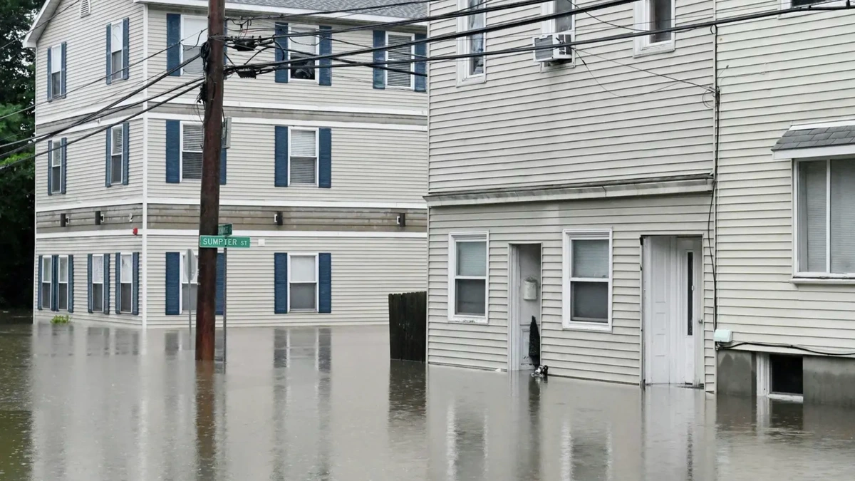
Albany flooding July 29, 2026. Credit: MyCoast
A National Weather Service (NWS) Public Information Statement compiled 48-hour rainfall reports from multiple observing networks across eastern New York following the heavy rainfall event.
The highest reported rainfall total was 299.47 mm (11.79 inches) at Schodack in Rensselaer County. Other significant totals included 257.56 mm (10.14 inches) at Schodack Landing, 207.01 mm (8.15 inches) at South Schodack and 181.61 mm (7.15 inches) at Troy.
The reporting periods ended between 05:53 and 07:30 LT on July 30, depending on the observing location.
Floodwaters from the Muitzes Kill also destroyed a historic grist mill on Muitzeskill Road in Schodack. Local broadcasters described the structure as approximately 300 years old, although its precise construction date has not been independently confirmed. Owner Andy Klein said water undermined the building before he watched it collapse.

Albany International Airport recorded 138.43 mm (5.45 inches) of rain on July 29, making it the city’s second-wettest calendar day in daily records dating to 1874. The total was 3.81 mm (0.15 inches) below the calendar-day record of 142.24 mm (5.60 inches), set during Tropical Storm Floyd on September 16, 1999.
The July 29 rainfall also exceeded the 119.13 mm (4.69 inches) measured during Hurricane Irene on August 28, 2011.
Farther south in New York’s Mid-Hudson region, Putnam Valley Supervisor Alison Jolicoeur declared a state of emergency effective at 16:00 LT on July 29. The declaration cited flash flooding, torrential rainfall, numerous road and bridge closures and other storm-related conditions that threatened public safety.
The state of emergency remains in effect for up to 30 days unless rescinded earlier.
Emergency Order No. 1 separately prohibited unnecessary travel for five days on Cimarron Road, Horton Hollow Road, Canopus Hollow Road, Tinker Hill Road, Reichert Street and Camp Collins Road unless modified or rescinded before its scheduled expiration.
Permitted travel includes police, fire, emergency medical services and other emergency vehicles, municipal highway and public works vehicles engaged in emergency response or repair operations, and utility crews restoring or protecting critical infrastructure.
Residents, property owners, tenants and their agents may also use the restricted roads when access is required to reach their residences or properties or to obtain medical care, prescription medication, food, fuel or other essential supplies, or to care for dependents or animals.
Essential emergency personnel may travel on the restricted roads when required to perform life-safety operations, emergency response, utility restoration or other critical municipal functions.
The declaration directs all town departments and agencies to take the actions necessary to protect life, property and public infrastructure and to provide emergency assistance.
NWS Albany is monitoring another period of rainfall expected from Sunday afternoon into Monday. Forecasters said uncertainty remained regarding the exact position and timing of the heaviest rainfall, with isolated flooding possible Sunday and isolated to scattered flash flooding possible Monday, particularly from the Interstate 90 corridor southward.
References:
1 Public Information Statement: Precipitation reports – NWS Albany – July 30, 2026
2 Weather Story: Albany rainfall record and Sunday-Monday rainfall outlook – NWS Albany – July 31, 2026
3 State of Emergency declared in the Town of Putnam Valley – Town of Putnam Valley – July 29, 2026

I’m a science journalist and researcher at The Watchers, contributing to the Epicenter edition, where I cover peer-reviewed scientific research and emerging discoveries across Earth and space sciences. With a background in astronomy and a passion for environmental science, I’ve worked in shark and coral conservation in Fiji, conducting reef and shark-behavior research, contributing to mangrove restoration, and earning PADI Open Water and Coral Reef Certifications. I bring a blend of scientific rigor and storytelling to illuminate the discoveries shaping our planet and beyond.
Published in the last 24 hours
- Forecasters say this winter’s El Niño could reach historic strength, but the last one that big, nicknamed Godzilla in 2015–16, left Los Angeles with about two-thirds of its normal rain while storms pounded the Pacific Northwest Epicenter
- Winds circling the North Pole have slowed sharply this month, the same kind of disruption that in January 2019 split the polar vortex and sent Chicago to minus 23°F, cold enough that rail crews ran flames along the tracks Epicenter
- In April 2014, golden-winged warblers in the mountains of Tennessee, songbirds weighing about as much as four dimes, fled their breeding grounds a day or two before a tornado outbreak and flew hundreds of miles south, while the scientists tracking them sheltered in a Waffle House Epicenter
- After record Nordic heatwave, Swedish researchers to recreate indoor heat to study older adults Epicenter
