
M5.6 earthquake in Jamaica’ Hope Bay leads to building collapse and emergency service strain
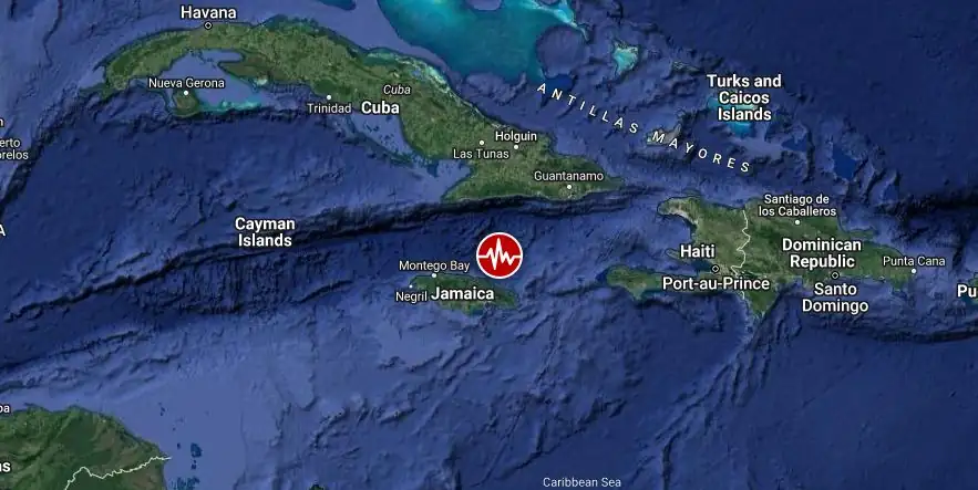
Image credit: TW/SAM, Google
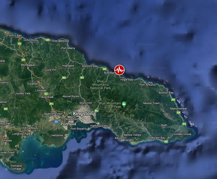
A shallow earthquake registered by the Earthquake Unit of the University of West Indies as M5.6 hit Hope Bay, Jamaica at 15:57 UTC (10:57 LT) on October 30, 2023. The agency is reporting a depth of 18 km (11.2 miles). The USGS is reporting it as M5.4, EMSC as M5.5, and INGV and Ayiti-Seismes (Haiti) as M5.8.
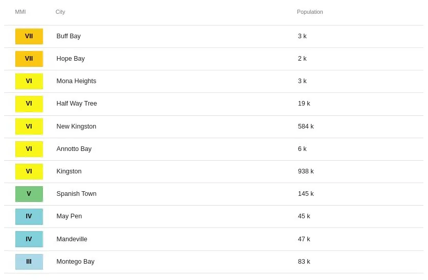
According to the USGS, the epicenter was located 4.4 km (2.7 miles) WNW of Hope Bay (population 1 666), 16.7 km (10.4 miles) WNW of Port Antonio (population 14 400), and 29.3 km (18.2 miles) SE of New Kingston (population 583 958), St. Andrew, Jamaica.
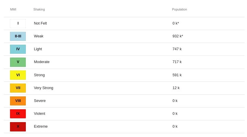
12 000 people are estimated to have felt very strong shaking, 591 000 strong, 717 000 moderate, and 747 000 light.
The USGS issued a Yellow alert for shaking-related fatalities and economic losses. Some casualties and damage are possible and the impact should be relatively localized. Past yellow alerts have required a local or regional-level response.
Estimated economic losses are less than 1% of GDP of Jamaica.
Overall, the population in this region resides in structures that are vulnerable to earthquake shaking, though resistant structures exist. The predominant vulnerable building types are mud wall and informal (metal, timber, GI etc.) construction.
In the aftermath of the earthquake that struck Jamaica on October 30, 2023, extensive damage and disruptions were reported across various regions of the island. One significant incident was the collapse of a three-story concrete house in Portland. Fortunately, the couple residing in the house were away in Kingston visiting relatives, avoiding potential casualties.
The natural disaster also led to considerable infrastructural damage. In Portland, the offices of the Municipal Corporation experienced structural damage, affecting their functionality. Multiple roadways across the island were also impacted due to landslides, particularly in rural St. Andrew. Roads such as Cane River Road, Dallas Castle Road, and Greenvale Road have been reported as compromised.
In response to the crisis, the Jamaica Constabulary Force (JCF) has been actively coordinating with other emergency services to assist the public. Traffic signals, notably in the Corporate Area, were affected, prompting the deployment of police officers to maintain public safety and order. The JCF has urged the public to comply with the instructions from police and other emergency personnel.
The health sector also experienced strain, with Kingston Public Hospital witnessing a surge in emergency cases. The hospital reported an influx of individuals suffering from panic and asthma attacks triggered by the earthquake. The volume of cases was such that the accident and emergency department was overwhelmed, leading to medical staff treating patients outside the facility.
Additionally, the HEART/NSTA Trust corporate building located at the intersection of Oxford and Belmont roads in St. Andrew announced the closure of all its physical locations due to earthquake-related damage. However, the agency confirmed that online services would continue to be available to the public.
Estimated population exposure to earthquake shaking
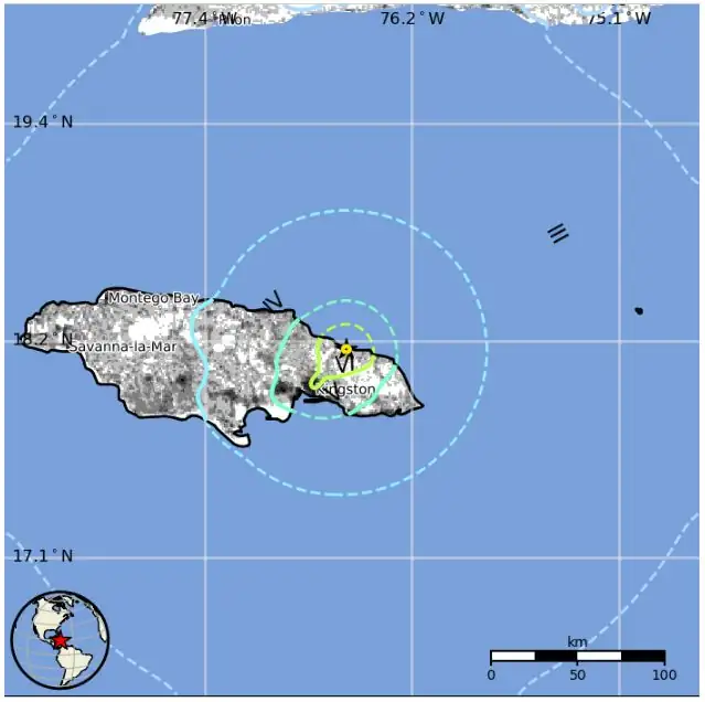
Selected cities exposed
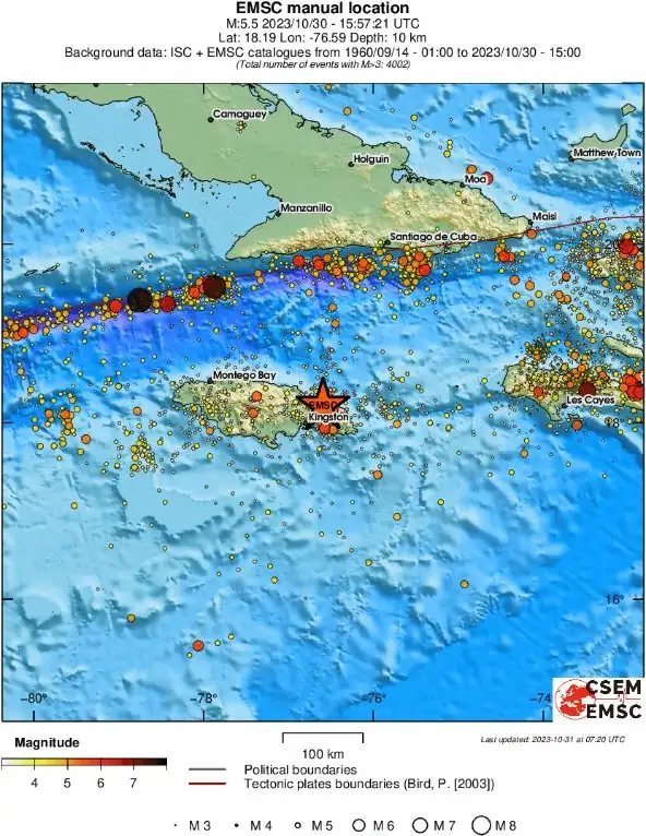
Regional seismicity
I'm a dedicated researcher, journalist, and editor at The Watchers. With over 20 years of experience in the media industry, I specialize in hard science news, focusing on extreme weather, seismic and volcanic activity, space weather, and astronomy, including near-Earth objects and planetary defense strategies. You can reach me at teo /at/ watchers.news.
Commenting rules and guidelines
We value the thoughts and opinions of our readers and welcome healthy discussions on our website. In order to maintain a respectful and positive community, we ask that all commenters follow these rules.