
Tropical Cyclone “Biparjoy” heading toward Pakistan – India border region
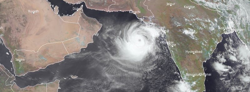
Featured image: Tropical Cyclone "Biparjoy" at 08:15 UTC on June 12, 2023. Credit: EUMETSAT/Meteosat-9, RAMMB/CIRA, The Watchers
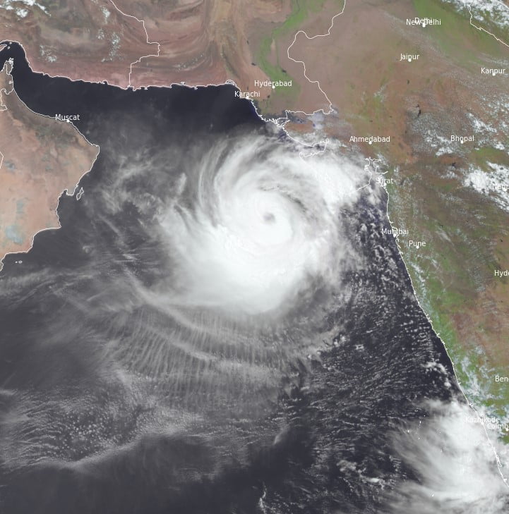
Tropical Cyclone “Biparjoy” formed in the Arabian Sea on June 6, 2023, as the second named storm of the 2023 North Indian Ocean cyclone season. The system is moving northward, threatening the coasts of Pakistan and neighboring Saurashtra and Kutch, India.
The storm, as of 03:00 UTC on June 12, is likely to gain momentum, potentially causing significant damage as it moves closer to the coastline.
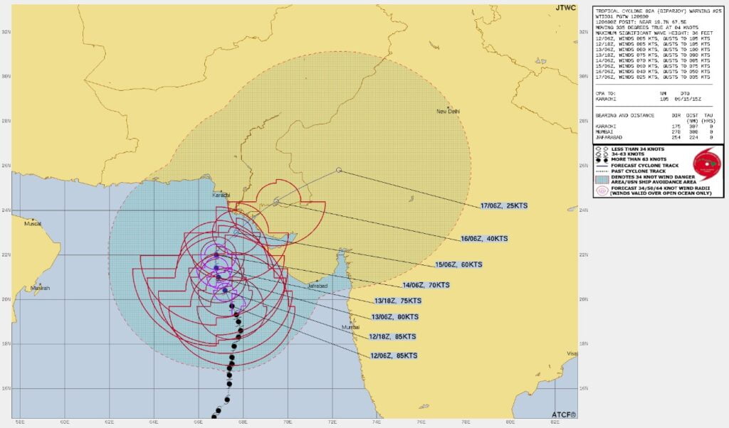
At the time, the center of Extremely Severe Cyclonic Storm “Biparjoy” was approximately 320 km (198.8 miles) southwest of Porbandar, 360 km (223.7 miles) south-southwest of Devbhumi Dwarka, India, 440 km (273.4 miles) south of Jakhau Port, India, 440 km (273.4 miles) south-southwest of Naliya, India and 620 km (385.2 miles) south of Karachi, Pakistan.
The system had a maximum sustained wind speed of 165 – 175 km/h (102 – 108 mph), gusting to 195 km/h (121 mph). It was moving N at a speed of 7 km/h (4.3 mph).
Biparjoy is forecast to continue its northward trajectory until the morning of June 14. Post this, the cyclone is expected to shift direction, moving north-northeastwards. It is anticipated to cross the Saurashtra and Kutch coasts and adjoining Pakistan between Mandvi, Gujarat and Karachi, Pakistan, near Jakhau Port, Gujarat, by 12:00 LT on June 15.
The cyclone is expected to bring heavy rainfall across the districts of Kutch, Devbhumi Dwarka, Porbandar, Jamnagar, Rajkot, Junagarh, and Morbi in Gujarat starting from June 14. Rainfall intensity is predicted to increase by June 15, with extremely heavy downpours expected in Kutch, Devbhumi Dwarka, and Jamnagar. North Gujarat and south Rajasthan are likely to experience moderate to heavy rainfall on June 16.
Gale wind speeds are also forecasted to escalate over the Arabian Sea region, reaching between 165 – 175 km/h (102 – 108 mph) and gusting to 195 km/h (121 mph) on June 12, progressively decreasing over the following days. Squally winds are likely over the west-central Arabian Sea and adjoining areas. Along Saurashtra and Kutch coasts, gale wind speeds are likely to reach between 125 – 135 km/h (77 – 83 mph), gusting to 150 km/h (93 mph) from the morning of June 15, gradually decreasing thereafter.
Sea condition and storm surge warning
Sea conditions over the northeast and east-central Arabian Sea are expected to be phenomenal from June 12 to 15, improving thereafter. Along and off the Saurashtra and Kutch coasts, the sea is predicted to be rough until the morning of June 14, escalating to high or phenomenal levels until June 15 noon, and improving thereafter. A storm surge of about 2 – 3 m (6.5 – 9.8 feet) above the astronomical tide is anticipated to inundate low-lying areas during landfall.
Potential damage and advisories
The impact of Biparjoy on June 15 is likely to cause extensive damage in Kutch, Devbhumi Dwarka, Porbandar, Jamnagar, Morbi, Junagarh, and Rajkot districts of Gujarat. Total destruction of thatched houses, damage to Pucca and Kutcha houses, roads, power, and communication lines is expected. Widespread damage to crops and small boats is also probable.
Fishermen are advised to suspend operations over the east-central and west-central Arabian Sea until June 15 and the northeast Arabian Sea from June 12 to 15. Those at sea are advised to return to the coast.
Other suggestions include evacuation from coastal areas, judicious regulation of rail and road traffic, and restricted tourism activities in the affected regions. All ports along the west coast of India and naval bases are advised to take necessary precautions. The public is advised to remain indoors.
References:
1 Tropical Cyclone “Biparjoy” – RSMC New Delhi update at 06:00 UTC on June 12, 2023
The Watchers team and our contributors bring the latest on extreme weather, earthquakes, volcanic eruptions, space weather, and all things science. We're all about making sense of the natural world and keeping you informed on what’s happening. Got a tip or a question? Hit us up using the form at newstips!
Commenting rules and guidelines
We value the thoughts and opinions of our readers and welcome healthy discussions on our website. In order to maintain a respectful and positive community, we ask that all commenters follow these rules.