
Widespread record-breaking morning lows to bring first freeze of the season to parts of the Midwest and South, U.S.
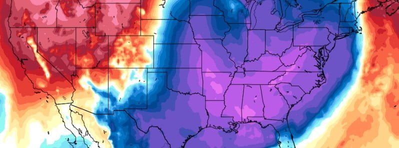
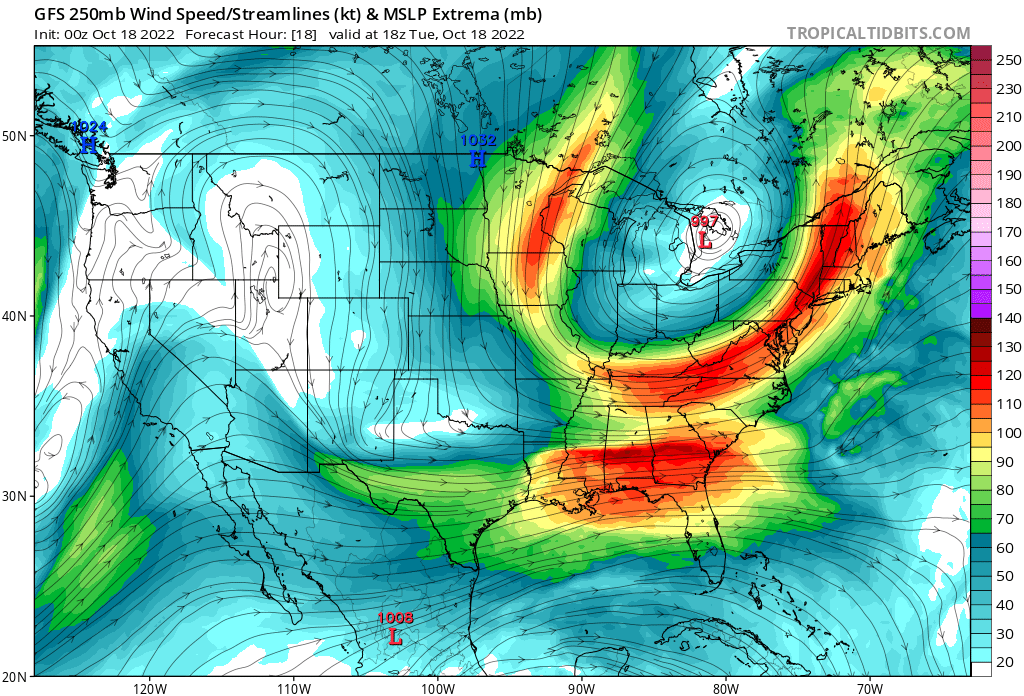
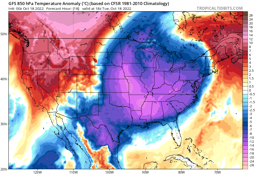
Image credit: Tropical Tidbits, GFS
An early-season Great Lakes storm is producing heavy snow, high winds, and large waves. Cold air will grip much of the eastern 2 thirds of the United States in the days ahead, bringing much below-normal temperatures to the East Coast and the first freeze of the season to portions of the Midwest and South.
A deep upper-level low pressure system currently sits over the Great Lakes as a strong cold front continues to push south and east of the Gulf and Atlantic coasts, leading to a combination of chilly, well-below-normal temperatures for much of the eastern 2 thirds of the United States, as well as wintry precipitation for the Great Lakes, NWS forecaster Putnam noted.1
A cold continental airmass has begun to settle in as high pressure builds southward over the central and southern U.S.
Widespread, well-below-normal high and low temperatures are forecast through the short-term period (Wednesday evening LT, October 19), with some upwards of 14 °C (25 °F) below normal and many record-tying/breaking temperatures possible.
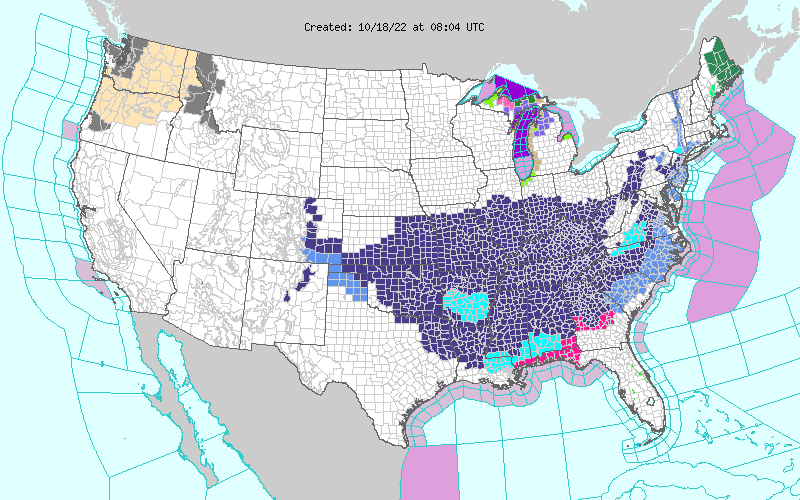
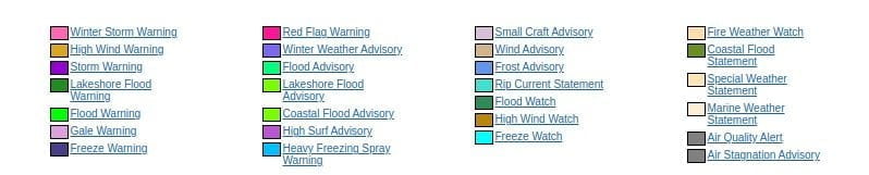
Freeze Warnings are in effect across broad portions of the Central Plains, Middle Mississippi Valley, Ohio Valley, Tennessee Valley, Mid-South, and Central/Southern Appalachians.
Freeze Watches are in effect further south from northern portions of the Southern Plains east through the Lower Mississippi Valley and into Piedmont.
“Lows in the mid-20s to low 30s [(~)-4 to 1 °C] are currently forecast for locations in the Freeze Warnings Tuesday morning, October 18 with lows in the low to mid-30s [~2 °C] for areas in the Freeze Watches on Wednesday morning,” Putnam said.
Areas to the north of the Freeze Watches and Warnings, despite already having seen their first freeze, will still experience well below normal, frigid temperatures Tuesday, with highs in the upper-30s to low 40s [3 to 6 °C] for the Northern Plains and Upper Great Lakes and low to mid-40s [~7 °C] for the Middle Missouri Valley east to the Lower Great Lakes.
Highs on Wednesday should warm by about 3 – 6 °C (~5 – 10 °F) across the region.
Further south, while a widespread freeze is not currently expected, morning lows on Wednesday will bottom out in the upper-30s to low 40s [~3 to 6 °C] across much of the Gulf Coast.
In addition to the chilly temperatures, additional waves of low pressure rotating around the broader upper-level low will continue strong/gusty northwesterly winds across portions of the Great Lakes with a wintry mix of rain and snow showers expected through Wednesday.
Any snow accumulations should generally remain on the lighter side with the exception of the Upper Great Lakes, particularly the Upper Peninsula of Michigan.
Snow showers today will taper off through the day tomorrow, with total accumulations upwards of 15 – 30 cm (6 – 12 inches) possible for some higher elevation, inland locations.
Heavy rain is forecast to the east of the cold front as it pushes through Maine during the day Tuesday.
Anomalously high moisture from the Gulf Stream will be advected northward ahead of the front and help to enhance rain rates/rainfall totals for showers and thunderstorms along the front.
References:
1 Short Range Forecast Discussion – NWS Weather Prediction Center College Park MD – 438 PM EDT Mon Oct 17 2022
I'm a dedicated researcher, journalist, and editor at The Watchers. With over 20 years of experience in the media industry, I specialize in hard science news, focusing on extreme weather, seismic and volcanic activity, space weather, and astronomy, including near-Earth objects and planetary defense strategies. You can reach me at teo /at/ watchers.news.
Commenting rules and guidelines
We value the thoughts and opinions of our readers and welcome healthy discussions on our website. In order to maintain a respectful and positive community, we ask that all commenters follow these rules.