
Large surface rupture identified after M5.1 earthquake hits North Carolina, the largest in nearly 100 years
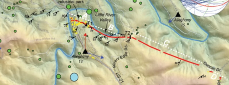
Image credit: Paula M. Figueiredo et al. / The Geological Society of America
A co-seismic surface rupture was identified along a 2 km (1.2 miles) long traceable zone after M5.1 earthquake hit North Carolina in 2020 – the largest to hit the state in nearly 100 years. The rupture exposed a previously unknown fault in the earth, representing the first documented surface rupture earthquake in the eastern United States.
The quake hit at 08:07 EDT (12:07 UTC) on August 9, 2020, approximately 3 km (1.8 miles) south of Sparta, North Carolina and was felt throughout much of the eastern United States. This is the largest earthquake to hit North Carolina in nearly 100 years and the largest in the eastern United States since the 2011 Mw 5.8 Mineral, Virginia quake.
While quakes in North Carolina aren’t unusual, especially near the Appalachian mountain range, this quake was unique as it was a shallow event that caused a ground surface rupture on a previously unknown fault line.
Most notably, the earthquake generated the first documented co-seismic surface rupture by faulting in the eastern United States.
The co-seismic surface rupture was identified along a 2 km (1.2 miles) long traceable zone of predominantly reverse displacement, with folding and flexure generating a scarp averaging 8 to 10 cm (3 – 3.9 inches) high with a maximum observed height of about 25 cm (9.8 inches), said authors of the study published last month in The Geological Society of America.
“Widespread deformation south of the main surface rupture includes cm-dm–long and mm-cm–wide fissures. Two trenches excavated across the surface rupture reveal that this earthquake propagated to the surface along a preexisting structure in the shallow bedrock, which had not been previously identified as an active fault.”
Surface ruptures by faulting are rarely reported for earthquakes with magnitudes below 6, and hence the Sparta earthquake provides an opportunity to improve seismic hazard knowledge associated with these moderate events.

Furthermore, this earthquake occurred in a very low strain rate intraplate setting, where earthquake surface deformation, regardless of magnitude, is sparse in time and rare to observe and characterize.
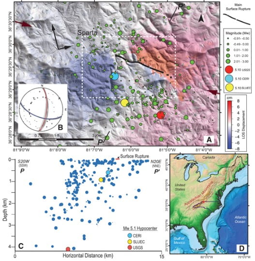
The surface rupturing Mw 5.1 Sparta earthquake occurred on a WNW-striking previously unknown structure, now named the Little River fault (Hill et al., 2020). The main event generated peak ground accelerations of at least 0.2 g with an MMI of VI–VII in Sparta.
Roads, utility lines, and masonry structures were damaged, including the collapse of walls and chimneys and the cracking and shifting of foundations, causing North Carolina’s governor to declare a local state of emergency and the North Carolina General Assembly to provide U.S.$24M for earthquake recovery.
Fortunately, there were no casualties or significant damage to major infrastructures.
The mainshock hypocenter and focal mechanism have been estimated independently by several groups.
Horton et al. (2021) at the Center for Earthquake Research and Information, University of Memphis (CERI), calculated a first-motion focal mechanism consistent with a N108°-striking 60° SW-dipping nodal plane, with a 24° rake (Fig. 1B) and a best-fitting centroid depth of 0.6 km (0.4 miles) based on modeling regional waveforms and an epicenter location (36.488° N, 81.106° W) using a grid search procedure.
The Saint Louis University Earthquake Center calculated a centroid depth of 1 km (0.6 miles) with a N115°, 50° SW nodal plane and rake of 40° based on best-fit modeling of regional waveforms (SLUEC, 2020).
Analysis by SLUEC (2020) and Horton et al. (2021) yield similar results consistent with a shallow (<1 km / 0.6 miles) left-lateral reverse rupture on a SW-dipping plane.
These results, however, differ from the preferred USGS solution, which places the event deeper (4.1 ± 1.8 km / 2.5 ± 1.1 miles), with a nodal plane striking N176°, 48° W and a rake of 136°.
The earthquake sequence started with eight foreshocks with Mw 1.8–2.6 during the 24 hours before the mainshock, followed by at least 300 aftershocks over the next six months, the largest being an Mw 2.9 on August 11.
The aftershock sequence was mainly recorded with a real-time broadband seismic array installed by CERI 48 hours after the mainshock.
Most aftershocks were Mw <1.5, shallower than 3 km (1.8 miles), and distributed across a 40 km2 (15 mi2) elliptical area with its major axis trending NW to WNW (USGS Catalog August–February 2021).
Reference:
“The Mw 5.1, 9 August 2020, Sparta Earthquake, North Carolina: The First Documented Seismic Surface Rupture in the Eastern United States” – Paula M. Figueiredo et al. – The Geological Society of America, 2022 – https://doi.org/10.1130/GSATG517A.1 – OPEN ACCESS
I'm a dedicated researcher, journalist, and editor at The Watchers. With over 20 years of experience in the media industry, I specialize in hard science news, focusing on extreme weather, seismic and volcanic activity, space weather, and astronomy, including near-Earth objects and planetary defense strategies. You can reach me at teo /at/ watchers.news.
Commenting rules and guidelines
We value the thoughts and opinions of our readers and welcome healthy discussions on our website. In order to maintain a respectful and positive community, we ask that all commenters follow these rules.