
Tropical Cyclone “Tiffany” to make landfall over the far north Queensland, Australia
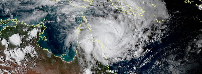
Featured image: Tropical Cyclone "Tiffany" at 07:20 UTC on January 9, 2022. Credit: JMA/Himawari-8, RAMMB/CIRA, TW
Tropical Cyclone "Tiffany" formed in the Coral Sea on January 9, 2022, as the 5th named storm of the 2021/22 Australian region cyclone season. Tiffany is expected to bring damaging to destructive winds and heavy rain to communities in far north Queensland from the morning of January 10, 2022 (LT). Parts of Queensland already saw major flooding this week after prolonged heavy rainfall brought by Ex-Tropical Cyclone "Seth" described by BOM as incredibly rare.
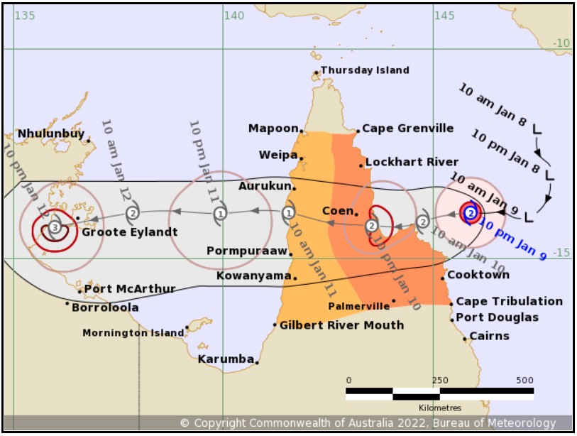
- Tiffany has strengthened to category 2 cyclone on the Australian scale as it approaches the Cape York Peninsula.
- Landfall is expected between Cooktown and Lockhart River, with the timing dependent on whether Tiffany moves south or north of Cape Melville.
- The system is expected to move into the Gulf of Carpentaria on Tuesday and re-intensify quickly as it moves towards the Northern Territory coast.
- A severe tropical cyclone coastal impact on the Northern Territory coast is possible on Wednesday, January 12 or Thursday, January 13.
As of 17:45 UTC on January 9 (04:46 AEST, January 10), Tiffany was a category 2 tropical cyclone moving W at 18 km/h (11 mph) with sustained winds near the center of 95 km/h (59 mph) and wind gusts to 130 km/h (81 mph), according to the Australian Bureau of Meteorology (BOM).1
Tiffany's center was located about 170 km (105 miles) NNE of Cooktown and 220 km (136 miles) ESE of Lockhart River.
The cyclone continues to strengthen as it approaches the far north Queensland coast.
Landfall is expected between Cooktown and Lockhart River, with the timing dependent on whether Tiffany moves south or north of Cape Melville, BOM said.
Tiffany will weaken slightly over land but may maintain tropical cyclone strength as it moves westward across the Cape.
The system is then expected to move into the Gulf of Carpentaria on Tuesday and re-intensify quickly as it moves towards the Northern Territory coast.
A severe tropical cyclone coastal impact on the Northern Territory coast is possible on Wednesday, January 12 or Thursday, January 13.
Hazards
Gales with gusts to 110 km/h (68 mph) will develop between Cape Tribulation and Coen, including Cooktown, early Monday as Tiffany approaches the coast. These gales may extend north to Lockhart River and Cape Grenville if the cyclone takes a more northerly track.
Destructive wind gusts to 130 km/h (80 mph) are expected later on Monday as the center of the cyclone makes landfall.
Gales with gusts to 100 km/h (60 mph) may extend westward across the Cape York Peninsula between Gilbert River Mouth and Mapoon, including Weipa, and Pormpuraaw, on Tuesday.
Heavy rainfall is occurring in the warning area (Gilbert River Mouth to Mapoon and Cape Grenville to Cape Tribulation) and is expected to persist through Monday and into Tuesday as the system moves across Cape York Peninsula. Widespread 24-hour totals of 100 to 150 mm (4 – 5.9 inches) are expected, with isolated 24-hour totals of 200 to 250 mm (7.9 – 9.8 inches) possible.
As the system crosses the coast, abnormally high tides are expected between Cape Tribulation and Lockhart River today, but the sea level should not exceed the highest tide of the year. Large waves are likely along the beachfront. Abnormally high tides are also expected on the western Cape York Peninsula during Tuesday and Wednesday.
People between Cape Tribulation and Coen, including Cooktown, should complete preparations quickly and be prepared to shelter in a safe place. People between Cape Grenville and Coen, including Lockhart River, and Mapoon to Gilbert River Mouth should take precautions and listen to the next advice at 8am AEST Monday.

Tropical Cyclone "Tiffany" at 07:20 UTC on January 9, 2022. Credit: JMA/Himawari-8, RAMMB/CIRA, TW
Parts of Queensland have already experienced flooding over the past couple of days after prolonged heavy rain brought by stalled Ex-Tropical Cyclone "Seth."
Major flooding hit Wide Bay and Burnett regions, causing highways to close and cutting off some towns.2
According to data provided by BOM, Marodian near Gympie received more than 670 mm (26.4 inches) in the 24 hours to 09:00 LT on January 8 with many other areas receiving at least 300 mm (11.8 inches).
One person drowned after his vehicle became submerged in floodwaters at Kanigan.
Police had been called to rescue 23 people in 11 vehicles. Eight of those were found safe yesterday, but the remaining 15 people were unaccounted for with rescue crews unable to access many areas.
BOM spokesman said this was extremely rare event as storms rarely sit in the same region for such a long period of time.
"This was incredibly rare," the spokesperson said. "The magnitude of what we saw really escalated during the night. It was a really evolving situation."
SES officials said they received more than 700 calls for help and launched 31 swift water rescues.
References:
1 BOM TROPICAL CYCLONE WARNING CENTRE – TROPICAL CYCLONE FORECAST TRACK MAP – Issued at 4:45 am AEST Monday 10 January 2022.
2 ‘Unexpected’ floods in Queensland leave 15 missing as ex-cyclone Seth wreaks havoc – The Guardian
I'm a dedicated researcher, journalist, and editor at The Watchers. With over 20 years of experience in the media industry, I specialize in hard science news, focusing on extreme weather, seismic and volcanic activity, space weather, and astronomy, including near-Earth objects and planetary defense strategies. You can reach me at teo /at/ watchers.news.
Commenting rules and guidelines
We value the thoughts and opinions of our readers and welcome healthy discussions on our website. In order to maintain a respectful and positive community, we ask that all commenters follow these rules.