
Volcanic unrest continues at White Island with vent temperature rise, New Zealand
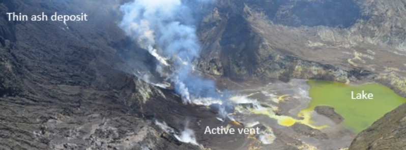
Image credit: GeoNet
Data acquired last week during an observation flight over White Island volcano shows a significant increase of the active vent temperature to just over 500 °C (932 °F). The state of moderate to heightened unrest continues at the volcano and the Volcanic Alert Level remains at Level 2.
GNS scientists undertook a visual observation flight of White Island volcano last week, including temperature measurements of the active vent area, GeoNet Duty Volcanologist Craig Miller notes.1
The maximum temperature measured in the active vent area was 516 °C (961 °F).
Temperatures ranged from 202 °C to 264°C (395 – 507 °F) from September to November 2021. Temperatures over 500 °C were last observed in July and August 2021. These observations are consistent with hot gas continuing to be released from the molten rock (magma) beneath the volcano.
Some minor amount of ash emission continues to be observed, as during most of previous flights, remaining limited to areas close to the active vents. Further intermittent ash emissions may continue to occur.
There was no evidence of further ash or liquid emission from the vent near the base of the 2019 landslide area. Gas emissions appeared lower but have not been quantified since November 18, 2021.
The water level of the lake has receded during a recent spell of fine weather.
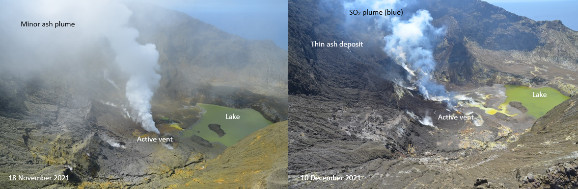
View of the active vent area at Whakaari/White Island on November 18 (left) and December 10, 2021 (right). Credit: GeoNet
The current level of activity is consistent with moderate to heightened levels of unrest. As such the Volcanic Alert Level remains at 2 and the Aviation Colour Code remains at Yellow.
Miller added that GeoNet's on-island equipment has degraded. This means that while they are getting some data, it is not real-time and it is not complete.
Geological summary
Uninhabited 2 x 2.4 km (1.2 x 1.5 miles) White Island, one of New Zealand's most active volcanoes, is the emergent summit of a 16 x 18 km (10 x 11.2 miles) submarine volcano in the Bay of Plenty about 50 km (31 miles) offshore of North Island.
The island consists of two overlapping andesitic-to-dacitic stratovolcanoes; the summit crater appears to be breached to the SE, because the shoreline corresponds to the level of several notches in the SE crater wall. Volckner Rocks, four sea stacks that are remnants of a lava dome, lie 5 km (3.1 miles) NNE.
Intermittent moderate phreatomagmatic and strombolian eruptions have occurred throughout the short historical period beginning in 1826, but its activity also forms a prominent part of Maori legends.
Formation of many new vents during the 19th and 20th centuries has produced rapid changes in crater floor topography. The collapse of the crater wall in 1914 produced a debris avalanche that buried buildings and workers at a sulfur-mining project.2
References:
1 VOLCANIC ALERT BULLETIN – WI – 2021/17 – Tue Dec 14 2021 12:00 PM; Whakaari/White Island Volcano
2 White Island – Geological summary – GVP
I'm a dedicated researcher, journalist, and editor at The Watchers. With over 20 years of experience in the media industry, I specialize in hard science news, focusing on extreme weather, seismic and volcanic activity, space weather, and astronomy, including near-Earth objects and planetary defense strategies. You can reach me at teo /at/ watchers.news.
Commenting rules and guidelines
We value the thoughts and opinions of our readers and welcome healthy discussions on our website. In order to maintain a respectful and positive community, we ask that all commenters follow these rules.