
Potent cold front to track through the Northeast, caution for those traveling during Thanksgiving week around the Great Lakes
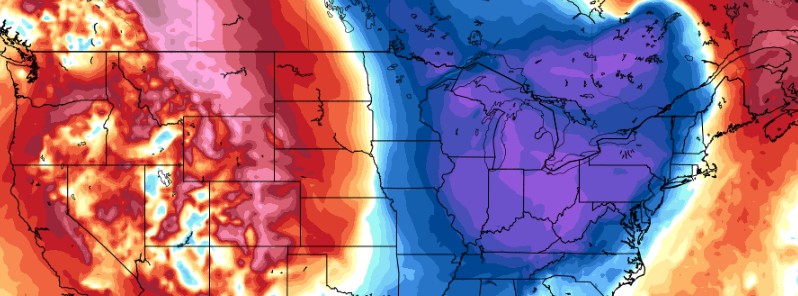
Image credit: GFS, TropicalTidbits
A sweeping cold front will bring widespread showers along the U.S. East Coast this week, followed by lake effect snow across the Great Lakes region.
As the holiday week gets off and running, much of the continental U.S. will be devoid of hazards the first half of the week due to an expansive dome of high pressure in the Nation's Heartland, NWS forecaster Mullinax said.1
Before high pressure builds in, however, an advancing cold front is responsible for passing up and down the Eastern Seaboard this morning. A few thunderstorms are also possible as the front traverses the Southeast today. Passing shower and thunderstorm activity will race into the northwest Atlantic by Monday evening.
In the wake of a potent cold front that will track through the Northeast early this week, the coldest air of the season will bring temperatures plummeting to levels more typical of mid-December to the Great Lakes region and Northeast, AccuWeather meteorologist Nicole LoBiondo reports.2
The wintry chill will also fuel the lake-effect snow machine, sending snow squalls barreling across the region.
The cold front associated with the storm that brought rain to the Ohio Valley and into the Northeast on November 21, will sweep through and move offshore over the Atlantic Ocean by Monday afternoon, LoBiondo notes.
"This front will usher in brisk conditions and lake-effect snow across the Great Lakes and interior Northeast."
"With the Great Lakes still ice-free, heavy lake-effect bands will be able to materialize as the cold air presses over the relatively warm water."
The heaviest snow is expected to fall downwind of Lake Superior in the eastern portion of Michigan’s Upper Peninsula and downwind of Lake Huron in Canada where 15 – 30 cm (6 -12 inches) of snow is in the forecast.
AccuWeather meteorologists caution those traveling during Thanksgiving week around the Great Lakes as the visibility could be quickly reduced to near zero during heavy lake-effect snow bands and gusty winds. In these types of situations, it is not uncommon for pileups to occur on highways, which could shut down roads for hours.
References:
1 Short Range Forecast Discussion – NWS Weather Prediction Center College Park MD – 242 AM EST Mon Nov 22 2021
2 Coldest air of the season, lake-effect snow set to blast Northeast – AccuWeather
I'm a dedicated researcher, journalist, and editor at The Watchers. With over 20 years of experience in the media industry, I specialize in hard science news, focusing on extreme weather, seismic and volcanic activity, space weather, and astronomy, including near-Earth objects and planetary defense strategies. You can reach me at teo /at/ watchers.news.
Commenting rules and guidelines
We value the thoughts and opinions of our readers and welcome healthy discussions on our website. In order to maintain a respectful and positive community, we ask that all commenters follow these rules.