
Super Typhoon “Surigae” (Bising) forces more than 100 000 to evacuate, Philippines
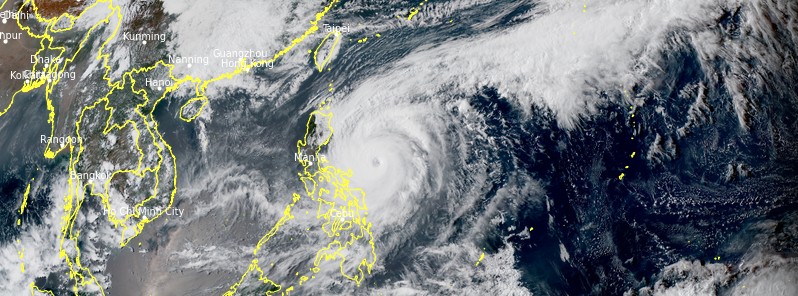
Featured image: Typhoon "Surigae" at 06:50 UTC on April 19, 2021. Credit: JMA/Himawari-8, RAMMB/CIRA/TW
Typhoon "Surigae" — known in the Philippines as Bising — brought more than 380 mm (15 inches) of rainfall across parts of Samar over the past 24 hours, causing floods and landslides and forcing more than 109 000 people to evacuate. While the rainfall totals in some areas are nearing 1 000 mm (40 inches), the threat is still not over as the storm slowly moves along the NE coast of the country.
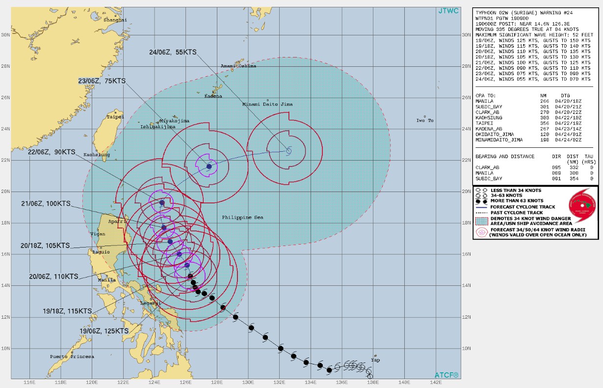
Surigae is the first Super Typhoon of the year and the strongest April tropical cyclone on record, surpassing the 2015 Typhoon "Maysak".
Its winds rapidly intensified from 145 km/h (90 mph) on Friday, April 16 to 305 km/h (190 mph) and 888 hPa on Sunday, April 18 — in just 36 hours.
According to local media reports, sporadic landslides and floods affected Catanduanes, Albay, Camarines Sur, and Sorsogon in the Bicol Region, forcing at least 109 815 people to evacuate.
On Monday, April 19, the typhoon continued bringing moderate to heavy, at times intense, rains over the Bicol Region, Northern Samar, Samar, Eastern Samar, Biliran, and the northern portion of Leyte.
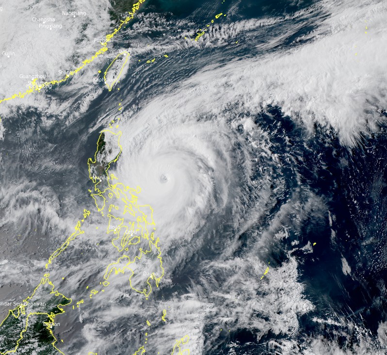
Typhoon "Surigae" at 06:50 UTC on April 19, 2021. Credit: JMA/Himawari-8, RAMMB/CIRA/TW
At 09:00 UTC today, Surigae had maximum sustained winds of 195 km/h (120 mph) and gusts to 240 km/h (150 mph), according to PAGASA. Its center was located about 500 km (310 miles) east of Infanta, Quezon, slowly moving north-northwestward.
Tropical Cyclone Wind Signal (TCWS) No. 2 remained hoisted over Catanduanes, the eastern portion of Camarines Sur (Siruma, Tinambac, Lagonoy, Garchitorena, Caramoan, Goa, Tigaon, San Jose, Presentacion, Sagnay, Buhi), the eastern portion of Albay (Tiwi, Malinao, Tabaco City, Malilipot, Santo Domingo, Bacacay, Rapu-Rapu, Legazpi City, Manito), and the eastern and central portions of Sorsogon (Castilla, Sorsogon City, Prieto Diaz, Gubat, Barcelona, Casiguran, Juban, Magallanes, Bulan, Bulusan, Irosin, Santa Magdalena, Matnog), Northern Samar, the northern portion of Samar (Santo Nino, Almagro, Tagapul-An, Calbayog City, Santa Margarita, Gandara, Matuguinao, San Jose de Buan, San Jorge, Tarangnan, Pagsanghan, Catbalogan City, Paranas, Jiabong, Motiong, Hinabangan, San Sebastian), and the northern portion of Eastern Samar (San Julian, Sulat, Taft, Can-Avid, Dolores, Maslog, Oras, San Policarpo, Arteche, Jipapad).
TCWS No. 1 was hoisted over the eastern portion of Cagayan (Lal-Lo, Gattaran, Alcala, Baggao, Amulung, Solana, Iguig, Tuguegarao City, Enrile, Peñablanca, Camalaniugan, Aparri, Buguey, Santa Teresita, Gonzaga, Santa Ana), Isabela, Quirino, the northern and central portions of Aurora (Baler, Dipaculao, Dinalungan, Casiguran, Dilasag), the eastern portion of Quezon (Calauag, Guinayangan, Tagkawayan, Buenavista, San Narciso, San Andres) including Polillo Islands, Camarines Norte, the rest of Camarines Sur, the rest of Albay, the rest of Sorsogon, and Masbate including Burias and Ticao Islands, the rest of Samar, the rest of Eastern Samar, Biliran, Leyte, and the northern portion of Cebu (Tabogon, Borbon, San Remigio, Bogo City, Medellin, Daanbantayan) including Bantayan and Camotes Islands.
Over the next 24 hours, the northeasterly wind flow enhanced by Surigae will also bring strong breeze to near gale conditions with higher gusts over most of northern Luzon, Aurora, and the rest of Quezon province that are not under TCWS, PAGASA said.
Very rough to very high seas will be experienced over the eastern seaboard of Luzon, and rough to very high seas still prevail over the northern and eastern seaboards of Eastern Visayas. Sea travel is risky for all types of seacraft.
Rough to very rough seas remain over the northern and western seaboards of northern Luzon, and the eastern seaboard of Caraga.
Rough seas also continue over the remaining seaboards of localities where TCWS are in effect and the eastern seaboard of Davao Oriental. Sea travel is risky for small seacrafts.
Moderate to rough seas continue over the western seaboard of Central Luzon.
PAGASA advised mariners of small seacraft not to venture out over these waters.
I'm a dedicated researcher, journalist, and editor at The Watchers. With over 20 years of experience in the media industry, I specialize in hard science news, focusing on extreme weather, seismic and volcanic activity, space weather, and astronomy, including near-Earth objects and planetary defense strategies. You can reach me at teo /at/ watchers.news.
Commenting rules and guidelines
We value the thoughts and opinions of our readers and welcome healthy discussions on our website. In order to maintain a respectful and positive community, we ask that all commenters follow these rules.