
Powerful earthquakes, including M8.1, M7.4 and M6.1 hit the Kermadec Islands – Tsunami warnings issued
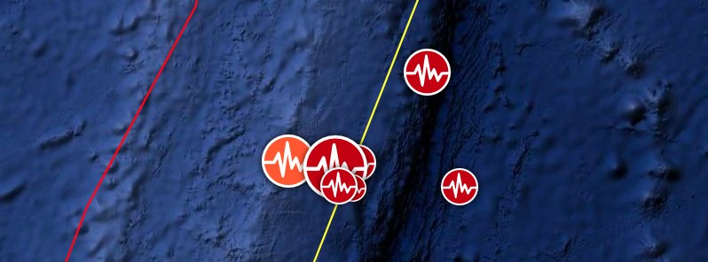
Image credit: TW/SAM, Google
Powerful earthquakes are shaking the Kermadec Islands region of New Zealand on March 4, 2021, including M7.4 at 17:41 UTC, M8.1 at 19:28 (08:28 NZDT, March 5), and M6.1 at 20:25 UTC at depths between 10 and 55 km (6.2 and 34.2 miles).
The epicenters are located about 960 km (600 miles) SSW of Ohonua, Tonga, and 1 030 km (640 miles) NE of Northland, New Zealand.
There are no people living within 100 km (62 miles).
The National Emergency Management Agency (NEMA) of New Zealand has issued a TSUNAMI WARNING for New Zealand coastal areas.
There is a LAND and MARINE TSUNAMI THREAT.
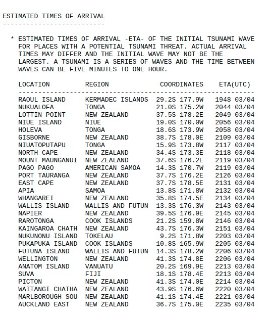
The first waves may reach New Zealand in the areas around Lottin Point at approximately 09:49 am NZDT (20:49 UTC, March 4). Tsunami activity will continue for several hours and the threat must be regarded as real until the warning is canceled, NEMA said.
"Evacuation advice overrides the current COVID-19 Alert Level requirements. Listen to local Civil Defence authorities and follow any instructions. If you are told to evacuate do not stay at home. Stay 2 m [6.5 feet] away from others if you can and if it is safe to do so."
Credit: NEMA
NEMA Warning for New Zealand issued 20:49 UTC (09:49 LT on March 5):
***
This is a Tsunami Warning for New Zealand coastal areas following the magnitude 8.1 earthquake near KERMADEC ISLANDS REGION.
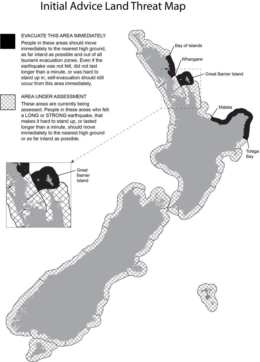
AREAS UNDER LAND AND MARINE WARNING:
Coastal inundation (flooding of land areas) is expected in the following areas:
The West Coast of the North Island from CAPE REINGA to AHIPARA.
The East Coast of the North Island from CAPE REINGA to WHANGAREI, from MATATA to TOLAGA BAY including Whakatane and Opotiki.
And GREAT BARRIER ISLAND.
Strong and unusual currents and unpredictable surges near the shore are expected in the following areas. This means a threat to beach, harbour, estuary and small boat activities.
The West Coast of the North Island from AHIPARA to MAKARA including the West Coast of Auckland, Manukau Harbour, New Plymouth, Whanganui and the Kapiti Coast.
The East Coast of the North Island from WHANGAREI to MATATA including Whangarei, the East Coast of Auckland, Waiheke Island, Waitemata Harbour and Tauranga, from TOLAGA BAY to LAKE FERRY including Gisborne and Napier.
The West and South Coasts of the South Island from FAREWELL SPIT to PUYSEGUR POINT including Westport, Greymouth and Hokitika.
The top of the South Island from FAREWELL SPIT to PORT UNDERWOOD including Nelson, Picton and the Marlborough Sounds.
The East and South Coasts of the South Island from the WAIPARA RIVER to the RAKAIA RIVER including Christchurch and Banks Peninsula, from the TAIERI RIVER to PUYSEGUR POINT including Invercargill.
And STEWART ISLAND.
And the CHATHAM ISLANDS.
There is no tsunami threat in all other areas.
The first waves may reach New Zealand in the areas around Lottin Point at approximately 9:49am New Zealand Daylight Time.
The severity of currents and surges will vary within a particular coastal area and over the period this warning is in effect.
The first wave may not be the largest. Tsunami activity will continue for several hours and the threat must be regarded as real until this warning is cancelled.
People in all New Zealand coastal areas should:
- Listen to the radio and/or TV for updates, or check www.civildefence.govt.nz
- Listen to local Civil Defence authorities and follow any instructions regarding evacuation of your area
- Stay out of the water (sea, rivers and estuaries, this includes boats)
- Stay off beaches and shore areas
- Do not go sightseeing
- Share this information with family, neighbours and friends
Evacuation advice overrides the current COVID-19 Alert Level requirements. Listen to local Civil Defence authorities and follow any instructions regarding evacuation of your area. If you are told to evacuate do not stay at home. Stay 2 metres away from others if you can and if it is safe to do so.
Only messages issued by the National Emergency Management Agency represent the official warning status for New Zealand. Pacific Tsunami Warning Center (PTWC) messages do not represent the official warning status for New Zealand.
This warning will remain in effect until a cancellation message is issued by the National Emergency Management Agency.
*** end of warning ***
Image credit: TW/SAM, Google
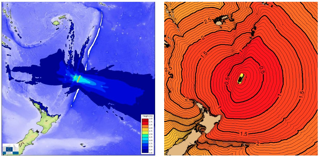
Image credit: GDACS
Hazardous tsunami waves from this earthquake are possible within the next three hours along some coasts of Kermadec Islands, Tonga, New Zealand, Niue, American Samoa, Samoa, Wallis and Futuna, Cook Islands, Tokelau, Vanuatu, and Fiji, PTWC said.
Persons located in threatened coastal areas should stay alert for information and follow instructions from national and local authorities.
The earthquake occurred as the result of reverse faulting in the Tonga-Kermadec subduction zone at a depth of ~22 km (14 miles), the USGS said.
The Tonga-Kermadec subduction zone extends north-northeast from the North Island of New Zealand for more than 2 500 km (1 550 miles) through Tonga to within 100 km (62 miles) of Samoa.
Focal mechanism solutions for the event indicate rupture occurred as a result of reverse faulting, either by low angle thrust motion on a west-dipping fault or by high angle reverse motion on an east-dipping fault.
The location, depth, and style of faulting are consistent with the earthquake having occurred on or near the west-dipping subducting plate interface between the Pacific and Australia plates.
The earthquake was preceded ~107 minutes by an M7.4 thrust earthquake located ~50 km (31 miles) west of the M8.1.
The proximity and timing of the two events indicates that the M7.4 was likely a foreshock of the M8.1 earthquake.
In terms of seismic moment, the M8.1 was ~11 x larger than the M 7.4 foreshock.
Additionally, a M7.3 oblique reverse faulting earthquake occurred ~6 hours prior to the M7.8 and ~900 km (560 miles) to the south. However, the spatial and temporal gap between these earthquakes likely indicates that static stress changes induced by the earlier M7.3 did not directly cause the M7.4 or M 8.1 earthquakes, according to the USGS.
Update
A 64 cm (2 feet) tsunami wave was recorded at Norfolk Island, off the east coast of Australia. East Cape, New Zealand registered waves around 35 to 40 cm (1.1 – 1.3 feet) while Great Barrier Island registered 15 to 20 cm (0.5 – 0.6 feet) high waves. Fiji and Tonga saw 13 cm (0.4 feet) and 6 cm (0.2 feet), respectively.
More footage of #tsunami rolling into Tokomaru Bay via @NewshubNZ pic.twitter.com/oGsTUNpFbw
— Luke Chandler (@LukeChandler) March 4, 2021
The USGS has registered 80 moderate to strong earthquakes in the area by 04:51 UTC on March 6, including M6.3, M7.4 and M8.1.
The M8.1 earthquake is the strongest earthquake to hit anywhere in the world since M8.2 near Fiji on August 19, 2018.
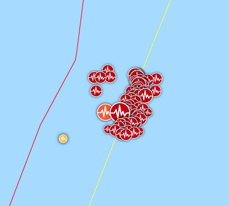
Kermadec Islands earthquakes in 7 days to 04:51 UTC on March 6. Credit: TW/SAM, Google
I'm a dedicated researcher, journalist, and editor at The Watchers. With over 20 years of experience in the media industry, I specialize in hard science news, focusing on extreme weather, seismic and volcanic activity, space weather, and astronomy, including near-Earth objects and planetary defense strategies. You can reach me at teo /at/ watchers.news.
Hi Can you post links of the two Tsunami wave images accredited to GDACS. I can’t find them
Thanks
https://www.gdacs.org/Tsunamis/report.aspx?eventid=1258647&episodeid=1362145&eventtype=EQ
Hi Thanks. I got to the right site but couldn’t find these. Most helpful
These earthquakes and recent volcano activity elsewhere,correlate with recent geomagnetic storm activity.G2 storm March 1st,G1 on the 2nd and G1 tomorrow,March 5th.
https://www.spaceweatherlive.com/en/reports/3-day-forecast.html
https://www.spaceweatherlive.com/en/news/view/432/20210303-geomagnetic-storming-coronal-hole.html
https://www.forbes.com/sites/jamiecartereurope/2021/03/02/northern-lights-likely-this-week-as-strongest-solar-storm-yet-in-suns-cycle-kicks-off-aurora-season/?sh=16eb4ae54875
Just what I was thinking! Do you have a Facebook and twitter account I can follow???