
Small earthquakes near Pinatubo, the volcano remains in a quiescent condition, Philippines
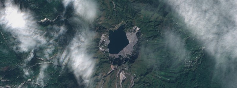
Image credit: Copernicus EU/Sentinel-2, RAMMB/CIRA, TW. Acquired January 15, 2021
A total of 860 imperceptible earthquakes have been detected by the Pinatubo Volcano Network and the Philippine Seismic Network from January 20 to 27, 2021. The Alert Level remains at 0. The last eruption of this volcano took place in 1993 (VEI 1). The volcano has a history of VEI 6 eruptions, the last one in 1991.
The quakes were located NE of Pinatubo Volcano in the vicinities of the City of Mabalacat, Pampanga. The strongest of these occurred on January 25 at depths of 15 to 28 km (9.3 – 17.4 miles) and ranged between ML1.0 and ML2.5, PHIVOLCS said.
Based on the general distribution of located events, these earthquakes were generated along a segment of the Sacobia Lineament, a fault that was last active during the post-eruption period of 1991.
"This development serves to remind us once again that several faults occur around the volcano and that these can generate earthquake activity that can be sometimes imperceptible and harmless but that can also sometimes be damaging," the institute said.
On April 22, 2019, a M6.1 earthquake on the southern foot slopes of Pinatubo Volcano shook the Central Luzon region and caused fatalities and substantial damages to buildings, roads, and other structures.
PHIVOLCS assured the public that Pinatubo Volcano remains at Alert Level 0 and in a quiescent condition.
"Although there is currently no threat from the above recent earthquake activity, communities and local government units surrounding the volcano, nonetheless, have to be reminded to be always prepared for both earthquake and volcanic hazards and to build on the lessons of what they have experienced in the past years."
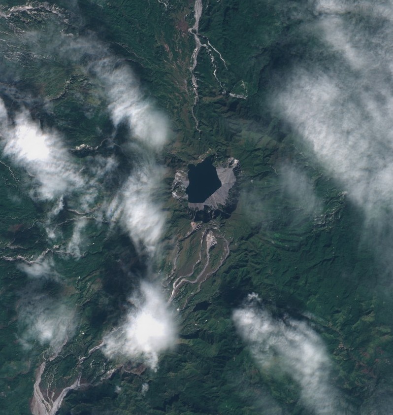
Image credit: Copernicus EU/Sentinel-2, RAMMB/CIRA, TW. Acquired January 15, 2021
The second-largest volcanic eruption of the 20th century, and by far the largest eruption to affect a densely populated area, occurred at this volcano on June 15, 1991 (VEI 6).
The eruption produced high-speed avalanches of hot ash and gas, giant mudflows, and a cloud of volcanic ash hundreds of miles across. The impacts of the eruption continue to this day, the USGS said.
The following is from USGS Fact Sheet 113-98 — The Cataclysmic 1991 Eruption of Mount Pinatubo, Philippines(USGS)
On July 16, 1990, a magnitude 7.8 earthquake — comparable in size to the great 1906 San Francisco earthquake — struck about 100 km (60 miles) northeast of Mount Pinatubo, shaking and squeezing the Earth's crust beneath the volcano.
This earthquake caused a landslide at the volcano, some local earthquakes, and a short-lived increase in steam emissions from a preexisting geothermal area, but otherwise, the volcano seemed to be continuing its 500-year-old slumber undisturbed.
In March and April 1991, however, magma rising toward the surface from more than 32 km (20 miles) beneath Pinatubo triggered small earthquakes and caused powerful steam explosions that blasted three craters on the north flank of the volcano.
Thousands of small earthquakes occurred beneath the volcano through April, May, and early June, and many thousand tons of noxious sulfur dioxide gas were also emitted.
First magma reached the surface from June 7 to 12, 1991.
Because it had lost most of the gas contained in it on the way to the surface, the magma oozed out to form a lava dome but did not cause an explosive eruption.
However, on June 12 — Philippine Independence Day — millions of cubic yars of gas-charged magma reached the surface and exploded in the reawakening volcano's first spectacular eruption.
The volcano exploded in a cataclysmic eruption on June 15, ejecting more than 5 km3 (1 mile3) of material.
The ash cloud from this climactic eruption rose 35 km (22 miles) into the air. At lower altitudes, the ash was blown in all directions by the intense cyclonic winds of a coincidentally occurring typhoon, and winds at higher altitudes blew the ash southwestward.
A blanket of volcanic ash and larger pumice lapilli blanketed the countryside. Fine ash fell as far away as the Indian Ocean, and satellites tracked the ash cloud several times around the globe.
Nearly 20 million tons of sulfur dioxide were injected into the stratosphere, and dispersal of this gas cloud around the world caused global temperatures to drop temporarily (1991 through 1993) by about 0.5 °C (1 °F).
Geological summary
Prior to 1991 Pinatubo volcano was a relatively unknown, heavily forested lava dome complex located 100 km (62 miles) NW of Manila with no records of historical eruptions.
The 1991 eruption, one of the world's largest of the 20th century, ejected massive amounts of tephra and produced voluminous pyroclastic flows, forming a small, 2.5 km (1.5 miles) wide summit caldera whose floor is now covered by a lake.
Caldera formation lowered the height of the summit by more than 300 m (984 feet).
Although the eruption caused hundreds of fatalities and major damage with severe social and economic impact, successful monitoring efforts greatly reduced the number of fatalities.
Widespread lahars that redistributed products of the 1991 eruption have continued to cause severe disruption. Previous major eruptive periods, interrupted by lengthy quiescent periods, have produced pyroclastic flows and lahars that were even more extensive than in 1991. (GVP)
I'm a dedicated researcher, journalist, and editor at The Watchers. With over 20 years of experience in the media industry, I specialize in hard science news, focusing on extreme weather, seismic and volcanic activity, space weather, and astronomy, including near-Earth objects and planetary defense strategies. You can reach me at teo /at/ watchers.news.
Commenting rules and guidelines
We value the thoughts and opinions of our readers and welcome healthy discussions on our website. In order to maintain a respectful and positive community, we ask that all commenters follow these rules.