Hurricane “Eta” forms in the Caribbean Sea, life-threatening storm surge, catastrophic flash flooding and landslides expected
Tropical Storm "Eta" formed on November 1, 2020, and strengthened into a hurricane at 09:00 UTC on Monday, November 2. The official forecast calls for rapid intensification and Eta could very well be a major hurricane when it makes landfall in Nicaragua. Since Eta is likely to be a very slow-moving system after it makes landfall, torrential rains and flooding will be a major threat. Life-threatening storm surge, damaging winds, flash flooding, and landslides are expected across portions of Central America.
- Eta is forecast to continue to strengthen, and it could become a major hurricane before it reaches the northeastern coast of Nicaragua early Tuesday, November 3, NHC forecasters noted.
- Through Friday evening, November 6, heavy rainfall from Eta will lead to catastrophic, life-threatening flash flooding and river flooding across portions of Central America, along with landslides in areas of higher terrain. Flash and river flooding is also possible across Jamaica, southeast Mexico, El Salvador, southern Haiti, and the Cayman Islands.
- A life-threatening storm surge, along with damaging waves, is expected along portions of the northeastern coast of Nicaragua near and to the north of where the center makes landfall.
- Water levels could reach as high as 3 to 4.5 m (10 to 15 feet) above normal tide levels in some parts of the hurricane warning area. Preparations to protect life and property should be rushed to completion.
- Eta is the 12th hurricane of the 2020 Atlantic hurricane season. Only 3 other hurricane season in the Atlantic have had 12+ hurricanes — 1969 (12), 2005 (15), and 2010 (12).
- Eta was named on November 1 as the 28th named storm of the 2020 Atlantic hurricane season to date. 2020 has now tied 2005 for the most named storms to form in the Atlantic in a single season on record, Dr. Philip Klotzbach noted.
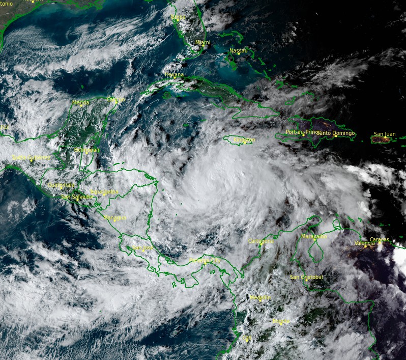
Hurricane "Eta" at 21:30 UTC on November 1, 2020. Credit: NOAA/GOES-16, RAMMB/CIRA
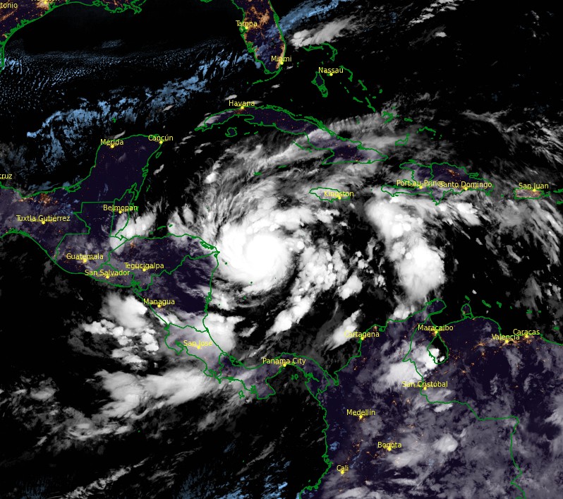
Hurricane "Eta" at 09:20 UTC on November 2, 2020. Credit: NOAA/GOES-16, RAMMB/CIRA
At 09:00 UTC on November 2, the center of Hurricane "Eta" was located 250 km (155 miles) E of Cabo Gracias aa Dios on Nicaragua/Honduras border, and about 285 km (175 miles) ENE of Puerto Cabezas, Nicaragua.
Its maximum sustained winds were 120 km/h (75 mph) and minimum central pressure 987 hPa.
A Hurricane Warning is in effect for the coast of Nicaragua from the Honduras/Nicaragua border to Sandy Bay Sirpi.
A Tropical Storm Warning is in effect for the northeastern coast of Honduras from Punta Patuca to the Honduras/Nicaragua border.
A Hurricane Watch is in effect for the northeastern coast of Honduras from Punta Patuca to the Honduras/Nicaragua border. A Tropical Storm Watch is in effect for the northern coast of Honduras from west of Punta Patuca westward to Punta Castilla.
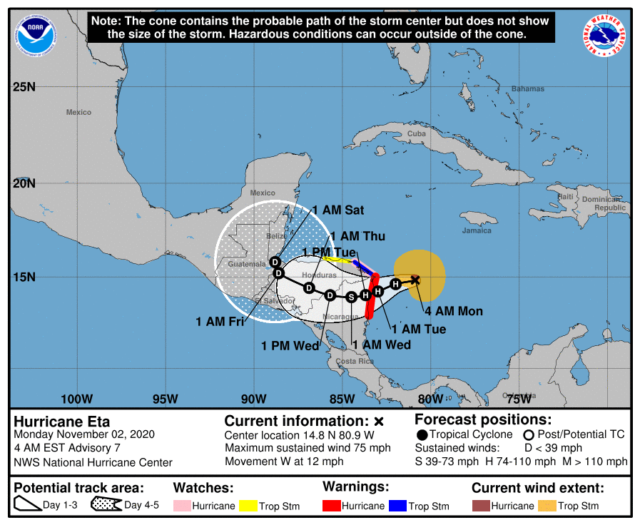
Eta is moving W at 19 km/h (12 mph) and this general motion is expected to continue through this morning (EST).
A slower motion toward the WSW is forecast by this afternoon (EST) and continuing into Tuesday, November 3.
On the forecast track, Eta is expected to approach to NE coast of Nicaragua this afternoon and make landfall within the Hurricane Warning area in Nicaragua by early Tuesday.
The center of Eta will then move farther inland over Nicaragua through early Wednesday, November 4 (EST).
Hurricane conditions are expected in the Hurricane Warning area beginning tonight (LT), with tropical storm conditions possible in this area by this afternoon. Tropical storm conditions are expected in the Tropical Storm Warning area by this afternoon, and hurricane conditions are possible in the Hurricane Watch area by early Tuesday. Tropical Storm conditions are possible in the Tropical Storm Watch area by early Tuesday.
NHC forecasters expect Eta to produce the following rainfall amounts through Friday evening:
Much of Nicaragua and Honduras: 380 to 635 mm (15 to 25 inches), isolated amounts of 890 mm (35 inches).
Eastern Guatemala and southern Belize: 255 to 510 mm (10 to 20 inches), isolated amounts of 635 mm (25 inches).
Portions of Panama and Costa Rica: 255 to 380 mm (10 to 15 inches), isolated amounts of 635 mm (25 inches).
Jamaica and southeast Mexico: 125 to 255 mm (5 to 10 inches), isolated amounts of 380 mm (15 inches) over southern areas.
El Salvador, Southern Haiti, and the Cayman Islands: 75 to 125 mm (3 to 5 inches), isolated amounts of 255 mm (10 inches).
This rainfall would lead to catastrophic, life-threatening flash flooding and river flooding, along with landslides in areas of higher terrain of Central America.
Flash flooding and river flooding would be possible across Jamaica, southeast Mexico, El Salvador, southern Haiti, and the Cayman Islands.
A dangerous storm surge will raise water levels by as much as 3 to 4.5 m (10 to 15 feet) above normal tide levels in areas of onshore winds along the coast of Nicaragua within the hurricane warning area, and 0.9 to 1.5 m (3 to 5 feet) above normal tide levels along the coast of Honduras within the tropical storm warning area.
Near the coast, the surge will be accompanied by large and destructive waves.
Swells generated by Eta are expected to affect portions of the coast of Central America and the Yucatan Peninsula of Mexico during the next few days. These swells are likely to cause life-threatening surf and rip current conditions.
"After landfall, weakening will occur while the cyclone interacts with the very mountainous terrain of Central America," NHC forecaster Pasch said.
"Even though official forecast points are shown through day 5, it is doubtful that the surface circulation could survive after being inland that long over the mountains of Nicaragua and Honduras. Although some of the global models are showing a cyclone over the northwestern Caribbean later this week and into the weekend, it is not certain whether this is Eta, or a new system that could form in that area."
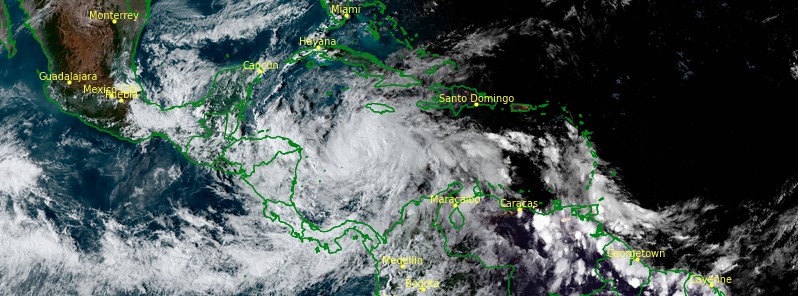
Featured image: Tropical Storm "Eta" at 21:30 UTC on November 1, 2020. Credit: NOAA/GOES-16, RAMMB/CIRA
Commenting rules and guidelines
We value the thoughts and opinions of our readers and welcome healthy discussions on our website. In order to maintain a respectful and positive community, we ask that all commenters follow these rules.