
Super Typhoon “Goni” hits Philippines as the strongest storm of the year
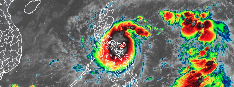
Featured image: Super Typhoon "Goni" at 21:40 UTC on October 31, 2020. Credit: JMA/Himawari-8, RAMMB/CIRA
Super Typhoon "Goni" made landfall in the Philippines over Bato, Catanduanes at 20:50 UTC (04:50 LT, November 1) and Tiwi, Albay at 23:20 UTC on October 31, 2020, with maximum sustained winds of 225 km/h (140 mph) and gusts to 280 km/h (174 mph) — which made it equivalent to a Category 5 hurricane on the Saffir Simpson Hurricane Wind Scale. This is the strongest tropical cyclone of the year and the strongest to hit the Philippines since Super Typhoon "Haiyan" killed more than 6 300 people in 2013.
- Goni, known as Rolly in the Philippines, is the 6th tropical cyclone to hit the Philippines since October 1 and one of the most powerful tropical cyclones ever recorded on Earth.
- The storm underwent rapid intensification prior to landfall; from 65 km/h (40 mph) at 12:00 UTC on October 28 to 290 km/h (180 mph) at 12:00 UTC on October 30.
- Authorities have evacuated about 1 million people before landfall.
First reports mention at least 4 casualties in the Bicol region, power outages, flash floods and widespread damage. The deaths included one person who was hit by a tree and a 5-year-old child washed away after a river overflowed.
Bicol Governor Al Francis Bichara said he also received reports of volcanic mudflows, as well as electricity supply and communication service outages.
"We are expecting major damage," said Ricardo Jalad, head of the Philippines' National Disaster Risk Reduction and Management Council (NDRRMC). "There are so many people who are really in vulnerable areas."
Super Typhoon "Goni" at 21:40 UTC on October 31, 2020. Credit: JMA/Himawari-8, RAMMB/CIRA
The capital Manila is in the projected path of the storm, with the weather bureau predicting intense rainfall and storm surges for the city.
Armed Forces of the Philippines chief-of-staff Gen. Gilbert Gapay urged all troops tapped to conduct disaster response missions to focus on their tasks.
"Today let's focus (on) the task at hand to help our countrymen particularly those situated along the path of Super Typhoon Rolly," Gapay said, adding to expect the worst as the cyclone threatens Metro Manila, Bicol Region and Central Luzon.
At 03:00 UTC on November 1 (11:00 LT), the eye of Typhoon "Goni" (Rolly) was located over the coastal waters of Pasacao, Camarines Sur; moving W at 25 km/h (15 mph).
It had maximum sustained winds of 215 km/h (130 mph) and gusts to 295 km/h (185 mph), according to PAGASA.
The agency warned that catastrophic violent winds and intense to torrential rainfall associated with the region of the eyewall and inner rainbands of the typhoon is expected within the next 12 hours over the western portion of Camarines Sur, Marinduque, the central and southern portions of Quezon, Laguna, the eastern portion of Batangas, and Cavite.
Tropical Cyclone Wind Signal (TCWS) No. 4 is up in Camarines Norte, Camarines Sur, Catanduanes, Albay, the northern portion of Sorsogon (Donsol, Pilar, Castilla, Sorsogon City, Prieto Diaz, Gubat, Barcelona, Juban, Casiguran, Magallanes), Burias Island, Marinduque, Metro Manila, Cavite, Laguna, Batangas, Rizal, Quezon including Polillo Islands, Pampanga, Bulacan, the southern portion of Aurora (Dingalan), Bataan, the southern portion of Zambales (San Marcelino, San Felipe, San Narciso, San Antonio, Castillejos, Subic, Olongapo City, Botolan, Cabangan), the northwestern portion of Occidental Mindoro (Mamburao, Paluan) including Lubang Island, and the northern portion of Oriental Mindoro (Puerto Galera, San Teodoro, Baco, Calapan City, Naujan, Pola, Victoria, Socorro, Pinamalayan).
Areas under TCWS No. 3 are rest of Sorsogon, the northern portion of Masbate (Mobo, Masbate City, Milagros, Uson, Baleno, Aroroy, Mandaon) including Ticao Island, the rest of Zambales, Romblon, the rest of Occidental Mindoro, the rest of Oriental Mindoro, Tarlac, the southern portion of Nueva Ecija (Cuyapo, Talugtug, Muñoz City, Llanera, Rizal, Bongabon, Gabaldon, General Tinio, Laur, Palayan City, General Mamerto Natividad, Cabanatuan City, Santa Rosa, Peñaranda, Gapan City, San Isidro, Cabiao, San Antonio, Jaen, San Leonardo, Zaragoza, Aliaga, Talavera, Santo Domingo, Quezon, Licab, Guimba, Nampicuan), and the central portion of Aurora (San Luis, Baler, Maria Aurora), and Northern Samar.
TCWS No. 2 is now up in the rest of Aurora, Nueva Vizcaya, Quirino, Benguet, La Union, Pangasinan, the rest of Nueva Ecija , the rest of Masbate, northern portion of Samar (Catbalogan City, Jiabong, Motiong, Paranas, Hinabangan, San Sebastian, Tarangnan, Pagsanghan, San Jorge, San Jose de Buan, Matuguinao, Gandara, Santa Margarita, Calbayog City, Santo Nino, Almagro, Tagapul-An), the northern portion of Eastern Samar (San Julian, Sulat, Taft, Can-Avid, Dolores, Maslog, Oras, San Policarpo, Arteche, Jipapad), the extreme northern portion of Antique (Pandan, Libertad, Caluya), and the northwestern portion of Aklan (Buruanga, Malay, Nabas, Ibajay).
TCWS No. 1 is in effect for Mainland Cagayan, Isabela, Apayao, Kalinga, Mountain Province, Ifugao, Abra, Ilocos Norte, Ilocos Sur, and the northern portion of Palawan (El Nido, Taytay, Dumaran, Araceli), Cuyo Islands, rest of the northern portion of Antique (Sebaste, Culasi, Tibiao, Barbaza, Laua-An), the rest of Aklan, Capiz, the northern portion of Iloilo (Lemery,Sara,Concepcion, San Dionisio, Batad, Estancia, Balasan, Carles), the northern portion of Cebu (San Remigio, Bogo City, Medellin, Daanbantayan) including Bantayan Islands, Biliran, the rest of Samar, the rest of Eastern Samar, and the northern portion of Leyte (San Isidro, Tabango, Villaba, Matag-Ob, Palompon, Ormoc City, Pastrana, Palo, Calubian, Leyte, Kananga, Capoocan, Carigara, Jaro, Tunga, Barugo, Alangalang, Santa Fe, Tacloban City, Babatngon, San Miguel).
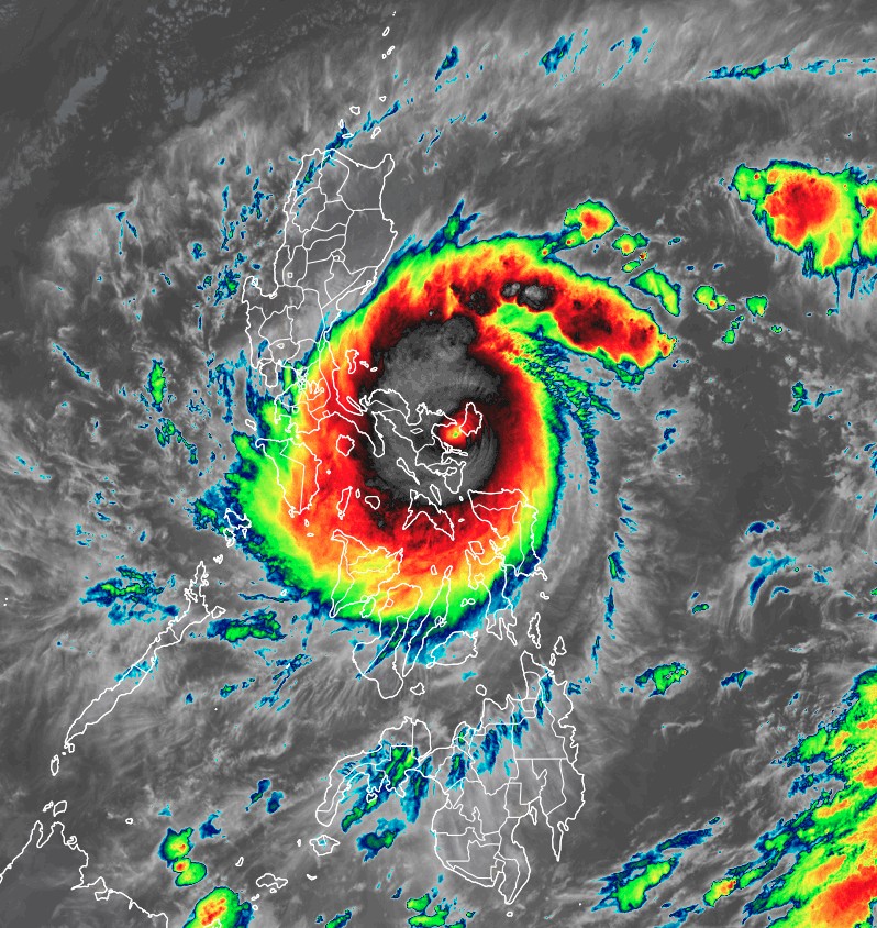
Typhoon "Goni" at 08:10 UTC on November 1, 2020. Credit: JMA/Himawari-8, RAMMB/CIRA
At 06:00 UTC on November 1, the center of Typhoon "Goni" (Rolly) was about 455 km (280 miles) east-southeast of Manila, Philippines.
The storm had maximum 10-minute sustained winds of 150 km/h (90 mph), maximum 1-minute sustained winds of 240 km/h (150 mph), and gusts up to 215 km/h (130 mph).
The minimum central barometric pressure was 965 hPa, and the system was moving west at 26 km/h (16 mph).
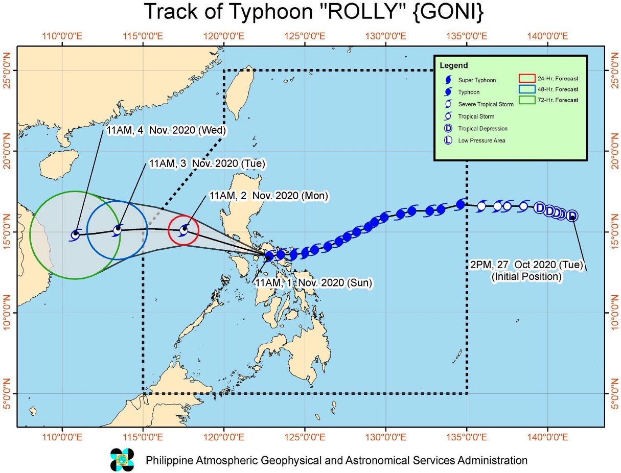
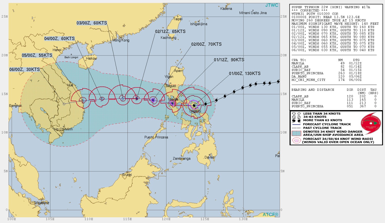
Image credit: JTWC
Goni will continue to track overland over the next 12 hours, JTWC said at 03:00 UTC on November 1.
Continued moderate vertical wind shear and the overland track will lead to continued weakening to 165 km/h (100 mph).
By 03:00 UTC on November 2, the system will have begun to track over the South China Sea. Cooler sea surface temperatures and continued moderate vertical wind shear will lead to further weakening to 130 km/h (80 mph) by this time.
The storm will track generally westward over the next 4 days and make its final landfall over central Vietnam, south of Da Nang, at around 00:00 UTC on November 5.
After landfall, Goni will rapidly weaken due to terrain effects.
Update
Monday, November 2 at 08:30 UTC
Goni made its third landfall in the vicinity of San Narciso, Quezon at 12:00 LT and fourth in the vicinity of Lobo, Batangas at 17:30 LT on November 1.
A total of 1 468 296 people were affected in Regions II, III, Calabarzon, MIMAROPA, and V, the National Disaster Reduction and Management Council noted in Sitrep No. 3 (11:00 LT, November 2).
The death toll rose to 17, the Office of Civil Defense (OCD) in Bicol said on Monday.
OCD division chief for operations said most of the fatalities were either swept away or buried by a huge volume of volcanic material that cascaded down the slopes of Mayon volcano due to heavy rain, the Philippines News Agency (PNA) reports.
An initial OCD report showed that local disaster councils evacuated 108 561 families or 394 859 people living in areas prone to flooding, lahar flow, landslide, and storm surge in the provinces of Albay, Sorsogon, Camarines Sur, Camarines Norte, and Catanduanes.
Flooding hit the towns of Camalig, Sto. Domingo, Oas, Polangui, Guinobatan, Rapu-rapu, Daraga. 30 towns reported flooding in Camarines Sur.
Lahar-carrying boulders damaged bridges in Daraga and Sto. Domingo while 147 houses were buried by lahar and mudflow in Guinobatan town, their Municipal Disaster Risk Reduction and Management Office (MDRRMO) reported.
I'm a dedicated researcher, journalist, and editor at The Watchers. With over 20 years of experience in the media industry, I specialize in hard science news, focusing on extreme weather, seismic and volcanic activity, space weather, and astronomy, including near-Earth objects and planetary defense strategies. You can reach me at teo /at/ watchers.news.
Commenting rules and guidelines
We value the thoughts and opinions of our readers and welcome healthy discussions on our website. In order to maintain a respectful and positive community, we ask that all commenters follow these rules.