
Hurricane “Delta” heads toward Louisiana, U.S. after leaving at least 9 people dead in Mexico
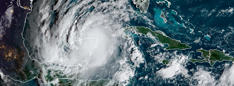
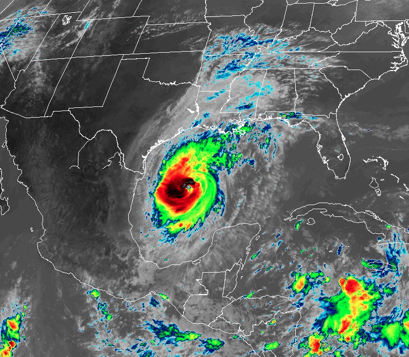
Featured image: Hurricane "Delta" at 13:10 UTC on October 7, 2020. Credit: NOAA/GOES-16, RAMMB/CIRA
Delta made landfall at 10:45 UTC on October 7, 2020, along the northeastern coast of the Yucatan Peninsula, near Puerto Morelos, as a high-end Category 2 hurricane with maximum sustained winds of 175 km/h (110 mph). The storm is now heading toward Louisiana, U.S., with landfall expected before 19:00 LT on Friday, October 9.
- Delta is expected to grow in size as it approaches the northern Gulf Coast, where life-threatening storm surge and dangerous hurricane-force winds are likely beginning Friday, particularly for portions of the Louisiana coast, NHC forecasters warned. Storm Surge and Hurricane Warnings are in effect, and residents in these areas should follow advice given by local officials and rush preparedness actions to completion.
- Flash, urban, small stream and minor to isolated moderate river flooding is likely Friday and Saturday from portions of the central Gulf Coast into portions of the Lower to Middle Mississippi Valley. As Delta moves farther inland, additional heavy rainfall is expected in the Ohio Valley and Mid Atlantic this weekend.
- Delta is forecast to be the record 10th US landfalling tropical cyclone in a single season, beating 9 landfalls in 1916.
- Areas along the Northern Gulf Coast are at risk for impacts while still dealing with the aftermath of hurricanes Laura and Sally.
The storm weakened into a Category 1 hurricane as it moved over Yucatan, damaging trees and powerlines, and causing other structural damage throughout the peninsula.
A 65-years-old man died in Tizimin before the arrival of the storm after falling from the second floor of his house during preparations. Two others were injured in separate incidents before Delta's arrival.
At least 9 people were killed in Yucatan, Tabasco, and Chiapas States after floods and landslides. Over 35 000 people have been evacuated to temporary evacuation centers in Yucatan.
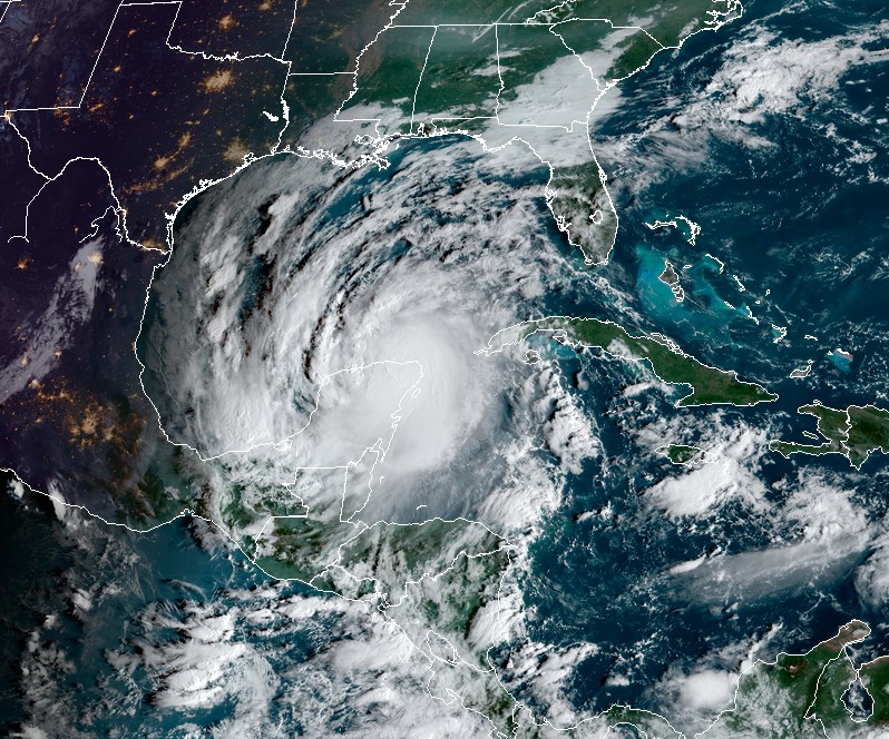
Delta strengthened back to a Category 2 hurricane by 06:00 UTC on October 8.
At the time, its center was located 780 km (485 miles) SSE of Cameron, Louisiana, U.S.
The system had maximum sustained winds of 155 km/h (100 mph) and minimum central pressure of 973 hPa.
Hurricane "Delta" at 13:10 UTC on October 7, 2020. Credit: NOAA/GOES-16, RAMMB/CIRA
On Tuesday, October 6, Louisiana Gov. John Bel Edwards declared a state of emergency, allowing the state to begin its preparations and to assist local governments as they respond.
"Hurricane Delta is an incredibly dangerous storm that will bring heavy winds, rain and life-threatening flooding and storm surge to coastal Louisiana," Edwards said.
"Everyone in South Louisiana should pay close attention to the weather in the coming days and heed the advice and directions of their local officials. Now is the time to make preparations for Delta’s impacts."
"All of Louisiana’s coast is in the tracking cone, and we are well aware that impacts can be felt outside of the track," Edwards said Tuesday.
More than a dozen Louisiana cities or parishes have issued evacuation orders or recommendations ahead of the town, including Cameron, which is still under a mandatory evacuation forced by Hurricane "Laura" ahead of its devastating landfall on August 27.
"We've actually never been lifted from the mandatory evacuation, so it’s kind of like there’s not supposed to be anybody down here," Cameron Fire Chief Tim Dupont told The Weather Channel Wednesday afternoon.
Just to give everyone an idea of the damage we haven't recovered from yet. This is an aerial shot of Lake Charles. Look at the blue tarps on all those roofs! pic.twitter.com/iNjoa8Idp1
— Lora Perkins (@doceotors) October 7, 2020
The firefighters are among the only people who've come back to Cameron, and they've been living in trailers, TWC's Jan Wesner Childs noted.
"Very, very few people have returned," Dupont said. Electricity to the town isn't expected to be restored until January, assuming Delta doesn't set that schedule back even more.
By 09:00 UTC, Beta's center was located about 725 km (450 miles) SSE of Cameron. It is expected to become a major hurricane by tonight as it moves over the central Gulf of Mexico.
A Storm Surge Warning is in effect for:
– Sabine Pass to Ocean Springs, Mississippi, including Calcasieu Lake, Vermilion Bay, Lake Pontchartrain, Lake Maurepas, and Lake Borgne.
A Storm Surge Watch is in effect for:
– High Island, TX to Sabine Pass.
– East of Ocean Springs, Mississippi to the Mississippi/Alabama border.
A Hurricane Warning is in effect for:
– East of Sabine Pass to Morgan City, Louisiana.
A Tropical Storm Warning is in effect for:
– San Luis Pass, Texas to Sabine Pass.
– East of Morgan City, Louisiana to the mouth of the Pearl River, including New Orleans.
– Lake Pontchartrain and Lake Maurepas.
A Tropical Storm Watch is in effect for:
– East of the mouth of the Pearl River to Bay St. Louis Mississippi.
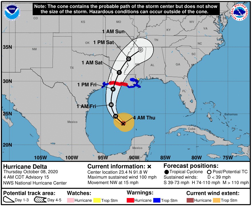
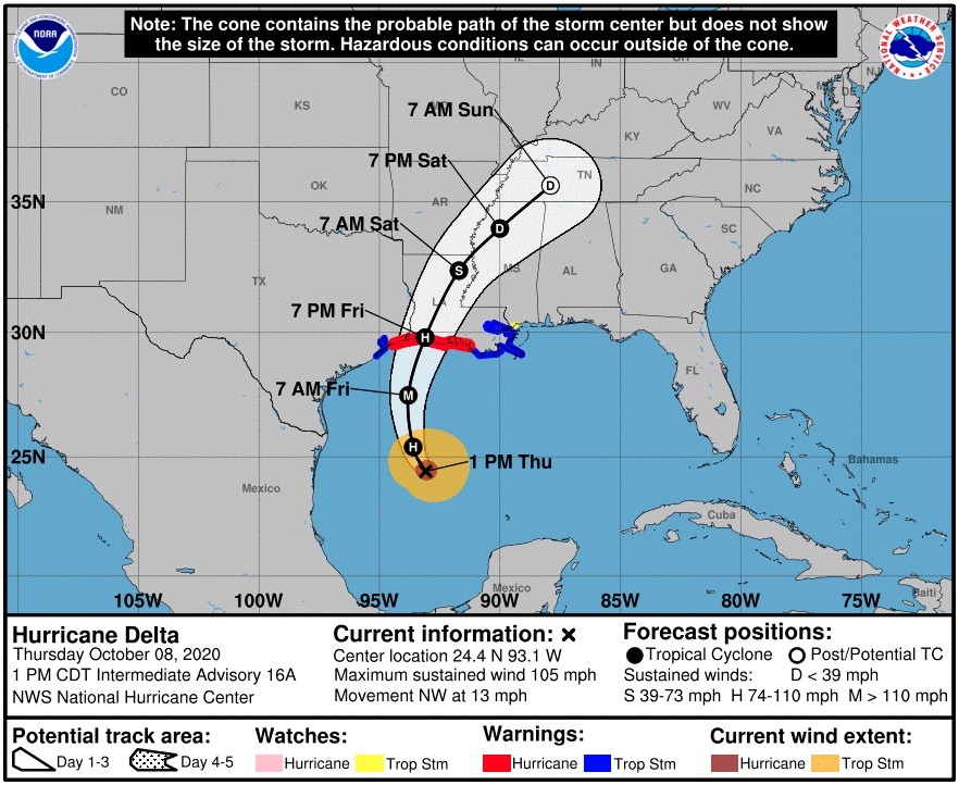
On the forecast track, the center of Delta will move inland within the hurricane warning area Friday afternoon or Friday night.
The combination of a dangerous storm surge and the tide will cause normally dry areas near the coast to be flooded by rising waters moving inland from the shoreline.
According to the NHC, the water could reach the following heights above ground somewhere in the indicated areas if the peak surge occurs at the time of high tide:
- Pecan Island to Port Fourchon, LA including Vermilion Bay: 2.1 to 3.3 m (7 – 11 feet)
- Cameron, LA to Pecan Island, LA: 1.2 to 2.1 m (4 – 7 feet)
- Port Fourchon, LA to the Mouth of the Mississippi River: 1.2 – 1.8 m (4 – 6 feet)
- Mouth of the Mississippi River to Ocean Springs, MS: 0.9 – 1.5 m (3 – 5 feet)
- Lake Borgne, Lake Pontchartrain, and Lake Maurepas: 0.9 – 1.5 m (3 – 5 feet)
- Ocean Springs, MS to MS/AL border: 0.6 – 1.2 m (2 – 4 feet)
- High Island, TX to Cameron, LA including Calcasieu Lake: 0.6 – 1.2 m (2 – 4 feet)
- MS/AL border to the AL/FL border including Mobile Bay: 0.3 – 0.9 m (1 – 3 feet)
- Sabine Lake: 0.3 – 0.9 m (1 – 3 feet)
- Port O'Connor, TX to High Island, TX including Galveston Bay: 0.3 – 0.9 m (1 – 3 feet)
The deepest water will occur along the immediate coast near and to the east of the landfall location, where the surge will be accompanied by large and dangerous waves.
Surge-related flooding depends on the relative timing of the surge and the tidal cycle, and can vary greatly over short distances.
Hurricane conditions are expected within the hurricane warning area by Friday afternoon or evening, with tropical storm conditions expected within this area earlier on Friday. Tropical storm conditions are expected within the tropical storm warning areas on Friday.
Friday through Saturday, Delta is expected to produce 125 – 250 mm (5 to 10 inches) of rain, with isolated maximum totals of 380 mm (15 inches), for southwest into south-central Louisiana. These rainfall amounts will lead to significant flash, urban, small stream flooding, along with minor to isolated moderate river flooding.
For extreme east Texas into northern Louisiana, southern Arkansas, and western Mississippi, Delta is expected to produce 75 – 150 mm (3 to 6 inches) of rain, with isolated maximum totals of 250 mm (10 inches). These rainfall amounts will lead to flash, urban, small stream, and isolated minor river flooding.
As Delta moves farther inland, 25 to 75 mm (1 to 3 inches) of rain, with locally higher amounts, is expected in the Ohio Valley and Mid Atlantic this weekend.
A few tornadoes are possible late tonight through Friday over the southern parts of Louisiana and Mississippi.
Swells from Delta will begin to affect portions of the northern and western Gulf coast later today. These swells are likely to cause life-threatening surf and rip current conditions.
Update
Delta's center was located about 595 km (370 miles) S of Cameron, Louisiana at 18:00 UTC today.
The storm had maximum sustained winds of 165 km/h (105 mph) and minimum central pressure of 966. It was moving NW at 21 km/h (13 mph).
NW motion with a reduction in forward speed is expected this afternoon (local time), followed by a turn toward the north by late tonight, and a north-northeastward motion by Friday afternoon or Friday night.
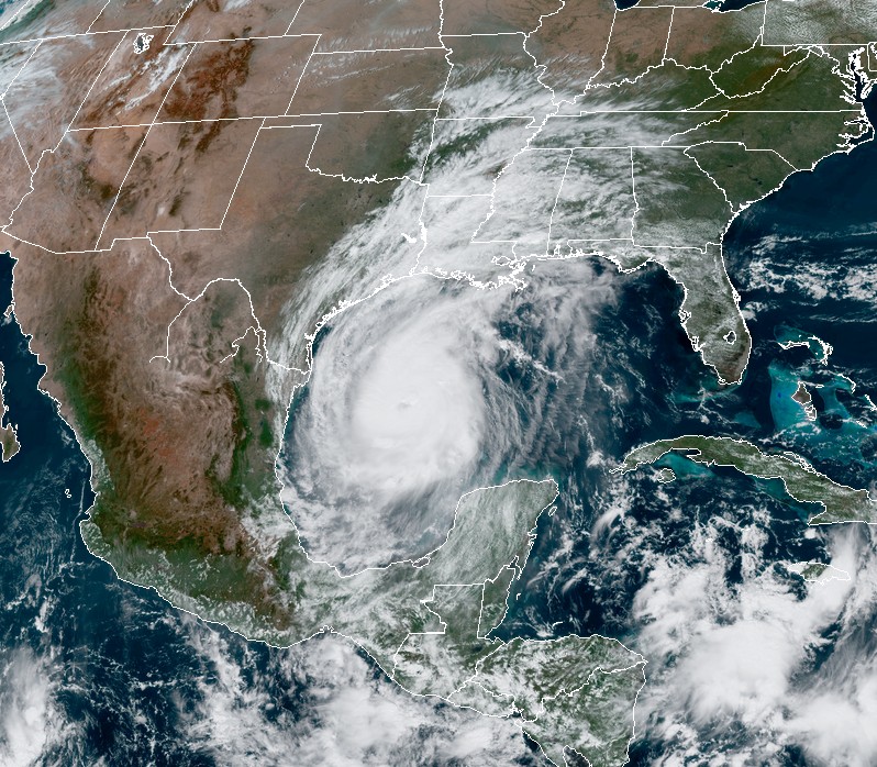
Hurricane "Delta" at 19:30 UTC on October 8, 2020. Credit: NOAA/GOES-16, RAMMB/CIRA
On the forecast track, the center of Delta will move over the western Gulf of Mexico this afternoon, over the northwestern Gulf of Mexico on Friday, and then inland within the hurricane warning area (High Island, Texas to Morgan City, Louisiana) Friday afternoon or Friday night.
I'm a dedicated researcher, journalist, and editor at The Watchers. With over 20 years of experience in the media industry, I specialize in hard science news, focusing on extreme weather, seismic and volcanic activity, space weather, and astronomy, including near-Earth objects and planetary defense strategies. You can reach me at teo /at/ watchers.news.
Commenting rules and guidelines
We value the thoughts and opinions of our readers and welcome healthy discussions on our website. In order to maintain a respectful and positive community, we ask that all commenters follow these rules.