
Days of extremely heavy rains trigger floods and landslides, affecting 30 000 in northeastern India
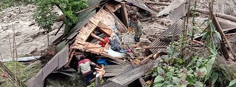
Image credit: Prakash Adhikari
Extremely heavy rains have been impacting India's northeastern states since May 20, 2020, causing flooding and landslides that killed at least one person in Sikkim and affected around 30 000 in Assam, where a severe flood situation alert has been issued by the Central Water Commission (CMC) on May 26.
In Assam, the Puthimari and Jia Bharali rivers became swollen following heavy downpour brought by the remains of Tropical Cyclone "Amphan."
The highest flood level for the Brahmaputra in the Jorhat stretch is 87.7 m (287.7 feet) and the current level is 85.8 m (281.5 feet), according to local media. In Jiabharali, the highest flood level is 78.5 m (257.5 feet) and the current level is 77.4 m (253.9 feet).
According to the Assam State Disaster Management Authority (ASDMA), a total of 128 villages in eight revenue circles of Lakhimpur Dehmaji, Dibrugarh, Darrang, and Goalpara districts were impacted, and a total of 30 701 people were affected in the state.
The worst-hit is the district of Goalpara, where 33 relief camps have been set up, accommodating almost 9 000 people.
Around 579 ha (1 430 acres) of crop areas in the districts of Lakhimpur and Dhemaji were also hit, and nearly 12 000 domestic animals and poultry have been affected.
Flooding is a yearly occurrence in Assam, usually starting at the beginning of the monsoon season. However, the current flooding came about three to four weeks earlier than normal.
On Tuesday, May 26, the CMC has issued a flood alert for the Brahmaputra river in three districts of Assam namely Jorhat, Sonitpur, and Baksa.
Near Panigaon Gram Panchayat under Lakhimpur assembly constituency has lost a lot of lands of the local people due to landslide of Sovanshiri river. Local MLA Mr. Utpal Dutta did not pay any attention to the issue. pic.twitter.com/kTzf41mn0U
— প্ৰশান্ত কৈৱৰ্ত (@Prasant65458720) May 24, 2020
নেৰানেপেৰা বৰষুণৰ ফলত ধুবুৰী চহৰৰ বিভিন্ন অঞ্চল জলমগ্ন হৈ পৰিছে ।#AssamFlood#AIRPics : Pradip pic.twitter.com/xBNNTMr8Qa
— AIR News Guwahati (@airnews_ghy) May 24, 2020
#AssamFloodCorona Sandwiched between Corona and impending major flood due to continuous torrential rain post-Cyclone Amphan, Assam is heading for very tough times. pic.twitter.com/bEEIzlhHyx
— Mrinal Talukdar (@mrinaltalukdar8) May 24, 2020
Nalbari DC Bharat Bhusan Dev Chaudhury takes the stocks of flood situation of Purni area in Nalbari district where the Buhradia river breached its embankment this morning.
# AIRPics-Ramen #Assamflood pic.twitter.com/796VxH3Wo8
— AIR News Guwahati (@airnews_ghy) May 26, 2020
Flood in Assam pic.twitter.com/2pXjuW3QxT
— Tultul Kutum's Diary (@tultulkutumm) May 26, 2020
In Sikkim, incessant rains triggered a landslide in the Upper Lingchom area on May 24, killing at least one person and leaving two others injured. According to officials, the victim lost her life while trying to escape the mudslide. Several houses sustained damages, prompting evacuations.
Heavy rainfall also disrupted the water supply lines and sources of Gangtok and nearby areas. While field engineers were able to restore it temporarily, the water had high turbidity, affecting water distribution.
According to SkyMet Weather's Mahesh Palawat, the threat will remain over Assam until May 28. "South-westerly wind blowing from the Bay of Bengal is increasing the moisture content in the area due to it there is more rainfall. The rains will, however, decrease after two days."
Two killed by #landslide at North #Sikkim @paragaditya @karishmahasnat @subhasish8508 @IndraHangSubba1 @PremDasRai pic.twitter.com/Y8Vw4kyZiT
— Prakash Adhikari (@prakash03374729) May 26, 2020
TRAGIC: One 50-yr-old Woman has been killed due to Landslide in Mangan, #Sikkim
For the past two days, it had rained continuously leading to the landslide in Upper Lingchom village under North Sikkim District. pic.twitter.com/WBuxTK2siQ
— The Darjeeling Chronicle (@TheDarjChron) May 24, 2020
Commenting rules and guidelines
We value the thoughts and opinions of our readers and welcome healthy discussions on our website. In order to maintain a respectful and positive community, we ask that all commenters follow these rules.