
Powerful Kona Low continues to drench Hawaii, flash flood watches in force for all islands with rare tornado warning for Niihau
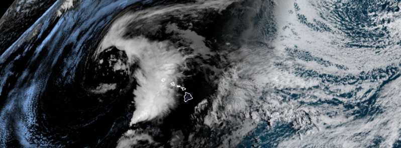
Image credit: NOAA/GOES-West, RAMMB/CIRA. Acquired March 17, 2020, at 16:50 UTC.
The National Weather Service (NWS) has placed all islands of Hawaii under flash flood watch on Tuesday, March 17, 2020– and issued a rare tornado warning for Niihau for the first time in 11 years– as a powerful low-pressure system – Kona Low – continues to dump widespread heavy rains across the islands.
The low is forecast to further produce bands of thunderstorms into Wednesday, March 18, with east-southeast winds of about 24 to 27 km/h (15 to 17 mph), and gusts as high as 37 km/h (23 mph). Scattered to isolated showers are also forecast to persist until Monday next week, March 23.
All islands, namely Kahoolawe, Kauai, Lanai, Maui, Molokai, Niihau, Oahu, and the Big Island, could be impacted by flash flooding due to heavy rainfall, with Kuau and Oahu expected to be at the greatest risk.
"A Kona low west of the state will continue to produce bands of heavy rain and thunderstorms across portions of the island chain through tonight, and possibly into Wednesday," said NSW on Tuesday.
"While all islands could experience flooding rainfall, the greatest risk for flooding will be on Kauai and Oahu, where soils are already saturated due to recent heavy rain."
Moreover, inundations also threaten urban and leeward locations, particularly areas on lower elevations, NWS added.
The agency also emphasized that flash floods are life-threatening, with a warning saying, "do not cross fast-flowing water in your vehicle or on foot."
"Monitor later forecasts and be prepared to take action if a Flash Flood Warning is issued. If you experience heavy rain or rising water, head to higher ground immediately," NWS further warned.
A rare tornado warning was also issued for the island of Niihau on Tuesday, which may be extended, dropped, or modified as conditions vary. Local reports warn of flying debris, as well as damage to roofs, windows, and vehicles.
"This tornadic thunderstorm will remain over sparsely populated areas of Niihau in Kauai county," said Khon2 News. This warning has been the first for Hawaii in more than 11 years.
Just to add to the list of oddities in the world right now…
The NWS office in Honolulu, Hawaii issued a tornado warning today. It's their first in more than 4,100 days…that's more than 11 years! #hiwx pic.twitter.com/siudOJ2KLx
— Weather World (@WeatherWorldPSU) March 17, 2020
Tornado warning for the island of Niihau. Going to come in near Kalaoa Beach. Last tornado warning was 2008 per @gdimeweather pic.twitter.com/SaWo95RkHj
— Jim Cantore (@JimCantore) March 17, 2020
BREAKING: Possible #tornado moving onshore in #Hawaii between Port Allen and Kauamakani on the island of Kauai. This is extremely unusual.
The last time the National Weather Service in Honolulu issued a tornado warning was on December 13, 2008. They've issued 2 this morning. pic.twitter.com/4WOYPyQSF0
— Matthew Cappucci (@MatthewCappucci) March 17, 2020
According to NWS's forecast, there will be occasional showers and possibly a thunderstorm on Wednesday. Furthermore, some of the storms could generate heavy downpour.
Breezy winds are expected, with an east-southeast winds 24 to 27 km/h (15 to 17 mph) gusting to 37 km/h (23 mph). New rainfall amounts between 25 to 51 mm (1 to 2 inches) are also likely.
Scattered showers and thunderstorms will continue until Friday, March 20, with up to 70 percent chance of precipitation.
By Saturday, March 21, scattered showers will occur but it will be mostly cloudy. On Monday, March 23, NWS forecast isolated showers; it will also be most likely sunny with a 20 percent chance of rain.
LEARNING AT HOME- "Kona" low pressure forecast to bring heavy rains, storms & high winds across the Hawaiian Islands thru midweek. These lows form in winter & they typically experience 2-3 annually. Kona refers to "Kona Coast" (west side) of Hawaii. @wsvn pic.twitter.com/YG0JLw625Y
— Vivian Gonzalez (@VivianGonzalez7) March 17, 2020
Well Aloha. Check out the tropical moisture wrapping around a large Kona Low west of #Hawaii today. #HIwx https://t.co/LA5VIMeogY pic.twitter.com/Fk7gi6h668
— UW-Madison CIMSS (@UWCIMSS) March 17, 2020
2/14/20
The time is suddenly apon us all
2/23/20 is the planting of the corn.