
Icy roads impact travel ahead of major multi-hazard storm, snow, and damaging winds across central U.S.
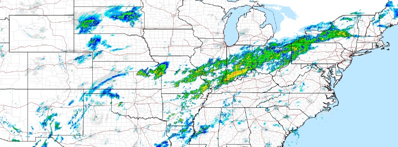
Image credit: NWS
A large multi-hazard storm is forecast to pound the central US, particularly the Plains and Midwest starting Friday, January 10, 2020. The storm will shift to the East Coast by early Sunday, January 12. Heavy snow and ice may lead to dangerous travel conditions from the Plains to New England. However, extremely dangerous traffic on icy roads was already reported in Wisconsin on Thursday morning, January 9.
Light rain falling on frozen roads made extremely dangerous driving conditions in Wisconsin, prompting authorities to close an interstate. The Wisconsin Department of Transportation advised residents to avoid travel from Tomah to La Crosse.
The department's 511 map showed many highways were covered in ice, including Hwy 29 from Abbotsford to Wittenberg, Hwy 10 from Auburndale to Weyauwega, Hwy 13 from Abbotsford to Wisconsin Dells, Hwy 21 from Necedah to Wautoma, Hwy 45 from Antigo to Oshkosh and I-39/51 from Merrill to Portage.
"If you do not have to drive, please stay off the roads," the La Crosse police also warned.
According to the police, there were "reports of multiple traffic lights struck and knocked down in the city." Furthermore, several accidents were reported in Sheridan.
11 states from Texas to Michigan are on alert for probable flash flooding ahead of a major storm on course to hit the Plains and Midwest on Friday.
Tornadoes, damaging winds, and hailstorm are likely in Dallas, Houston, Little Rock, and Shreveport from Friday night into early Saturday, January 11.
Heavy rain may spark flash flooding from Texas to Missouri to Michigan, including Dallas, St. Louis, Indianapolis, and Detroit.
Icy conditions will develop on the backside of the storm from Wichita to Kansas to Chicago.
"A wintry mix of snow, sleet, and freezing rain is possible in portions of the Southern/Central Plains into the Middle Mississippi Valley and northeastward into the Great Lakes region Friday into Saturday after the cold front drops the temperatures," NWS stated.
Tornado risks will persist through Saturday, as well as damaging winds and hailstorm in Mississippi, Alabama, western Georgia, and Tennessee. New Orleans, Birmingham, and Jackson are also at risk.
76 to 127 mm (3 to 5 inches) of rain are forecast for the Mississippi, Tennessee, and Ohio Valleys through Saturday night. Up to 30 cm (12 inches) of snow is likely in the Great Lakes and Michigan.
By Sunday, January 12, most of the snow and severe weather will have subsided. However, icy conditions will continue across parts of northern New England. NWS warned that travel may be dangerous from the Plains to New England. Heavy downpour is likely for the Northeast.
"On Sunday, the rain will push to the Atlantic coast from northern Florida to Maine, but for much of this swath, the rain will be in the diminishing stages compared to that of the Mississippi Valley," AccuWeather reported.
Commenting rules and guidelines
We value the thoughts and opinions of our readers and welcome healthy discussions on our website. In order to maintain a respectful and positive community, we ask that all commenters follow these rules.