
Slow-moving storm to drop heavy rain on parts of Louisiana and Texas, USA
Featured image: 10-day rainfall accumulation ECMWF model run September 17 (through September 27). Credit: Windy
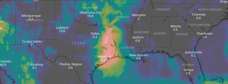
While Hurricane "Humberto" continues to move further away from the southeastern U.S. and toward the Bermuda, heavy showers and thunderstorms associated with a broad area of low pressure are moving onshore into the western Gulf coast. NWS said its forecast calls for 180+ mm (7+ inches) of rain across eastern Texas for the next few days. Meanwhile, rip currents/heavy surf are likely to continue from Florida to the Carolinas from Humberto.
The main area of precipitation concern will be across southeastern Texas as a very slow-moving disturbance from the western Gulf of Mexico ushers in copious moisture to this region.
A Moderate Risk of excessive rainfall from the Weather Prediction Center exists for the elevated potential of flash flooding from several inches of expected rainfall.
A northward-moving tropical disturbance will cause heavy rainfall in southeast TX & southwest LA. An area of 2-4" of rain, with local amounts of 6-9", is expected from Tuesday a.m. through Wednesday a.m. A moderate risk of excessive rainfall exists for Houston & Galveston. pic.twitter.com/4iVZsHRgFR
— NWS WPC (@NWSWPC) September 17, 2019
Elsewhere, moderate to locally heavy rain is likely from northern California to western Washington as a new Pacific storm system progresses inland, with some rainfall totals up to 50 mm (2 inches) possible.
Across the Upper Midwest, a swath of showers and thunderstorms will be possible ahead of a frontal boundary.
The overall weather pattern across the continental U.S. will be rather amplified aloft through the middle of the week with an upper level ridge encompassing much of the central U.S., and troughs near both the East and West Coasts, NWS forecaster Hamrick noted 07:54 UTC today.
The ridge is expected to result in temperatures on the order of 5.5 – 11 °C (10 to 20 °F) above average from the central Plains to the Upper Midwest for Tuesday and Wednesday, September 17 and 18.
An upper level trough building in across the Pacific Northwest and Intermountain West should keep below average temperatures in place, with perhaps some snow for the highest mountains.
For the Mid-Atlantic and Northeast, a high quality airmass will become established over the region as a strong surface high from Canada governs the overall weather, making it feel more like autumn compared to recent days.
I'm a dedicated researcher, journalist, and editor at The Watchers. With over 20 years of experience in the media industry, I specialize in hard science news, focusing on extreme weather, seismic and volcanic activity, space weather, and astronomy, including near-Earth objects and planetary defense strategies. You can reach me at teo /at/ watchers.news.
Commenting rules and guidelines
We value the thoughts and opinions of our readers and welcome healthy discussions on our website. In order to maintain a respectful and positive community, we ask that all commenters follow these rules.