Eruption at Asamayama volcano, alert level raised to 3 of 5, Japan
The Japan Meteorological Agency (JMA) has raised the volcanic alert level for Asamayama volcano from 2 to 3 of 5 following an eruption at 13:08 UTC (22:08 JST) on August 7, 2019. The volcano is located about 140 km (87 miles) NW of capital Tokyo. This volcano has had several major plinian eruptions, the last two of which occurred in 1108 (VEI 5) and 1783 (VEI 4). Its last eruption took place in 2015 (VEI 1).
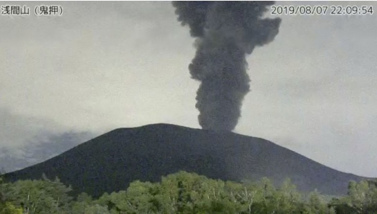
Ash is rising 4 300 m (14 100 feet) above sea level, about 1 800 m (5 900 feet) above the crater.
Local authorities said there were no immediate reports of injuries.
JMA said it expects more eruptions, capable of affecting nearby communities. Pyroclastic flows are possible within 4 km (2.5 miles) of the crater, it said, urging residents and tourists not to approach the volcano.

Image credit: JMA
JMA said that activity at the volcano had been progressively increasing during the first half of June 2019. From June 2 – 5, a plume rose less than 400 m (1 300 feet) above the active crater. Weak incandescence from the summit crater was recorded at night with a webcam. Sulfur dioxide flux was a little higher than 900 tons per day when measured on June 2.
Plumes were rising as high as 300 m (984 feet) above Asamayama’s summit crater from June 16 – 23, JMA said, adding that weak crater incandescence was visible for the first time since December 23, 2017.
Geologic summary
Asamayama, Honshu's most active volcano, overlooks the resort town of Karuizawa, 140 km (87 miles) NW of Tokyo. The volcano is located at the junction of the Izu-Marianas and NE Japan volcanic arcs. The modern Maekake cone forms the summit and is situated east of the horseshoe-shaped remnant of an older andesitic volcano, Kurofuyama, which was destroyed by a late-Pleistocene landslide about 20 000 years before present (BP).
Growth of a dacitic shield volcano was accompanied by pumiceous pyroclastic flows, the largest of which occurred about 14 000 – 11 000 BP, and by growth of the Ko-Asama-yama lava dome on the east flank. Maekake, capped by the Kamayama pyroclastic cone that forms the present summit, is probably only a few thousand years old and has an historical record dating back at least to the 11th century CE.
Maekake has had several major plinian eruptions, the last two of which occurred in 1108 (Asamayama's largest Holocene eruption) and 1783 CE. (GVP)
Featured image: Asamayama erupting on August 7, 2019. Credit: JMA
Commenting rules and guidelines
We value the thoughts and opinions of our readers and welcome healthy discussions on our website. In order to maintain a respectful and positive community, we ask that all commenters follow these rules:
We reserve the right to remove any comments that violate these rules. By commenting on our website, you agree to abide by these guidelines. Thank you for helping to create a positive and welcoming environment for all.