
Tropical Cyclone “Danas” (Falcon) affecting the Philippines, heading toward Taiwan, China and the Korean Peninsula
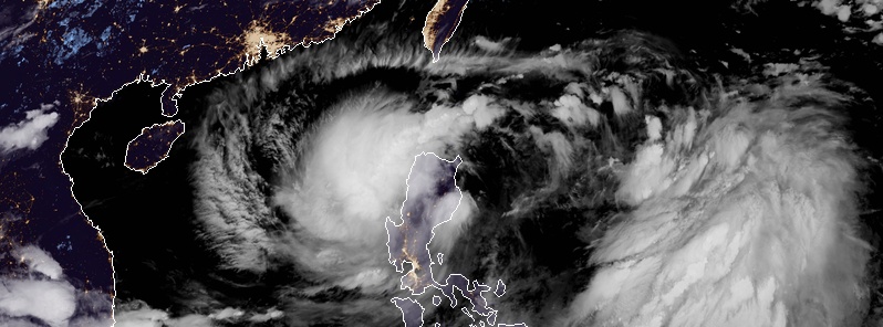
Featured image: Tropical Storm "Danas" (Falcon) at 16:30 UTC on July 16, 2019. Credit: JMA/Himawari-8, CIRA/RAMM
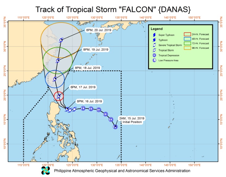
A strengthening tropical cyclone named Danas by the JMA and Falcon by the PAGASA is dumping moderate to heavy rains over parts of northern Philippines on July 16, 2019. The cyclone is expected to closely approach or make landfall over Babuyan, Philippines and then possibly over the eastern coast of Taiwan as it moves towards China and the Korean Peninsula.
An area of low pressure formed near the Mariana Islands on July 12 and continued slowly drifting westward while gradually organizing. Early on July 14, it organized into a tropical depression to the southwest of the Mariana Islands. Later that day, the tropical depression entered the Philippine area of responsibility, and the PAGASA gave the system the name Falcon.
The system continued organizing while approaching Luzon and strengthened into a tropical storm on July 16 – JMA named it Danas. As of 15:00 UTC on July 16, JTWC still categorized it as a tropical depression.
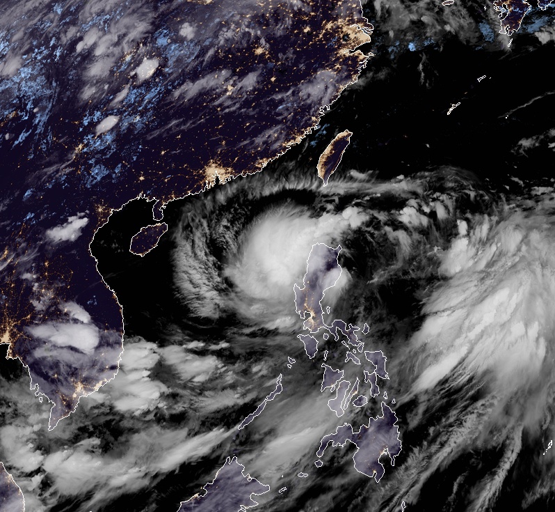
Tropical Storm "Danas" (Falcon) at 16:30 UTC on July 16, 2019. Credit: JMA/Himawari-8, CIRA/RAMMB
At 06:00 UTC on July 16, Tropical Storm "Danas" (Falcon) was about 1 085 km (675 miles) south-southwest of Kadena Air Base, Okinawa. Its maximum 10-minute sustained winds were 65 km/h (40 mph), 1-minute sustained winds 45 km/h (30 mph), with gusts up to 95 km/h (60 mph). The minimum central barometric pressure was 994 hPa, and the system was moving westward at 15 km/h (10 mph).
According to a Severe Weather Bulletin #8 issued by the PAGASA at 14:00 UTC (22:00 PHT) on July 16, Danas/Falcon has maintained its strength as it continued moving closer towards northern Luzon.
Between today and tomorrow evening, moderate to heavy rains will be experienced over Ilocos Region, Cordillera Administrative Region, Cagayan Valley, Nueva Ecija, Aurora, Zambales, Occidental Mindoro, northern Palawan including Calamian and Cuyo Islands, Aklan, Antique, Capiz, Iloilo, and Guimaras, PAGASA said in the bulletin. Meanwhile, light to moderate with at times heavy rains will be experienced over Metro Manila, CALABARZON, Bicol Region, and the rest of Visayas, Central Luzon, and MIMAROPA.
Between tomorrow evening and Thursday (July 18) evening local time, moderate to heavy rains may prevail over Ilocos Region, Cordillera Administrative Region, and Cagayan Valley. Meanwhile, light to moderate with at times heavy rains may prevail over the Metro Manila, Central Luzon, CALABARZON, and MIMAROPA.
Residents in the aforementioned areas, especially those living in areas identified to be at risk of flooding and landslides, are advised to take precautionary measures, coordinate with local disaster risk reduction and management offices, and continue monitoring for updates, especially the Thunderstorm Advisories and Heavy Rainfall Warnings to be issued by PAGASA Regional Services Divisions.
Sea travel is risky over the seaboards of areas under TCWS, the eastern seaboard of Central Luzon, the seaboard of Southern Luzon, and the eastern and western seaboards of Visayas.
This weather disturbance is expected to closely approach or make landfall over Babuyan, PAGASA said.
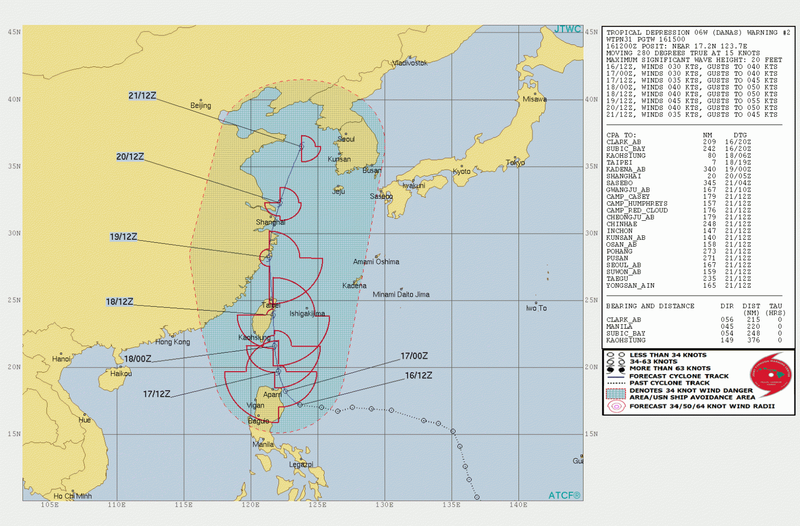
As of 14:00 UTC, the center of Danas/Falcon was located about 195 km (121 miles) ESE of Tuguegarao City, Cagayan. It was moving west at 25 km/h (15 mph) with maximum sustained winds of 65 km/h (40 mph) and gusts to 80 km/h (50 mph).
TCWS no.1 and 2 are in effect in parts of Luzon, Visayas and Mindanao.
Current forecast tracks take Danas over Babuyan, the Philippines on July 16/17 and into eastern/northern Taiwan on July 16.
I'm a dedicated researcher, journalist, and editor at The Watchers. With over 20 years of experience in the media industry, I specialize in hard science news, focusing on extreme weather, seismic and volcanic activity, space weather, and astronomy, including near-Earth objects and planetary defense strategies. You can reach me at teo /at/ watchers.news.
Commenting rules and guidelines
We value the thoughts and opinions of our readers and welcome healthy discussions on our website. In order to maintain a respectful and positive community, we ask that all commenters follow these rules.