
Tropical Cyclone “Doksuri” (Egay) intensifies near the Philippines, forecast track takes it toward Taiwan and mainland China
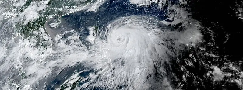
Featured image: Tropical Cyclone "Doksuri" at 08:20 UTC on July 23, 2023. Credit: JMA/Himawari-9, RAMMB/CIRA, The Watchers
Tropical Cyclone “Doksuri” — known as Egay in the Philippines — formed on July 21, 2023, as the 5th named storm of the 2023 Pacific typhoon season. The storm is currently located east of the Philippines, heading WNW toward Taiwan while intensifying. Landfall in Taiwan is expected on July 27 and in China on July 28 (UTC).
At 09:00 UTC on July 23, Severe Tropical Storm “Doksuri” was located about 1 335 km (830 miles) SSE of Taipei, Taiwan.
Its maximum 10-minute sustained winds were 100 km/h (65 mph), with gusts up to 150 km/h (90 mph), while maximum 1-minute sustained winds were at 120 km/h (75 mph).
The minimum central barometric pressure was 985 hPa, and the system was moving west-northwest at 11 km/h (7 mph), toward Taiwan.
While Doksuri is not expected to make landfall in the Philippines, the system intensified Southwest Monsoon, which may bring significant amounts of rain over the next three days, the Philippine Atmospheric, Geophysical and Astronomical Services Administration (PAGASA) said on July 23.
As a result, flooding and rain-induced landslides are possible, especially in areas that are highly susceptible to these hazards as identified in hazard maps, and in localities that experienced a considerable amount of rainfall for the past several days.
In a bulletin issued at 09:00 UTC today, PAGASA warned that areas in Catanduanes may receive between 50 and 200 mm (2 – 8 inches) of rainfall. On Tuesday, July 25, more than 200 mm (8 inches) are possible in Batanes, Babuyan Islands, northeastern portion of mainland Cagayan, and the northern portion of Ilocos Norte; between 100 and 200 mm (4 – 8 inches) in Apayao, Abra, the rest of Ilocos Norte, Ilocos Sur, La Union, and the rest of Cagayan; and between 50 and 100 mm (2 – 4 inches) in Pangasinan, Isabela, and the rest of Cordillera Administrative Region.
Doksuri and the enhanced Southwest Monsoon may also bring gusty conditions over the following areas, especially in coastal and upland/mountainous areas exposed to winds:
- Today: MIMAROPA, Visayas, and the northern portions of Zamboanga Peninsula, Northern Mindanao, and Caraga.
- Tomorrow: CALABARZON, MIMAROPA, Visayas, Zamboanga Peninsula, and the northern portions of Northern Mindanao and Caraga.
- Tuesday: Most of Luzon and Visayas, the northern portions of Zamboanga Peninsula, and Dinagat islands
In the next 24 hours, the system may also bring rough seas (2.8 to 3.5 m / 9 – 11.5 feet) over the coastal waters along the eastern seaboards of Luzon, Visayas, and Mindanao that are outside the Gale Warning area. Mariners of small seacrafts are advised to take precautionary measures when venturing over these waters. If inexperienced or operating ill-equipped vessels, avoid navigating in these conditions, PAGASA said.
Doksuri (Egay) is forecast to track west-northwestward or westward in the next 12 hours. Afterward, it will turn generally northwestward for the remainder of the forecast period.
Although the latest track forecast shows that the system will remain offshore for most of the forecast period, a close approach or landfall in the vicinity of Extreme Northern Luzon is still not ruled out based on the forecast confidence cone. On the track forecast, Doksuri will be closest to Extreme Northern Luzon on Wednesday, July 26, and make landfall over the east coast of Taiwan on Thursday morning (LT), July 28.
Based on the current and forecast behavior of the ridge of high pressure to the north of the system, a “westward shift” in the track forecast remains a possibility.
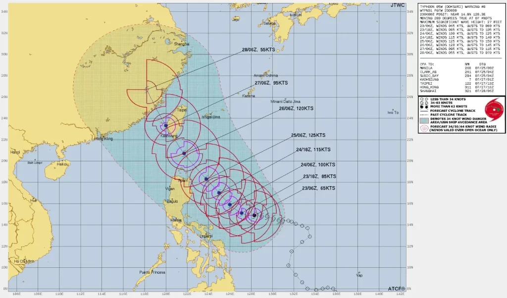
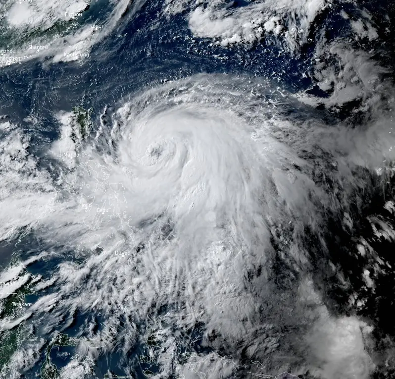
Doksuri is forecast to reach the typhoon category within 24 hours and may become a super typhoon on Tuesday, July 25.
Rapid intensification is likely within the next 72 hours due to favorable atmospheric and oceanic conditions.
A slight weakening trend may begin on Wednesday and will continue until the system makes landfall over Taiwan. Interaction with the mountainous terrain of Taiwan will result in further weakening – a trend which will continue until the tropical cyclone makes another landfall on mainland China.
References:
1 Tropical Cyclone Bulletin #10 for Severe Tropical Storm “Egay” – PAGASA – Issued at 05:00 pm, 23 July 2023
2 Weather Advisory No.2 – PAGASA – July 23, 2023
I'm a dedicated researcher, journalist, and editor at The Watchers. With over 20 years of experience in the media industry, I specialize in hard science news, focusing on extreme weather, seismic and volcanic activity, space weather, and astronomy, including near-Earth objects and planetary defense strategies. You can reach me at teo /at/ watchers.news.
Commenting rules and guidelines
We value the thoughts and opinions of our readers and welcome healthy discussions on our website. In order to maintain a respectful and positive community, we ask that all commenters follow these rules.