
Volcanic activity intensifies at Mount Merapi, Indonesia
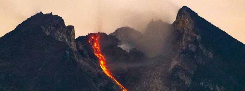
Featured image: Mount Merapi lava flow on January 14, 2019. Credit: Øystein Lund Andersen, oysteinlundandersen.com (used with permission)
Indonesian authorities are reporting increased activity at Mount Merapi over the past couple of days. Lava has so far flowed up to 800 m (2 624 feet) down the slope of the volcano. Authorities are preparing evacuation routes and emergency shelters as well as calculating logistical needs in anticipation of a major eruption. The Alert Level remains at 2 (of 4).
Apart from incandescent lava, the volcano was emitting booming sounds resembling thunder more frequently, prompting local residents to also increase the frequency of their independently organized patrols, The Jakarta Post reports.
"The volume and the extent of the lava flow were both relatively normal, but the volunteer team has banned all human activity within a 3 km (1.8 miles) from the crater," JP quoted Dimas Joko, a volunteer monitoring the volcano.
"The people are still calm because the lava so far has flowed only 500 m to 800 m (1 640 – 2 624 feet) down the slope. But we remain alert, in case Merapi erupts suddenly," he said January 16.
PVMBG advised people to stay away from the upper slopes of the mountain for their own safety, especially considering the lava flow.
Authorities are preparing evacuation routes and emergency shelters as well as calculating logistical needs in anticipation of a major eruption (masks, community kitchens, emergency tents and rehabilitation posts).
Berikut kami sampaikan Laporan Aktivitas Gunung #Merapi periode pengamatan 15 Januari 2019. #statuswaspada pic.twitter.com/5WzHNtSLhD
— BPPTKG (@BPPTKG) January 16, 2019
Incandescent material from the growing lava dome of #Merapi volcano (Central-Java) earlier this morning – 14th January. Photo taken from outside the 3km exclusion zone. pic.twitter.com/l0yJ1I5EEL
— Øystein Lund Andersen (@OysteinLAnderse) January 14, 2019
Added more photos on my website from my recent trip to observe the ongoing activity at #Merapi volcano 12-14th January. Note all photos taken from outside the 3km restriction zone. https://t.co/JtMbor5anP pic.twitter.com/WPy1V1VUsj
— Øystein Lund Andersen (@OysteinLAnderse) January 16, 2019
#Merapi volcano crater area comparison – June 2018 vs November 2018 vs Today. Photos taken from outside the 3km restriction zone. For official information on Merapi follow @BPPTKG @TRCBPBDDIY @vulkanologi_mbg pic.twitter.com/WOj7sBE5Fo
— Øystein Lund Andersen (@OysteinLAnderse) January 13, 2019
I've watched #Merapi on the BPPTKG webcams page; within ~20 min. (at least) 2 explosions occurred, followed by avalanches of hot dome material. High time to get out of the way for a few km below! Screenshot from: https://t.co/SC5AN7reSa pic.twitter.com/zE1p8VacCh
— VolcanoHotspot (@volcanohotspot) January 13, 2019
After the rain, comes good weather and clarity. And #Merapi too if you happen to be in #Yogyakarta #volcano pic.twitter.com/gzeEAPUXby
— Øystein Lund Andersen (@OysteinLAnderse) January 13, 2019
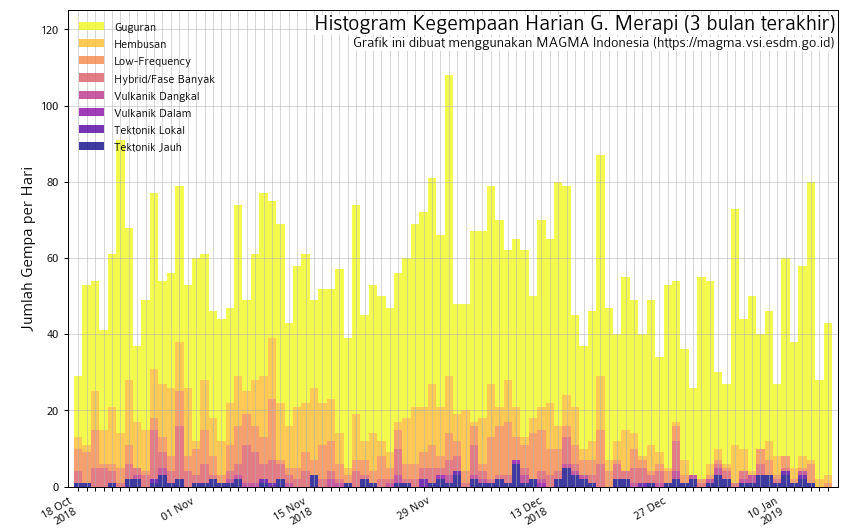
PVMBG reported that during November 30 – December 6, 2018 the lava dome in Merapi’s summit crater grew at a rate of 2 200 m3 (77 700 ft3) per day. By December 6, the volume of the dome, based on photos taken from the SE, was an estimated 344 000 m3 (12.1 million ft3). White emissions of variable density rose a maximum of 150 m (490 feet) above the summit.
The Alert Level remains at 2 (on a scale of 1-4), and residents were warned to remain outside of the 3-km exclusion zone.
Thousands of people are living on the flanks of Mount Merapi, active stratovolcano regularly erupting since 1948. It is located about 28 km (17 miles) north of Yogyakarta city (population 2.4 million).
At least 353 people were killed and more than 350 000 other displaced after the volcano erupted in 2010 (VEI 4).
In November 1994, a large explosion at the volcano produced pyroclastic flows that killed 27 people.
Geological summary
Merapi, one of Indonesia's most active volcanoes, lies in one of the world's most densely populated areas and dominates the landscape immediately north of the major city of Yogyakarta. It is the youngest and southernmost of a volcanic chain extending NNW to Ungaran volcano.
Growth of Old Merapi during the Pleistocene ended with major edifice collapse perhaps about 2 000 years ago, leaving a large arcuate scarp cutting the eroded older Batulawang volcano.
Subsequently, the growth of the steep-sided Young Merapi edifice, its upper part unvegetated due to frequent eruptive activity, began SW of the earlier collapse scarp. Pyroclastic flows and lahars accompanying growth and collapse of the steep-sided active summit lava dome have devastated cultivated lands on the western-to-southern flanks and caused many fatalities during historical time.
I'm a dedicated researcher, journalist, and editor at The Watchers. With over 20 years of experience in the media industry, I specialize in hard science news, focusing on extreme weather, seismic and volcanic activity, space weather, and astronomy, including near-Earth objects and planetary defense strategies. You can reach me at teo /at/ watchers.news.
With a rumble so low as to be inaudible, growing,
throbbing, then fuming into a thundering roar, the
earthquake starts.Only it’s not like any earthquake
in recorded history.
In California the mountains shake like ferns in a
breeze; the mighty Pacific rears back and piles up into
a mountain of water more than two miles high, then
starts its race eastward.
With the force of a thousand armies the wind
attacks, ripping, shredding everything in its supersonic
bombardment. The unbelievable mountain of Pacific sea¬
water follows the wind eastward, burying Los Angeles
and San Francisco as if they were but grains of sand.
Nothing – but nothing – stops the relentless, over¬
whelming onslaught of wind and ocean.
Across the continent the thousand mile-per-hour
wind wreaks its unholy vengeance, everywhere, merci¬
lessly, unceasingly. Every living thing is ripped into
shreds while being blown across the countryside; and the
earthquake leaves no place untouched. In many places
the earth’s molten sub-layer breaks through and spreads
a sea of white-hot liquid fire to add to the holocaust.
Within three hours the fantastic wall of water moves
across the continent, burying the wind-ravaged land
under two miles of seething water coast-to-coast. In a
fraction of a day all vestiges of civilization are gone, and
the great cities – Los Angeles, San Francisco, Chicago,
Dallas, New York – are nothing but legends. Barely a
stone is left where millions walked just a few hours
before.
A few lucky ones who manage to find shelter from
the screaming wind on the lee side of Pike’s Peak watch
the sea of molten fire break through the quaking valleys
below. The raging waters follow, piling higher and
higher, steaming over the molten earth-fire, and rising
lmost to their feet. Only great mountains such as this
one can withstand the cataclysmic onslaught.
North America is not alone in her death throes.
Central America suffers the same cannonade – wind,
earth-fire, and inundation.
South America finds the Andes not high enough
to stop the cataclysmic violence pounded out by nature
in her berserk rage. In less than a day, Ecuador, Peru, and
western Brazil are shaken madly by the devastating
earthquake, burned by molten earth-fire, buried under
cubic miles of torrential Pacific seas, and then turned
into a frozen hell. Everything freezes. Man, beast, plant,
and mud are all rock-hard in less than four hours.
Europe cannot escape the onslaught. The raging
Atlantic piles higher and higher upon itself, following
the screeching wind eastward. The Alps, Pyrennes,
Urals, and Scandinavian mountains are shaken and
heaved even higher before the wall of water strikes.
Why was this story CLASSIFIED by the CIA…?
What was SCRUBBED from the original….?
The TIMELINE…?
The Historic Evidence…?
The link to this story…—-> https://archive.org/stream/ChanThomasTheAdamAndEveStory/Chan%20Thomas%20-%20The%20Adam%20and%20Eve%20Story_djvu.txt
The answers can all be found here…—–> https://biblehub.com/kjv/1_corinthians/15.htm
Strange Sounds….Strange Clouds….
Earthquakes…..Volcanic Eruptions….
Weather gone mad….
Skies that are PURPLE….Pink…Red…..
Flashing Purple and Red and night….
Strange Orbs being seen in every country….
All have one common answer….
PLASMA from the SUN….
Rapid Crustal Displacement….
This is not the end….
This is the BEGINNING of the END….
Jesus Christ /// Yeshua Hamashiach is the LIGHT….The Truth….The only Way….
Strap yourselves in….What is coming will be worse than your wildest imaginations….
Hellywood has been predictive programming what is coming for YEARS….
Watch the movie 2012….That is coming….But way, way, way worse….
Take the movie 2012 add in The Day After Tomorrow add in Deep Impact + Dante’s Peak + Super Volcano and I could just keep going….There are HUNDREDS of them….
And they cannot even begin to show you what is coming….
Everything we are seeing is from Plasma coming from our sun…
Including the rapid movement of magnetic poles….
GOD cleansed the Earth with Water in the Days of Noah…
This time HE will do it with FIRE….