
Powerful winter storm leaves 9 people dead, thousands stranded on roads, U.S.
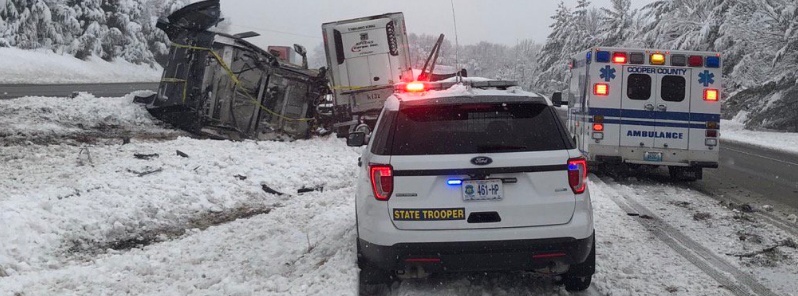
Image credit: MSHP General HQ
A powerful winter storm, named Gia by The Weather Channel, pummeled parts of the Midwest on January 11 and 12, 2019, causing hundreds of road accidents, claiming lives of at least 9 people and leaving thousands stranded on roads. Gia will continue shifting east off the Carolina coast through January 13. Heavy snow will continue over portions of the Mid-Atlantic while freezing rain is expected for the western Carolinas into southern Virginia. The snow and ice will contribute to slick travel into tonight. Meanwhile, several storm systems will batter the West Coast over the next week with heavy rain, mountain snow and rough surf.
The storm dumped snow and ice on parts of the Midwest, causing significant traffic disruptions. Between 15 – 30 cm (6 and 12 inches) was registered from Kansas City to St. Louis and Indianapolis, the worst affected region. Some areas here received up to 41 cm (18 inches), AccuWeather senior meteorologist Alex Sosnowski reports.
There is a chance this storm enters the list of top five snowstorms on record for the Gateway to the West, he said.
Traffic in St. Louis metro area was brought to a standstill, with hundreds of motorists stranded for hours and accidents reported due to snowfall and slick roads. At the same time, ice accumulations downed trees and power lines, causing power outages.
Adam Dylewski, a St. Louis resident, told The New York Times he spent more than 3 hours on the road on Friday night after trying to get from one urgent care center to another for his job as a physician assistant. He said there were countless cars spinning their wheels, fruitlessly trying to get up modest hills, and he saw several drivers abandon their cars in search of help.
"It looked like I was in some sort of apocalyptic natural disaster movie where people were trying to flee," Dylewski said.
As of 14:00 local time, Saturday, January 12, the Missouri State Highway Patrol reported 3 918 calls for service, 1 790 stranded motorists, 878 vehicle crashes, 57 injuries and 4 fatalities.
At least 9 people died on the roads, including a state trooper in Illinois, before the storm moved out of the region, authorities said.
Most of the snow fell on Montgomery City, MO – 51 cm (20 inches).
As of 17:00 UTC on January 13, there are 143 321 customers without power in North Carolina, 57 435 in Missouri, 36 583 in Virginia and 27 601 in Kansas.
The main weather event making headlines through the remainder of the weekend will be the ongoing winter storm across the eastern U.S., NWS forecaster Hamrick noted.
With the occluded over Tennessee weakening Sunday morning, a new surface low is developing near the southeast U.S. coast, and this will result in enhanced precipitation across much of the mid-Atlantic region and extending southward across the Carolinas.
Winter storm warnings are in effect from western North Carolina to the DelMarVa region for various winter weather impacts.
Areas across central and northern Virginia into Maryland have the potential of 13 – 26 cm (5 to 10 inches) of snow by Sunday night, with locally higher amounts possible.
Significant sleet and freezing rain is expected across southwest Virginia and western North Carolina, with ice accretion perhaps exceeding a quarter inch for some areas.
There will likely be severe disruptions to travel along with the potential for power outages, particularly for those areas that get significant icing.
Warmer temperatures over central/eastern North Carolina and into southeast Virginia will keep this event mostly a cold rain.
Elsewhere across the continental U.S., a storm system over the eastern Pacific will approach southern California on Monday, January 14 and result in enhanced rainfall for parts of central and southern California through Monday night as a result, with some rainfall totals in the 25 – 50 mm (1 to 2 inches) range for the coastal mountain ranges.
Dry conditions are expected from the Pacific Northwest to the central U.S. with a large surface high governing the weather pattern. Most of New England should also remain dry as the winter storm stays south of that region.
I'm a dedicated researcher, journalist, and editor at The Watchers. With over 20 years of experience in the media industry, I specialize in hard science news, focusing on extreme weather, seismic and volcanic activity, space weather, and astronomy, including near-Earth objects and planetary defense strategies. You can reach me at teo /at/ watchers.news.
Mr.president Al Gore,…please,…send us some global warming,…we really miss it!!