
Deep sub-tropical low hits New Zealand, wreaking havoc across North Island
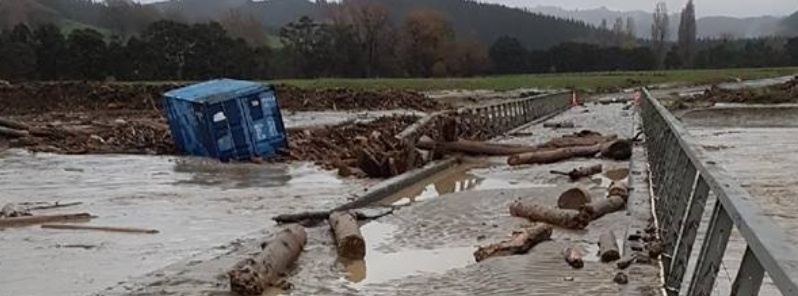
Featured image: Flooding in Gisborne after deep sub-tropical low hits North Island, New Zealand on June 12, 2018. Credit: Gisborne District Council
A deep sub-tropical low hit New Zealand's North Island on Tuesday, June 12, 2018 with heavy rain and strong winds, causing flooding, power outages and landslides. The heaviest rain fell on the east side of the North Island.
The storm dumped 130 mm (5.1 inches) of rain overnight to the Gisborne Ranges with another 110 mm (4.3 inches) or more expected by 16:00 local time today. Gusts at White Island peaked at 169 km/h (105 mph).
Schools were closed, communities cut off and thousands of homes and businesses left without power, from the East Coast to Hawke's Bay and Taranaki. Eastland Networks' general manager of networks said rain, wind and flying debris had caused outages and repair teams had been working all night.
Overnight rain has damaged roads and bridges while Waipaoa River flooded areas and cut off the small town of Te Karaka. The Hikuwai River has reportedly peaked at 11 m (36 feet) early Tuesday morning, and debris and logs were washing downstream. Mangahao River came close to breaching its banks.
Impressive swirl of rain around the low as it moves onshore. Watch the radar yourself on https://t.co/BmvSvfEaLb ^TA pic.twitter.com/laZCQkayti
— MetService (@MetService) June 12, 2018
Here's an update on the position of the low – due to move onto land around midday. ^TA pic.twitter.com/vanfBf1SsC
— MetService (@MetService) June 11, 2018
As the low pressure system passed near to our weather station on White Island it recorded a pressure of 988.3hPa. Not bad! ^TA pic.twitter.com/7En1YeUaT5
— MetService (@MetService) June 12, 2018
A look back at the last 24 hours of rainfall shows the heaviest rain on the east of the North Island. https://t.co/LoGzVbJO48 ^JL pic.twitter.com/Q3WiXTQWZ2
— MetService (@MetService) June 11, 2018
SH35 WAIPIRO – STOP/GO – 2:50PM
Due to a dropout, this road is under STOP/GO control between Te Araroa and Tolaga Bay, and CLOSED TO HEAVY VEHICLES. SH5 and SH2 are CLOSED. The only detour for heavy vehicles between Napier to Taupo is currently SH3. Please delay your travel. ^HJ pic.twitter.com/8be1zeft3g
— NZTA Central Nth Is (@NZTACNI) June 12, 2018
At 12:15 local time today, New Zealand's Met Service said the storm is expected to move south to lie near the central high country by midnight Tuesday, then move southeast and lie just southeast of central New Zealand by midnight Wednesday.
This deep sub-tropical low will bring heavy rain and gales to many parts of northern and central New Zealand, meteorologists said, advising residents to keep up to date with forecasts.
I'm a dedicated researcher, journalist, and editor at The Watchers. With over 20 years of experience in the media industry, I specialize in hard science news, focusing on extreme weather, seismic and volcanic activity, space weather, and astronomy, including near-Earth objects and planetary defense strategies. You can reach me at teo /at/ watchers.news.
Commenting rules and guidelines
We value the thoughts and opinions of our readers and welcome healthy discussions on our website. In order to maintain a respectful and positive community, we ask that all commenters follow these rules.