
More than 77k evacuated as deadly TS Urduja (Kai-Tak) drops massive rain on Philippines
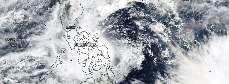
Featured image: Tropical Storm "Urduja" (Kai-Tak) on Decmber 16, 2017. Credit: NASA/NOAA Suomi NPP / VIIRS
A slow-moving Tropical Storm "Urduja," internationally known as "Kai-Tak," crawled toward the Philippines over the past couple of days, dropping massive amounts of rain. Urduja made landfall around 06:00 UTC on December 16 in the vicinity of San Policarpio, Eastern Samar and is expected to re-emerge over the warm waters of South China Sea early December 18 and reintensify. As of early December 16, at least 3 people have been killed and more than were 77 000 forced to evacuate.
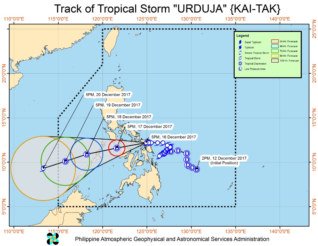
The system finally reached the northern part of Samar Province with maximum sustained winds of 75 km/h (47 mph) and gusts to 120 km/h (75 mph) today. The point of landfall was in the vicinity of San Policarpio, Eastern Samar around 06:00 UTC, December 16.
The storm has since weakened and is now traversing the Samar province, moving west at 15 km/h (9 mph). Meanwhile, a new tropical depression, currently located outside of the Philippine Area of Responsibility (PAR), is estimated based on all available data at 2 330 km (1 448 miles) east of Mindanao.
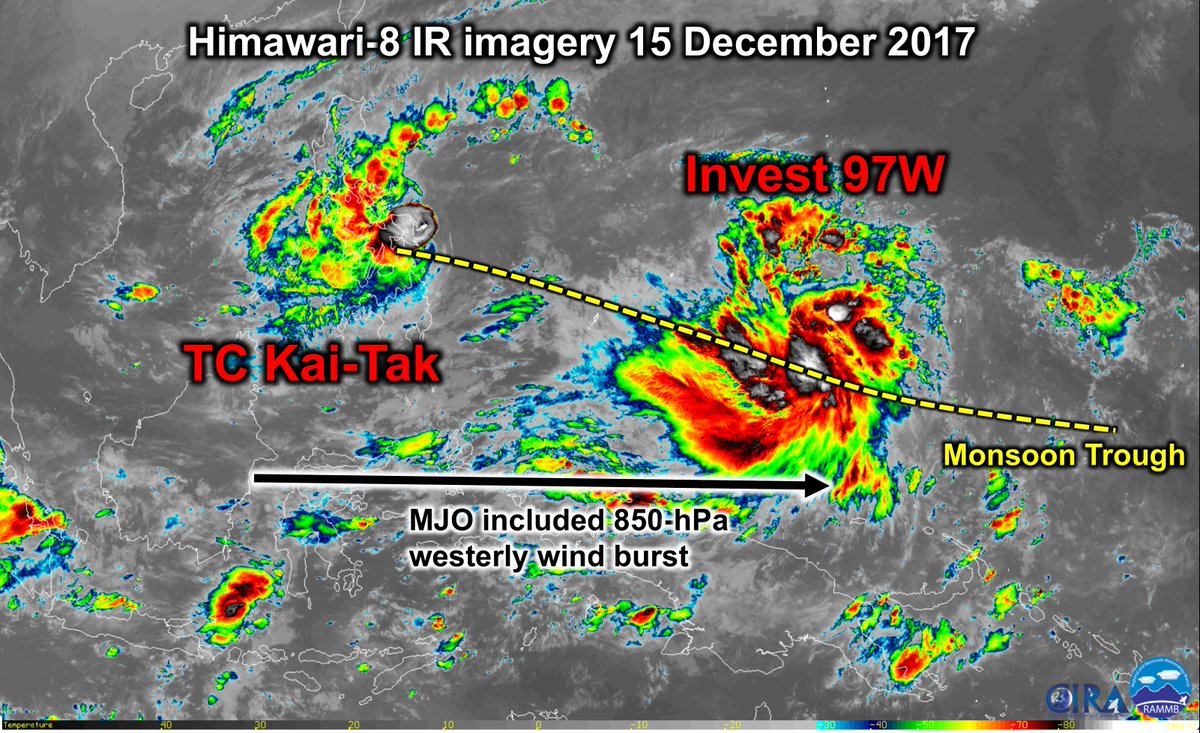
Image credit: CIRA/RAMMB, Philippe Papin
More than 970 mm (38 inches) of rain fell on Guiuan on the island of Samar in the Eastern Visayas since midweek, according to data provided by AccuWeather. In 24 hours alone, slow-moving Urduja dropped astonishing 780 mm (nearly 31 inches) of rain. To the north, Borongan City Airport has recorded 645 mm (25 inches) since Urduja began lashing the Philippines.
In addition to floods and landslides that blocked roads and buried homes, strong winds produced by the storm toppled trees and power pylons, knocking out power throughout the region.
According to AFP, local officials reported three deaths on Leyte island early Saturday morning, December 16 – a two-year-old boy who drowned in the town of Mahaplag, a woman buried by a landslide and another person who fell into a flooded manhole in Ormoc city.
More than 77 000 people from Samar and Leyte are in evacuation centers, local officials said.
Scattered to widespread rains will continue over Central and Western Visayas, Bicol Region, Southern Quezon, Batangas, Cavite, Laguna, Mindoro Provinces, Marinduque, Romblon and Cuyo Islands and is expected to prevail over Northern Palawan including Calamian group of Islands.
Residents of these areas must undertake appropriate measures against flooding and landslides and coordinate with their local disaster risk reduction and management offices, PAGASA said. Meanwhile, rains over Eastern Visayas are forecast to gradually weaken.
A Tropical Cyclone Warning Signal #1 is in effect for Southern Quezon, Marinduque, southern part of Occidental Mindoro, southern part of Oriental Mindoro Catanduanes, Camarines Sur, Albay, Burias Island, and Northern Palawan including Calamian Group of Islands in Luzon and the rest of Iloilo, rest of Antique, Guimaras, Negros Occidental, northern part of Negros Oriental, northern Cebu, Leyte, Eastern Samar, and rest of Samar in Visayas.
TCWS #2 is in effect for Sorsogon, Masbate including Ticao Island, Romblon, and Cuyo Islands in Luzon, and Northern Samar, northern part of Samar, Biliran, Aklan, Capiz, Northern Antique, and Northern Iloilo, Visayas.
Sea travel remains risky over the seaboards of areas under Tropical Cyclone Warning Signals.
Urduja (Kai-Tak) is expected to re-emerge over the warm waters of South China Sea sometime around 09:00 UTC on December 18. Around this time, a northeasterly wind surge is forecast to feed into the region imparting energy into the low level circualtion center.
Wind shear around this time is forecast to relax some but remain overall marginal. Environmental conditions will be favorable and this system will gradually reintensify.
I'm a dedicated researcher, journalist, and editor at The Watchers. With over 20 years of experience in the media industry, I specialize in hard science news, focusing on extreme weather, seismic and volcanic activity, space weather, and astronomy, including near-Earth objects and planetary defense strategies. You can reach me at teo /at/ watchers.news.
Thanks For Nice Detailed Information To The Watchers &Staff Too …
Yours,
Dr. Mangesh G. kavale