
Thomas Fire grows to 3rd largest in history of California, new evacuations ordered
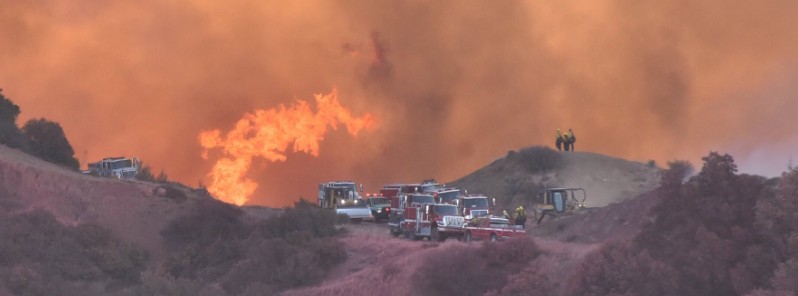
Featured image: Strike Teams dealing with erratic fire conditions on East Camino Cielo, above Montecito. Credit: VCFD PIO. Acquired: December 16, 2017
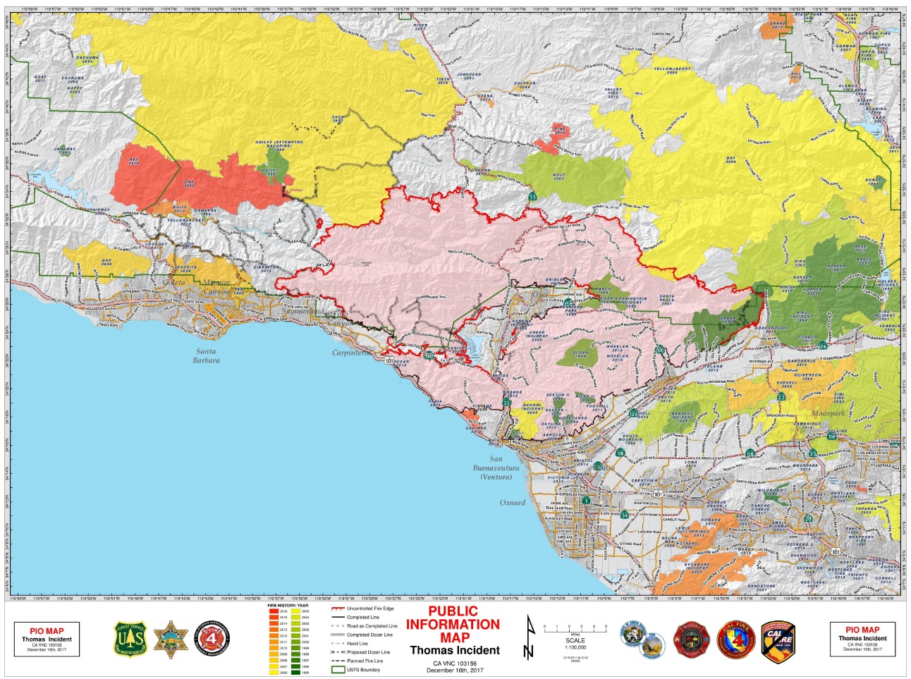
The Thomas Fire in California is burning for the 13th day in a row and has now grown to 259 000 acres (104 813 ha), making it the third largest wildfire in the history of California. As of December 16, the fire is only 40% contained and is still growing. One firefighter has lost its life.
Since the fire started on December 4, a total of 95 000 people have been placed under mandatory evacuation. New evacuations were ordered Saturday, December 16, as wind gusts up to 105 km/h (65 mph) brought it toward Montecito, the wealthiest community in Santa Barbara County, Summerland, and a portion of Santa Barbara City.
The Santa Barbara County Sheriff has issued:
An Evacuation Order for:
- Santa Barbara City: the area east of Hwy 154 to Mission Canyon Rd and north of Hwy 192 to East Camino Cielo.
- Montecito and Summerland Area – South of Hwy 192, North of Hwy 101, West of Toro Cyn, East of Summit Rd & Country Club
- SB City and Montecito north of Alameda Padre Serra/Hwy 101, south of Hwy 192, east of Mission Canyon Road, & west of Hot Springs & Summit Road.
An Evacuation Warning for:
- Santa Barbara City – from W. Mission Street, east to S. Salinas Street, from Hwy 101 to Alameda Padre Serra
- West of Santa Barbara City – North San Marcos Rd to HWY 154 and north of Cathedral Oaks Rd to the intersection of HWY 154 and North San Marcos Rd.
- The area from Constance/Alameda Padre Serra/South Salinas on the north and east, Highway 101 on the south, and West Mission St to State St on the west.
- All areas south of 101 to the coast & east of the zoo to San Ysidro Road. If you are in this area, prepare to leave
A complete list of evacuations and road closures may be found at: http://www.countyofsb.org/ and http://www.readyventuracounty.org/
Authorities remind the public to stay vigilant on current fire conditions. "Please continue to adhere to road closures and evacuation orders. Drive slowly and yield to emergency personnel in the area," the Santa Barbara Sheriff's Office said.
As of early December 16, the Thomas Fire has grown to 259 000 acres (104 813 ha), making it the 3rd largest wildfire in the history of California. The only fires larger than this one were the Cedar Fire in 2013 at 273 246 acres (110 578 ha) and the Rush Fire in 2012 at 271 911 acres (110 083 ha).
So far, the fire has destroyed 746 single family residences, 2 multiple residences, 2 mixed commercial/residential, 17 commercial structures and 242 other minor structures. 185 single family residences were damaged, 2 mixed commercial/residential and 42 other minor structures. 18 000 structures are still threatened.
A total of 8 370 firefighters are battling the blaze, 973 engines, 92 water tenders, 32 helicopters, 161 hand crews and 77 dozers. Firefighting costs have surpassed 100 million USD.
One firefighter (32) has died on Thursday, December 14 from burns and smoke inhalation.
For a larger image, click here.
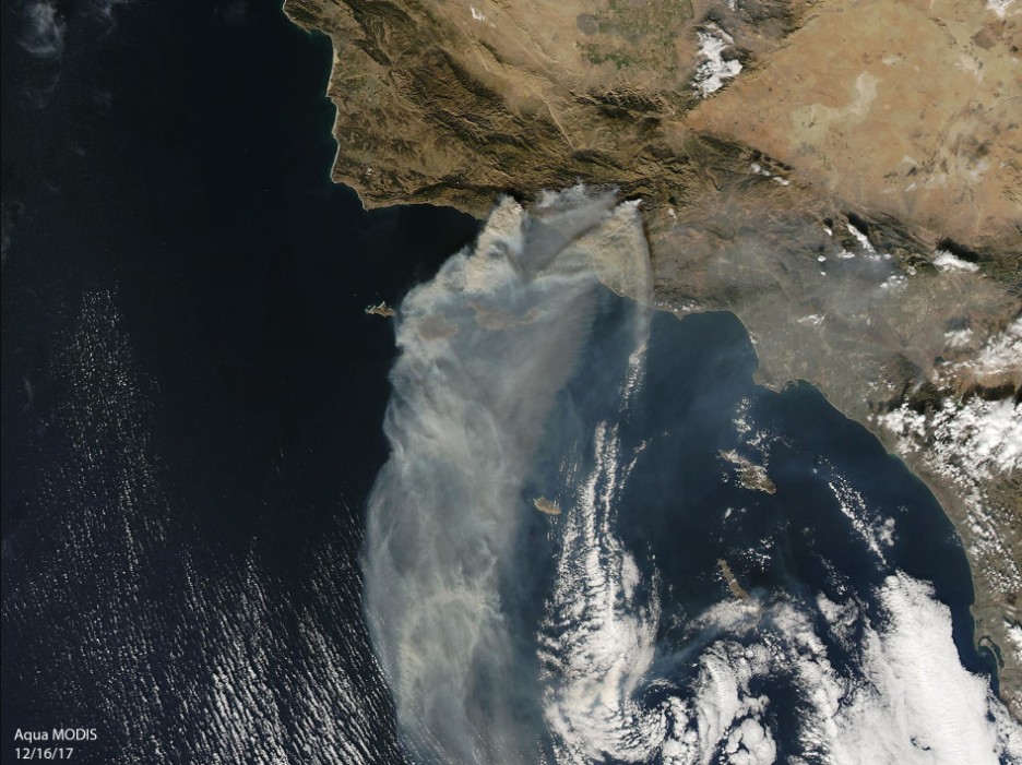
Thomas Fire from space on December 16, 2017. Credit: NASA Terra/MODIS.
Firefighters in Santa Barbara County will continue constructing direct fireline where possible with support from air resources, working to tie into the Tea Fire and Jesusita Fire footprints, authorities said Saturday.
Crews will remain engaged in structure defense operations. The threat to the communities of Santa Barbara, Carpinteria, Summerland and Montecito will continue.
In the eastern Ventura County, firefighters will improve the fireline that has been established to keep the fire out of the outlying areas of Fillmore. Indirect line extending north from Fillmore will continue, in preparation for future firing operations. To the north, fire spread within the areas of Bear Haven and the Day Fire will be closely monitored.
Fireline construction north of Camino Cielo connecting to the lighter fuels of the Zaca Fire footprint will continue. Fire growth to the west, north, and east will continue where lines have not been established.
On the north side of the fire, direct line construction and firing operations will continue in Rose Valley.
North to northeast winds, gusting between 40 – 65 km/h (25 – 40 mph), developed last night and this morning. With the northerly winds, relative humidity recovery was limited.
By this afternoon, the northerly winds will diminish but are expected to increase yet again late this afternoon and evening. Relative humidity will drop into the single digits and low teens once again.
A Red Flag Warning remains in effect for the Santa Barbara zone.
The estimated containment date is January 7, 2017.
I'm a dedicated researcher, journalist, and editor at The Watchers. With over 20 years of experience in the media industry, I specialize in hard science news, focusing on extreme weather, seismic and volcanic activity, space weather, and astronomy, including near-Earth objects and planetary defense strategies. You can reach me at teo /at/ watchers.news.
Commenting rules and guidelines
We value the thoughts and opinions of our readers and welcome healthy discussions on our website. In order to maintain a respectful and positive community, we ask that all commenters follow these rules.