
Heavy snow, subfreezing temperatures disrupt traffic across UK
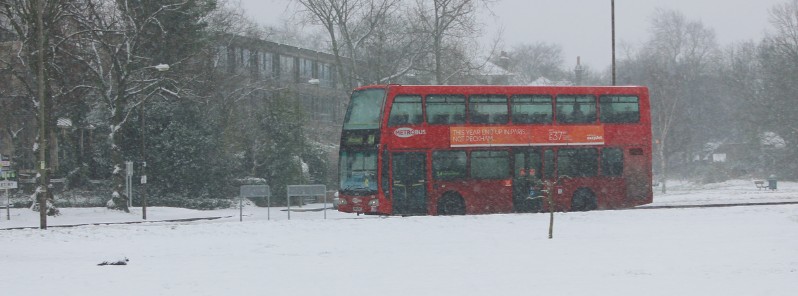
Image credit: Paul Wilkinson
Hundreds of schools are closed across the United Kingdom today, December 11, 2017, in the wake of Storm Caroline which moved away from British Isles December 8 toward Scandinavia. Caroline allowed cold arctic air to move in and cover the UK with bitterly cold temperatures and snow, causing severe traffic disruption and leaving tens of thousands without power. The deepest weekend snow fell over higher ground on northern and western areas. Temperatures dropped down to -12 °C (10.4 °F) overnight Monday and combined with precipitation for an icy start and dangerous morning rush hour.
Heavy snow has fallen across large parts of Wales and Central England with as much as 32 cm (12.6 inches) recorded in Sennybridge, Wales and 17 cm (6.7 inches) at High Wycombe, England. The heaviest snow has fallen through the morning on Sunday, with snow showers fading out through the evening and overnight.
"There have been some large falls of snow in parts of Wales and central England and these accumulations could still cause some disruption as we start the working week. After a cold night, there is likely to be ice in areas that have settled snow and also in parts of the southeast where rain pushes in from the southeast," the UK Met Office Chief Meteorologist Steve Ramsdale said Sunday.
Met Office issued Yellow warnings for snow and ice on Sunday. "Ice is expected to form in many places overnight into Monday morning. Some injuries are likely from slips and falls on icy surfaces as well as icy patches on some untreated roads, pavements and cycle paths. As well as this lying snow from Sunday will continue to be a hazard leading to longer and potentially hazardous journeys."
What meteorologists feared came true as temperatures dropped down to -12 °C (10.4 °F) overnight Monday and combined with precipitation for an icy start and dangerous morning rush hour.
RAC spokesman Pete Williams said he fears drivers will not going to leave enough time. "Driving conditions are going to be treacherous and journeys will take two to three hours longer," he said. "Overnight temperatures could cause black ice," Williams added, urging people to drive slowly, leaving plenty of space between them and the vehicle in front.
An update to the Yellow warning was issued Monday morning:
Ice has formed on some surfaces Monday morning as well as some snow falling, with small accumulations above around 100 m (328 feet). Some snow accumulations of 2 – 5 cm (0.8 – 2 inches) are possible above around 100 m but at lower levels, no accumulations are expected. Instead, a mixture of rain and sleet is most likely. Some injuries are possible from slips and falls on icy surfaces and there will probably be some icy patches on untreated roads and cycle paths. Some roads and railways are likely to be affected with longer and more difficult journeys.
The warning is in effect through 16:00 local time Monday.
Scottish and Southern Electricity Network said Monday morning some 3 000 customers spent a night without electricity, down from more than 50 000 on Sunday, after heavy snow and winds of up to 113 km/h (70 mph) caused damage to power lines. (Latest reports mention 99 500 homes without power overnight.)
Over 200 flights were canceled at Heathrow Airport, 7 at Edinburgh and 13 at Machester, as of early Monday morning.
Hundreds of schools are closed.
Forecast
Away from the southeast on Monday many places in the UK will have a bright, sunny but very cold start with snow showers confined to Scotland and Northern Ireland.
A ridge of high pressure will move across the UK on Tuesday bringing widespread fine and dry but still cold conditions. Overnight a front will move in from the west leading to all areas waking up to a much greyer rainy morning on Wednesday.
I'm a dedicated researcher, journalist, and editor at The Watchers. With over 20 years of experience in the media industry, I specialize in hard science news, focusing on extreme weather, seismic and volcanic activity, space weather, and astronomy, including near-Earth objects and planetary defense strategies. You can reach me at teo /at/ watchers.news.
Commenting rules and guidelines
We value the thoughts and opinions of our readers and welcome healthy discussions on our website. In order to maintain a respectful and positive community, we ask that all commenters follow these rules.