
Explosions at Fuego volcano ejecting ash up to 5 km (16 404 feet) a.s.l., Guatemala
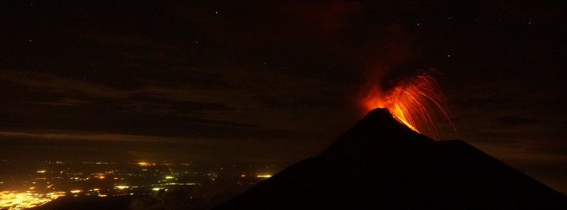
Image credit: Fuego volcano, Guatemala erupting on October 2, 2017. Image copyright Chris on Tour
Explosive activity at Guatemala's Fuego volcano is increasing over the past couple of hours, INSIVUMEH said in a special bulletin issued 16:00 UTC on October 5, 2017.
The explosions are loaded with abundant ash that reaches a height of approximately 5 km (16 404 feet) above sea level, 1.2 km (3 937 feet) above the crater, and traveling more than 20 km (12.4 miles) to the west, southwest, and south.
The incandescent material of various sizes is being ejected up to 300 m (984 feet) in the air and spread to more than 600 m (1 968 feet) from the crater. Moderate and strong avalanches are descending down the Cenizas and Seca ravines up to 1.5 km (0.93 miles).
Explosions are generating moderate to strong shock waves that rattle nearby structures.
There is a possibility that new lava flows will be generated over the next couple of hours and a new eruptive phase could start.
Civil protection agency recommends the population to take all necessary security measures and keep being informed through official channels. It is also important for tourists not to stay near the volcano as the ballistic material generated by these explosions could reach up to 5 km (3.1 miles).
Fuego’s ninth effusive eruption phase in 2017 began on September 13 and lasted some 35 hours. Explosions generated ash plumes that rose 1.2 km (3 937 feet) above the crater and drifted 15 km (9.3 miles) W and SW, causing ashfall in communities downwind including San Pedro Yepocapa (8 km / 5 mi N), El Porvenir (8 km ENE), and Sangre de Cristo (8 km WSW). Pyroclastic flows descended the Seca (Santa Teresa) ravine on the W flank.
INSIVUMEH noted that on September 14, explosions generated ash plumes that rose 750 m (2 460 feet) and drifted 10 km (6.2 miles) W and SW. A lava flow was active in the Santa Teresa ravine. Explosions on September 15 produced ash plumes that rose as high as 750 m (2 460 feet) and drifted 5 km (3.1 miles) NW and SW. The lava flow was 300 m (984 feet) long.
During September 17 – 18 ash plumes from explosions rose almost 1 km (3 280 feet) and drifted W and SW. Incandescent material was ejected 250 m (820 feet) above the crater rim, and caused avalanches of material around the crater area. Ashfall was reported in areas including Panimaché I and II (8 km SW), Morelia (9 km / 5.6 mi SW), and El Porvenir.
Its tenth eruptive phase of the year started on September 28, with two lava flows descending down the Seca and Las Lajas ravines up to 600 m (1 968 feet). Explosions generated a column of ash that reached about 4.8 km (16 043 feet) above sea level and traveled more than 30 km (18.6 miles) to the west and northwest. Ashfall was reported in areas including La Soledad, Pastores, San Miguel Duenas and Antigua.
Fuego's strongest eruption since 2012 occurred on May 5, 2017, producing pyroclastic flows and ejecting thick volcanic ash cloud to an estimated altitude of 5 km (16 405 feet) above sea level. INSIVUMEH described it as one of the strongest eruptions in recent years, recommending CONRED to raise the alert level to Orange.
In a special bulletin released 17:00 UTC on May 5, INSIVUMEH said volcanic ash cloud is moving more than 50 km (31 miles) to the south, southwest and west and generating ashfall in San Pedro Yepocapa, Morelia, Santa Sofía, El Porvenir, Palo Verde and others on this side, like Santa Lucia Cotzumalguapa, Siquinala, San Andres Osuna, Chuchu and La Reunión.
Geological summary
Volcán Fuego, one of Central America's most active volcanoes, is one of three large stratovolcanoes overlooking Guatemala's former capital, Antigua. The scarp of an older edifice, Meseta, lies between 3 763 m (12 345.8 feet) high Fuego and its twin volcano to the north, Acatenango. Construction of Meseta dates back to about 230 000 years and continued until the late Pleistocene or early Holocene. The collapse of Meseta may have produced the massive Escuintla debris-avalanche deposit, which extends about 50 km (31 miles) onto the Pacific coastal plain.
Growth of the modern Fuego volcano followed, continuing the southward migration of volcanism that began at Acatenango. In contrast to the mostly andesitic Acatenango, eruptions at Fuego have become more mafic with time, and most historical activity has produced basaltic rocks. Frequent vigorous historical eruptions have been recorded since the onset of the Spanish era in 1524, and have produced major ashfalls, along with occasional pyroclastic flows and lava flows. (GVP)
I'm a dedicated researcher, journalist, and editor at The Watchers. With over 20 years of experience in the media industry, I specialize in hard science news, focusing on extreme weather, seismic and volcanic activity, space weather, and astronomy, including near-Earth objects and planetary defense strategies. You can reach me at teo /at/ watchers.news.
Commenting rules and guidelines
We value the thoughts and opinions of our readers and welcome healthy discussions on our website. In order to maintain a respectful and positive community, we ask that all commenters follow these rules.