
Tropical Storm “Nate” forms near Nicaragua, heading toward US Gulf Coast
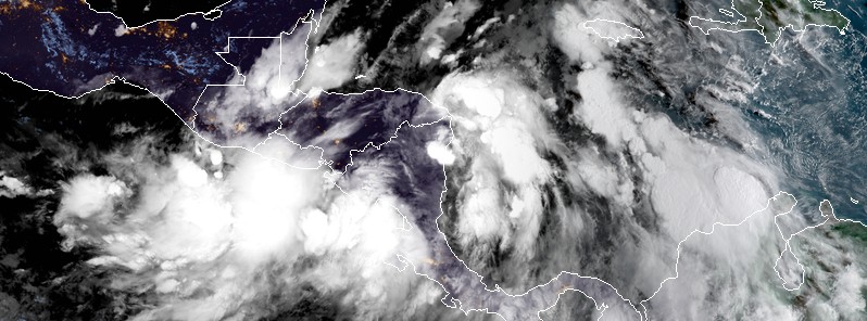
Featured image: Tropical Storm "Nate" at 11:45 UTC on October 5, 2017. Credit: NOAA-GOES16 (preliminary and non-operational)
Tropical Depression 16L strengthened into a tropical storm near the eastern coast of Nicaragua at 12:00 UTC on October 5, 2017 and was named Nate. The system is expected to move across northeastern Nicaragua and eastern Honduras today, producing flooding rain and strengthen into a hurricane before it makes landfall on the US Gulf Coast on Sunday, October 8.
At 12:00 UTC (08:00 EDT) on October 5, the center of Tropical Storm "Nate" was located just about 15 km (10 miles) south of Puerto Cabezas, Nicaragua. The system has maximum sustained winds of 65 km/h (45 mph) and minimum central pressure of 999 hPa. The system is heading NW at 13 km/h (8 mph). Little change in strength is expected today.
Nate is the 14th named storm of the unusually active 2017 Atlantic Hurricane season. This is now the 10th year on record with 14+ named storms through October 5.
On the forecast track, Nate should move across northeastern Nicaragua and eastern Honduras today and then over the northwestern Caribbean Sea tonight and Friday. It is expected to approach the coast of Yucatan peninsula late Friday and be near Louisiana, Mississippi and Alabama on Sunday, October 8, most likely as a Category 1 hurricane.
Tropical-storm-force winds extend outward up to 95 km (60 miles) mainly over water to the east of the center.
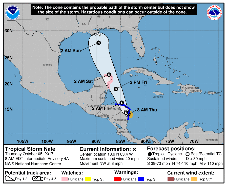
A Tropical Storm Warning is in effect for:
- Sandy Bay Sirpi Nicaragua to Punta Castilla Honduras
A Tropical Storm Warning means that tropical storm conditions are expected somewhere within the warning area.
A Hurricane Watch is in effect for:
- Punta Herrero to Rio Lagartos Mexico
A Hurricane Watch means that hurricane conditions are possible within the watch area. A watch is typically issued 48 hours before the anticipated first occurrence of tropical-storm-force winds, conditions that make outside preparations difficult or dangerous.
Interests elsewhere in Honduras, the Bay Islands, western Cuba and the Yucatan Peninsula should monitor the progress of Nate.
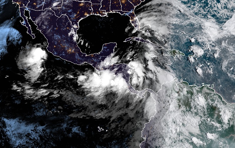
Tropical Storm "Nate" at 11:45 UTC on October 5, 2017. Credit: NOAA-GOES16
Nate is expected to produce the following rain accumulations through Friday night:
- Nicaragua: 381 – 508 mm (15 to 20 inches), isolated 762 mm (30 inches)
- Costa Rica and Panama: 127 – 254 mm (5 to 10 inches), isolated 508 mm (20 inches)
- Honduras and Belize: 50.8 – 127 mm (2 to 5 inches), isolated 203 mm (8 inches)
- Eastern portions of the Yucatan peninsula: 101.6 – 203.2 mm (4 to 8 inches), isolated 304.8 mm (12 inches)
Heavy rainfall will occur over a wide area, including locations well away from the center along the Pacific coast of Central America. This rainfall could cause life-threatening flash floods and mudslides.
Tropical storm conditions are expected within portions of the warning area in Nicaragua and Honduras today and tonight. Tropical storm and hurricane conditions are possible within the watch area in Mexico beginning late Friday.
Swells generated by Nate are affecting portions of the coast of Nicaragua, and will begin to affect other land areas around the northwestern Caribbean later this week. These swells are likely to cause life-threatening surf and rip current conditions.
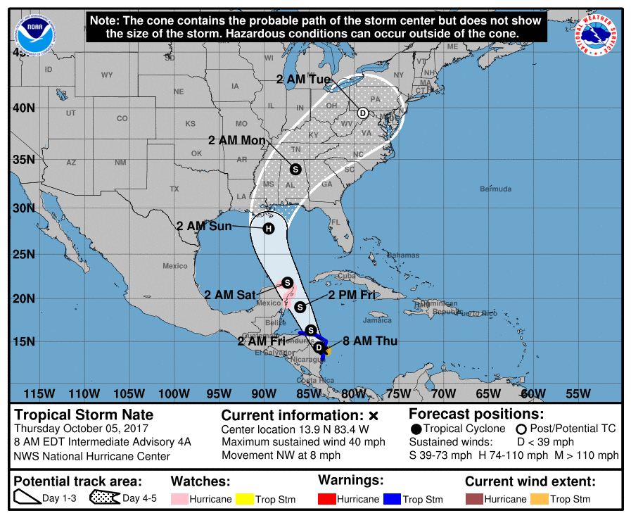
"Nate will make landfall along the US upper Gulf coast on Sunday," according to AccuWeather Meteorologist Brett Rossio.
Since Nate will be moving inland over the U.S. this weekend, people may have little time to react and prepare for a tropical storm or hurricane.
The U.S. Gulf coast areas from Florida to Alabama, Mississippi and southeastern Louisiana may be at risk for damaging winds, coastal flooding, rough surf and beach erosion this weekend and into early next week.
"In all likelihood, this storm will impact areas not severely impacted by Harvey or Irma. The extent of the damage will depend, of course, on the precise path and whether the storm intensifies beyond a Category 1 storm," AccuWeather Founder, President and Chairman Dr. Joel N. Myers said. "The most likely place for it to hit is the Florida Panhandle."
I'm a dedicated researcher, journalist, and editor at The Watchers. With over 20 years of experience in the media industry, I specialize in hard science news, focusing on extreme weather, seismic and volcanic activity, space weather, and astronomy, including near-Earth objects and planetary defense strategies. You can reach me at teo /at/ watchers.news.
Commenting rules and guidelines
We value the thoughts and opinions of our readers and welcome healthy discussions on our website. In order to maintain a respectful and positive community, we ask that all commenters follow these rules.